
Pontypridd facts for kids
Quick facts for kids Pontypridd |
|
|---|---|
 Pontypridd |
|

Pontypridd
|
|
| Population | 32,694 (2011) |
| OS grid reference | ST075895 |
| Community |
|
| Principal area |
|
| Ceremonial county | |
| Country | Wales |
| Sovereign state | United Kingdom |
| Post town | PONTYPRIDD |
| Postcode district | CF37 |
| Dialling code | 01443 |
| Police | South Wales |
| Fire | South Wales |
| Ambulance | Welsh |
| EU Parliament | Wales |
| UK Parliament |
|
| Welsh Assembly |
|
Pontypridd is a town in Wales, often called "Ponty" by locals. It is the main town of Rhondda Cynon Taf and a local community area. Pontypridd is about 12 miles north of Cardiff, the capital city of Wales.
Contents
Exploring Pontypridd's Location
Pontypridd is made up of several areas, like Cilfynydd, Hawthorn, and Treforest. The town is located where the River Rhondda flows into the River Taff. This meeting point is just south of the town, near Ynysangharad War Memorial Park.
In 2011, about 32,700 people lived in the Pontypridd community. The town is also on the main A470 highway. This road connects Cardiff to Merthyr Tydfil. Other roads like the A4054 and A4058 also pass through or near the town.
A Look at Pontypridd's Past
What Does Pontypridd Mean?
The name Pontypridd comes from the Welsh words Pont-y-tŷ-pridd. This means "bridge by the earthen house." This name refers to old wooden bridges that used to cross the River Taff here.
The Famous Old Bridge
Pontypridd is well-known for its Old Bridge. This stone bridge was built in 1756 by William Edwards. It was his third try to build a bridge here. When it was finished, it was the longest single-span stone arch bridge in the world.


The bridge rises 35 feet above the river. It forms a perfect curve, 140 feet wide. It has three holes of different sizes at each end. These holes help to make the bridge lighter. However, the bridge was very steep, making it hard for horses and carts to cross. Because of this, a new bridge called the Victoria Bridge was built next to it in 1857. For a while, Pontypridd was even known as Newbridge.
Pontypridd and Coal Mining
The history of Pontypridd is closely linked to the coal and iron industries. Before these industries grew, Pontypridd was mostly farmland. Treforest was the main town nearby at first.


Pontypridd became important for moving coal and iron. Coal came from the Rhondda Valley. Iron came from Merthyr Tydfil. These goods were transported by the Glamorganshire Canal and later by the Taff Vale Railway. They went to ports like Cardiff and Barry. Because of its role in coal transport, Pontypridd's railway platform was once thought to be the longest in the world.
In the late 1800s, Pontypridd was a very busy industrial town. It was even nicknamed the 'Wild West'. Several coal mines, called collieries, were in the Pontypridd area. One of the worst mining accidents in South Wales happened at the Albion Colliery in Cilfynydd in 1894. This event led to the deaths of 290 miners.
Iron and Steel Production
Other important industries in Pontypridd included the Brown Lenox/Newbridge Chain & Anchor Works. There were also Crawshay's Forest Iron, Steel & Tin Plate Works and the Taff Vale Iron Works in Treforest. These factories were near what is now the University of South Wales.
Images for kids
-
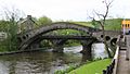
Old Bridge, dating from 1756
-
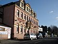
The Cilfynydd Commercial Hotel in Cilfynydd
-
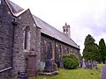
St. David's Church in Hopkinstown
-
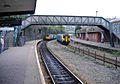
Railway station
-

Glamorgan Business School (university)
-

Sardis Road rugby ground
-

The former paddling pool in Ynysangharad Park, now removed
-

The pitch and putt golf course in Ynysangharad Park, now removed
-

The bandstand in Ynysangharad Park
-
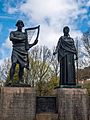
A memorial in Ynysangharad Park to Evan James and James James, composers of the Welsh national anthem
.jpg)


See also
 In Spanish: Pontypridd para niños
