Waun Lefrith facts for kids
Quick facts for kids Waun Lefrith |
|
|---|---|

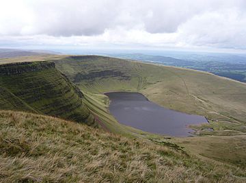
Waun Lefrith from Picws Du
|
|
| Highest point | |
| Elevation | 677 m (2,221 ft) |
| Prominence | 15 m (49 ft) |
| Parent peak | Picws Du |
| Listing | Nuttall |
| Naming | |
| English translation | milk bog |
| Language of name | Welsh |
| Geography | |
| Location | Carmarthenshire, Wales |
| Parent range | Brecon Beacons |
| OS grid | SN825217 |
Waun Lefrith is a mountain peak in Wales. It's part of the Carmarthen Fans or Bannau Sir Gaer. These peaks are found within the Black Mountain area. This whole region is part of the beautiful Brecon Beacons National Park.
Waun Lefrith is the most western peak of the Carmarthen Fans. It stands tall in Carmarthenshire, Wales. The very top of the mountain is 2,221 feet (677 meters) above sea level. Other higher peaks in the area include Picws Du and Fan Foel.
To the north of Waun Lefrith, you can see a stunning glacial lake called Llyn y Fan Fach. Further north, you might spot the Usk Reservoir and even the Cambrian Mountains far away. If you look south, you can see Swansea Bay and the Bristol Channel.
Contents
What is Waun Lefrith Made Of?
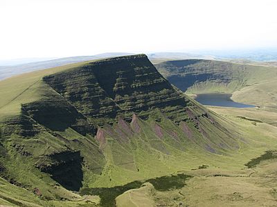
Waun Lefrith is made from special types of rock. These rocks are called sandstones and mudstones. They belong to something called the Brownstones Formation. These rocks formed a very long time ago, during the Devonian period.
The southern parts of the mountain have even tougher sandstones. These are from the Plateau Beds Formation. These strong rocks create tall, steep cliffs along the mountain's edge.
How Glaciers Shaped the Mountain
During the ice ages, a huge glacier sat on the northern side of Waun Lefrith. This glacier slowly carved out a bowl-shaped valley. This valley is called a cwm. Today, Llyn y Fan Fach lake sits in this cwm.
Water from the lake flows into the Afon Sawdde. This river then joins the River Towy. On the southern slopes, water flows into smaller streams. These streams eventually reach the Afon Twrch and then the River Tawe. You can also see large piles of rock and dirt left by the glaciers. These are called moraines.
Exploring Waun Lefrith
You can freely explore all of Waun Lefrith. It's a great place for walkers and hikers. The most popular way to climb the mountain starts from a car park. This car park is near a road that goes up to Llyn y Fan Fach. The mountain looks huge above the lake.
The car park is east of a small village called Llanddeusant. Be careful if you drive, as the road can be rough.
Popular Walking Routes
A path starts at the dam of Llyn y Fan Fach. There's a small hut there called a bothy where you can take shelter. The path goes up the hill to the west. Then it turns and follows the edge of the cliff above the lake. Walking along this cliff edge gives you amazing views of the lake below. But always be careful, especially if the weather is bad.
The Beacons Way is a long walking trail. Its high-level route goes right over Waun Lefrith. The low-level route goes along the bottom of the northern cliffs. This route passes by Llyn y Fan Fach.
Most of the top of the mountain has peat bogs. These are wet, spongy areas. But the main footpaths often have stone pavements. These help protect the path and make walking easier. The path follows the edge of the cliffs, giving you wide views in every direction.
Staying Safe on the Mountain
It's very important to be careful when hiking in the mountains. The weather can change quickly. Visibility can drop because of mist, fog, or heavy rain and snow. When this happens, it's hard to see where you're going. Walking near the cliff edge can become dangerous.
Always carry a prismatic compass and a local map. These tools will help you find your way. Not many people hike on the Black Mountain. So, you should be ready to rely on yourself if you need help.
Animals and Birds of Waun Lefrith

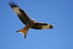
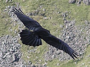
Waun Lefrith is home to many different kinds of birds. You might see the beautiful red kite flying high. Other birds include the common buzzard, kestrel, and carrion crow. You might also spot a common raven or a jackdaw. The cheerful skylark is also a common resident.
The kestrel and common buzzard are found all over the area. But the common raven prefers the higher parts of the mountains. The red kite almost disappeared from other parts of Britain. But it survived here because there wasn't much hunting of game birds. Thanks to groups like the RSPB, red kites have now been brought back to many areas.
Other Wildlife

You can also find game birds like pheasants and red grouse. Many mammals live here too. These include small field voles, clever foxes, and shy badgers. There are also many different songbirds.
The skylark is very common here. This is because there are large areas of rough grassland below the main peaks. This is a perfect place for skylarks to build their nests on the ground. You might see pied wagtails near the streams and fast-flowing water coming down from the hills.
 | John T. Biggers |
 | Thomas Blackshear |
 | Mark Bradford |
 | Beverly Buchanan |


