
Peak District facts for kids
Quick facts for kids Peak District National Park |
|
|---|---|
| "The Peak" | |
|
IUCN Category V (Protected Landscape/Seascape)
|
|

A view of Mam Tor, Peak District National Park
|
|

Peak District National Park (shaded green) within England
|
|
| Location | Derbyshire Cheshire Greater Manchester Staffordshire South Yorkshire West Yorkshire |
| Area | 555 sq mi (1,440 km2) |
| Designated | 17 April 1951 |
| Visitors | Over 10 million |
| Administrator | National park authority |
The Peak District is a beautiful hilly area in England. It is located at the southern end of the Pennines mountain range. Most of it is in northern Derbyshire. However, parts also stretch into Cheshire, Greater Manchester, Staffordshire, and Yorkshire.
This special area has two main parts. The northern part is called the 'Dark Peak'. It has lots of moorland, which are open, wild areas. The rocks here are mainly gritstone. The southern part is known as the 'White Peak'. More people live here, and its rocks are mostly limestone.
Much of the Peak District is high up, over 300 meters (1,000 feet) above sea level. The highest point is Kinder Scout, which is about 636 meters (2,087 feet) tall. Even though it's called the "Peak" District, the landscape doesn't have many sharp, pointy peaks. Instead, you'll find rounded hills and steep rock faces called "edges." Big cities like Manchester and Sheffield are close by.
Traveling through the Peak District can be tricky. The roads are often narrow and few. This is because the land is very hilly, rough, and uneven. Large motorways run on the east and west sides of the area.
The Peak District National Park was the very first national park in the United Kingdom. It was created on April 17, 1951. Many visitors come to explore its beauty every year.
Contents
Understanding Peak District Rocks
The Peak District is mostly made of sedimentary rocks. These rocks formed during the Carboniferous period, a very long time ago. They include limestone, gritstone, and coal measures. You can also find some igneous rocks here. These include lava and rocks from ancient volcanic vents. The whole Peak District looks a bit like a wide dome shape.
How the Landscape Formed
After the Carboniferous period, the Earth's crust moved. This pushed the area upwards, creating the dome shape we see today. Over time, softer rocks like shale and sandstone wore away. This exposed the harder limestone underneath. Later, the area was covered by sea, which added new layers of rock.
Minerals like lead formed in the limestone rocks. People have been mining for lead here since Roman times.
Ice Ages and Caves
The Peak District was covered by ice during at least one ice age. This happened in the last 2 million years. When the ice melted, it carved out many winding channels. These meltwaters also helped to form the many cave systems in the limestone areas. Remains of wild animals have been found in some of these local caves.
Rocks and the Landscape
The different types of rock under the ground really shape the landscape. They decide what kinds of vegetation will grow. This, in turn, affects what animals can live there.
- Limestone: This rock has cracks (fissures) and dissolves in water. So, rivers often create deep, narrow valleys here. The water then goes underground, forming amazing cave systems.
- Millstone Grit: This rock doesn't dissolve but is porous, meaning it soaks up water. Water moves through the grit until it hits less porous rocks below. This creates springs when the water comes back to the surface.
- Shale: This rock is crumbly and easily broken down by frost. It can lead to landslides, like those seen on Mam Tor.
Images for kids
-
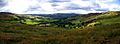
A High Peak panorama between Hayfield and Chinley
-
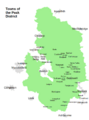
Towns around the Peak District
-
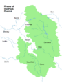
Rivers around the Peak District
-
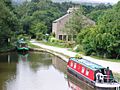
The Bugsworth Basin on the Peak Forest Canal
-
Thor's Cave seen from the Manifold Way
-
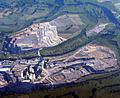
Tunsted Quarry
-
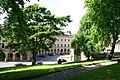
Buxton Crescent and St Ann's Well
-
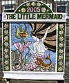
A well dressing at Hayfield
-
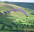
Paragliding from Mam Tor
-
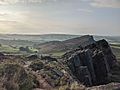
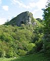
Looking southeast over the Roaches and Hen Cloud
-
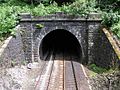
Totley Tunnel on the Manchester to Sheffield Hope Valley line
-
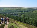
Walkers above the Derwent Reservoir
-
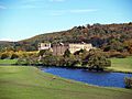
Chatsworth House, the setting for a 2005 adaptation of Pride and Prejudice
-
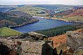
Ladybower Reservoir in the Upper Derwent Valley, set location for The Dam Busters


See also
 In Spanish: Peak District para niños
