
Edale facts for kids
Quick facts for kids Edale |
|
|---|---|
 Holy Trinity parish church |
|

Edale
|
|
| Population | 353 (2011 Census) |
| OS grid reference | SK122856 |
| District |
|
| Shire county | |
| Region | |
| Country | England |
| Sovereign state | United Kingdom |
| Post town | HOPE VALLEY |
| Postcode district | S33 |
| Dialling code | 01433 |
| Police | Derbyshire |
| Fire | Derbyshire |
| Ambulance | East Midlands |
| EU Parliament | East Midlands |
| UK Parliament |
|
Edale is a small village and parish in the beautiful Peak District area of Derbyshire, England. In 2011, about 353 people lived here. Edale is located in the Borough of High Peak and covers an area of about 7,030 acres.
This village is super popular with walkers! It's famous for being the start (or southern end) of the long-distance walking path called the Pennine Way. Even if you're not tackling the whole Pennine Way, Edale is a great place to begin shorter walks for an afternoon or a day. You can easily get to Edale by train from Sheffield and Manchester, with trains usually running every hour. There are also two friendly pubs where you can grab a bite to eat and some drinks.
Contents
A Look Back in Time
The name "Edale" was first written down as we know it today in 1732. But older versions of the name, like Aidele, go all the way back to 1086!
Historically, Edale was the name for the whole valley where the River Noe flows. After the Norman Conquest of England, this area was part of the royal Forest of High Peak. At the heart of it all is the Edale Cross. This cross marked the border of three important areas within the forest. The valley is home to several small settlements called booths. These started in the 1200s as 'vaccaries', which were farms for raising cattle. Over time, these farms grew into the hamlets we see today, like Upper Booth, Barber Booth, Grindsbrook Booth, Ollerbrook Booth, and Nether Booth.
Edale's Old Cotton Mill
Edale is also home to a historic cotton mill that was built in 1795. It was put together by Nicholas Cresswell and his partners on the site of an even older corn mill and tannery. Workers came from nearby towns to work at the mill. They lived in small cottages and a house called Skinner's Hall. Many women workers would walk every day from Castleton, crossing the high Hollins Cross pass which is over a thousand feet tall! The mill kept spinning cotton until about 1940. After that, it wasn't used for a while. In the early 1970s, the Landmark Trust restored it, and now it has apartments.
Exploring the Outdoors

Besides being the start of the Pennine Way (which officially begins at the Old Nag's Head pub, a building from 1577!), Edale is surrounded by amazing walking country. The village sits in the beautiful Vale of Edale. It's surrounded by impressive hills:
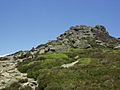
- To the north, you'll find the high plateau of Kinder Scout, which is the highest point in the parish.
- To the south and east, there's the Great Ridge, which stretches from Rushup Edge over Mam Tor to Lose Hill.
- To the east, you can see Win Hill (though it's just outside the parish).
- To the west, there's Dalehead, with peaks like Brown Knoll.
Almost all of Edale parish is more than 200 meters (about 656 feet) above sea level! Only along the River Noe, east of Carr House, does the land drop below this height.
The River Noe, from Barber Booth upstream, is a special area called the Edale SSSI. This means it's important for its geology. The rocks here, called Edale Shales, have interesting fossils that scientists study.
Places to Stay and Visit

If you want to stay in Edale, you have a few choices! There's a youth hostel about a mile from the village center. You can also find several B&Bs, and both pubs offer rooms too. Besides the pubs, there are two cafés where you can get food and drinks.
In 2006, a new information and visitor center opened at Fieldhead. This center was created by the Moors for the Future partnership and is run by the Peak District National Park Authority. It's a great place to learn more about the area. Edale is also a popular spot for camping, with two main campsites and many others nearby.
News and Entertainment
For TV news, people in Edale watch BBC Yorkshire and ITV Yorkshire, which are based in Leeds. Local radio stations include BBC Radio Derby and Greatest Hits Radio Derbyshire (High Peak). You can also read local news in the Peak Advertiser and the Buxton Advertiser newspapers.
Getting Around

Edale railway station is on the Hope Valley line, which connects places across the Pennines. Even though it's a rural area, trains come quite often. Usually, there's one train an hour in both directions, heading to Sheffield and to Manchester Piccadilly (via Marple). These train services are run by Northern Trains.
The road leading to the village center is short, narrow, and winding, and it's a dead end. This means it's not really suitable for visitors' cars, and finding parking in the village center is very hard. However, there's a large pay-and-display car park near the village hall. You can also find parking for train users at the railway station. When it's busy, the Parish Council provides even more parking near the station.
Famous People from Edale
- Nicholas Cresswell (1750–1804) – A local farmer who kept a diary about his time in America.
- Peter Cropper (1945–2015) – A talented violinist.
- Berlie Doherty – A well-known novelist, poet, playwright, and screenwriter.
- Anthony Favell – A Conservative Member of Parliament (MP).
- Bella Hardy – A folk musician.
- Frederick ('Fred') Heardman – Received the British Empire Medal for his contributions.
- Mark Wallington – A writer.
Images for kids
-
Ringing Roger

Panorama

