
Vale of Edale facts for kids
Quick facts for kids Vale of Edale |
|
|---|---|

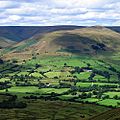
Looking east from Horsehill Tor
|
|
| Length | c.7 kilometres (4 mi) |
| Width | c.2 kilometres (1 mi) |
| Depth | c.300 metres (984 ft) |
| Geography | |
| Location | Derbyshire, England |
| Rivers | River Noe |
The Vale of Edale is a beautiful valley in the Peak District of England. It is in the county of Derbyshire. The valley is the upper part of the River Noe. The village of Edale sits right in the middle of this valley.
The River Noe starts high up on the Kinder Scout plateau. This river then flows through the Vale of Edale. It eventually joins the River Derwent. The river leaves the valley and flows into the Hope Valley. It passes through the village of Hope. It also goes past Brough-on-Noe, where ancient Romans once built a fort called Navio.
Contents
Exploring the Edale Valley Landscape
The Vale of Edale is surrounded by amazing natural features.
What are the Valley's Borders?
To the north, you'll find the wide, open moorland of Kinder Scout. This is a high, flat area. To the south, there is a long ridge. This ridge includes Rushup Edge and the Great Ridge. Famous spots like Mam Tor, Hollins Cross, and Lose Hill are part of this ridge.
What Villages are in the Valley?
Besides Edale village, there are smaller places called hamlets. These include Upper Booth, Barber Booth, and Nether Booth. They are all part of the peaceful valley.
Travel and History in Edale
The valley has been an important route for a long time.
How Does the Railway Cross the Valley?
The Hope Valley railway line runs right through the Vale of Edale. This train line connects the cities of Manchester and Sheffield. The railway was built by the Midland Railway company. Edale railway station opened in 1894. At the western end of the valley, the train line goes through the Cowburn Tunnel. This tunnel is about 3.4 kilometers (2.1 miles) long. It goes under the moorland hill called Brown Knoll.
What is the Pennine Way?
Edale is the starting point for the Pennine Way. This is a very long walking path. It stretches all the way from Derbyshire to Scotland. The path goes west through Upper Booth. Then it climbs up a famous footpath called Jacob's Ladder to the Kinder plateau.
The Historic Packhorse Bridge
At the bottom of Jacob's Ladder, there is an old stone bridge. It's called a packhorse bridge. It has one arch and crosses the River Noe. This bridge is very old and important. It was used in the Middle Ages for carrying goods. People used packhorses to move things like salt and cheese from Cheshire. Cotton from Lancashire mills was also carried east. In return, coal and lead were taken west. An ancient Roman road called Doctor's Gate also ran along the hillside at the eastern end of the valley.
Nature and Wildlife in Edale
The Vale of Edale is a special place for nature.
What is a Site of Special Scientific Interest?
The land along the River Noe, between Barber Booth and Jacob's Ladder, is protected. It is called an Edale SSSI. SSSI stands for Site of Special Scientific Interest. This means it's a place with important natural features. The riverbanks and riverbed here have important fossils. These fossils are found in rocks called Edale Shales.
What Animals and Plants Live Here?
You might see different birds in the valley. These include kestrels, buzzards, and curlews. The hillsides are covered with trees like birch, rowan, and alder. The National Trust owns and looks after the land where Jacob's Ladder footpath is. This area is also part of the Kinder Scout SSSI. In 2009, it was made a National Nature Reserve. This gives it even more protection.
Images for kids
-
View from Mam Tor over the Vale of Edale to Kinder
-
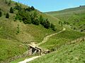
Packhorse bridge at the foot of Jacob's Ladder


