Hollins Cross facts for kids

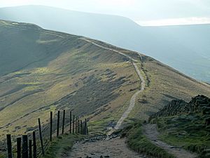
Hollins Cross is a special place located in the beautiful Peak District in Derbyshire, England. It sits right between two famous hills, Mam Tor and Lose Hill, on a long, high ridge called the Great Ridge. This ridge separates two valleys: Castleton on one side and Edale on the other.
Contents
What is Hollins Cross?
Hollins Cross is the lowest point along the Great Ridge. Because it's the easiest place to cross, it has been an important pathway for a very long time. Today, it's a super popular spot for walkers and hikers who want to explore the stunning countryside.
A Path Through History
For many years, Hollins Cross was the main way to travel between the villages of Castleton and Edale. It even earned a nickname: the "coffin road." This is because, a long time ago, before Edale had its own church, people from Edale had to carry their coffins over Hollins Cross to the church in Hope for burials. Imagine walking that path!
Exploring the Paths Around Hollins Cross
There are several well-used paths that lead to Hollins Cross from both sides of the ridge. These paths offer different kinds of walks.
The Path to Mam Tor
If you head west from Hollins Cross, you'll find a gentle climb on a paved path. This path is about one kilometer long and leads you straight to the top of Mam Tor. It's a great walk with amazing views.
The Path to Lose Hill
Going east from Hollins Cross, the path is a bit more challenging at first. The climb up to Back Tor is unpaved and can be a bit rough. But once you get past Back Tor, the path becomes paved again and continues on to Lose Hill.
The Memorial at Hollins Cross
Hollins Cross is named after an actual cross that used to stand there many years ago, but it disappeared by 1905. Today, you'll find a memorial at this spot. It was put there in 1964 by a group called the Long Eaton and District Group of the Ramblers Association. This memorial honors a person named Tom Hyett.
 | May Edward Chinn |
 | Rebecca Cole |
 | Alexa Canady |
 | Dorothy Lavinia Brown |

