
Lose Hill facts for kids
Quick facts for kids Lose Hill |
|
|---|---|

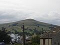
Lose Hill as seen from approach to Win Hill
|
|
| Highest point | |
| Elevation | 476 m (1,562 ft) |
| Prominence | 76 m (249 ft) |
| Geography | |
| Location | Peak District, England |
| OS grid | SK153854 |
| Topo map | OS Landranger 110 |
Lose Hill is a beautiful hill located in the Peak District in Derbyshire, England. It sits at the south-east end of the Edale parish. Lose Hill is also the end point of a long, famous ridge called the Great Ridge. This ridge stretches all the way from Rushup Edge in the west, passing over other well-known hills like Mam Tor, Hollins Cross, and Back Tor.
Contents
What is Lose Hill?
Lose Hill is a popular spot for walkers and hikers. It offers amazing views of the surrounding countryside. The hill is 476 meters (about 1,562 feet) tall. It's part of the stunning landscape that makes the Peak District so special.
The Great Ridge
The Great Ridge is a famous walking route in the Peak District. It connects several hills, with Lose Hill at one end and Rushup Edge at the other. Walking along the ridge gives you incredible panoramic views. It's a great way to explore the area and see many different parts of the Peak District.
How Lose Hill Got Its Name
The name "Lose Hill" has a few interesting ideas about where it came from.
- Some people think it comes from an old English word, hlose. This word meant "pigsties," which were places where pigs were kept.
- Another idea is that the name might have changed from the word "loose." This could mean "free land," perhaps land that wasn't owned by anyone specific for a long time.
- One writer even suggested that the hill should actually be called Laws Hill.
A Fun Story About Lose Hill
There's a fun, imaginative story about Lose Hill and its neighbor, Win Hill. This tale is about a pretend battle that happened a long, long time ago, in the 7th century.
The story says that two kings, Edwin of Northumbria and Cynegils of Wessex, fought a battle here.
- King Edwin's army was on Win Hill.
- King Cynegils's army was on Lose Hill.
As the battle went on, Cynegils's soldiers from Lose Hill tried to climb up Win Hill. Edwin's soldiers had built a temporary wall near the top of Win Hill. When Cynegils's men got close, Edwin's soldiers pushed large rocks from the wall down the hill. These rocks crushed the Wessex soldiers, and Edwin's army won the battle! That's why one hill is called "Win Hill" (where they won) and the other is "Lose Hill" (where they lost).
However, it's important to know that this is just a story! There is no real historical proof that this battle ever happened. It's a fun legend that people tell about the two hills.
Ward's Piece: A Gift to Nature
In 1945, a local activist named G. H. B. Ward was given a piece of land on Lose Hill. This land was given to him by a group called the Sheffield and District Federation of the Ramblers Association. They named this area "Ward's Piece" to honor him.
Later, G. H. B. Ward gave "Ward's Piece" to the National Trust. The National Trust is a charity that protects important places and natural beauty in England. This means that this part of Lose Hill is now protected for everyone to enjoy.
Images for kids
-
Lose Hill as seen from Hope village

