
Mam Tor facts for kids
Quick facts for kids Mam Tor |
|
|---|---|

Mam Tor, July 2011
|
|
| Highest point | |
| Elevation | 517 m (1,696 ft) |
| Prominence | 62 m (203 ft) |
| Parent peak | Kinder Scout |
| Listing | Dewey |
| Geography | |

Mam Tor
Location in Derbyshire
|
|
| Location | Derbyshire, England |
| Parent range | Peak District |
| OS grid | SK127836 |
| Topo map | OS Explorer OL1 OS Landranger 110 |
Mam Tor is a 517 m (1,696 ft) hill. It is found near Castleton in the Peak District of Derbyshire, England. Its name means "mother hill." This is because many small hills have formed below it due to frequent landslips on its eastern side.
These landslips are caused by soft layers of rock called shale. They also give the hill its other name: Shivering Mountain. In 1979, a main road (the A625) on the hill's crumbling eastern side had to be closed. It was too difficult to keep fixing it.
The top of Mam Tor has an ancient hill fort. This fort was built in the late Bronze Age and early Iron Age. There are also two Bronze Age burial mounds (called bowl barrows). At the bottom of Mam Tor, you can find four interesting show caves. These are Blue John Cavern, Speedwell Cavern, Peak Cavern, and Treak Cliff Cavern. People once mined for lead, Blue John, and other minerals here.
In 1636, Thomas Hobbes called Mam Tor one of the Seven Wonders of the Peak. The famous writer Simon Jenkins thinks the view from Mam Tor, looking towards Kinder Scout and Stanage Edge, is one of the top ten in England.
Exploring Mam Tor's Location

Mam Tor sits on the southern edge of the Dark Peak area. This area is known for its sandstone rocks. It looks over the White Peak, which is famous for its limestone. A special dry valley called Winnats Pass is also nearby.
Mam Tor connects the eastern end of Rushup Edge and the western end of the Great Ridge. These ridges separate the Hope Valley to the south from Edale to the north. This makes it a popular place for walks along the ridge.
The rocks that make up Mam Tor are about 320 million years old. The base of the hill is made of black shale. Above this, there are layers of sandstone that were formed by underwater currents.
The Mam Tor Landslide

One of the most interesting things about Mam Tor is the active landslide on its southeast side. This landslide reaches almost to the top of the hill. It even breaks through the old walls of the hill fort. This moving landslide started about 4,000 years ago.
The landslide happens because soft shale rocks lie underneath harder sandstone. This is common in the Dark Peak area. You can see similar landslides in places like Alport Castles and Longdendale. There are even three larger landslides on the north side of Mam Tor. One of them created a gap called Mam Nick, which allows a small road to cross into Edale.
The old road that went over this landslide area was built in the early 1800s. It was repaired many times. Layers of tarmac and gravel piled up to 2 metres (6 ft 7 in) thick from all the repairs! But in 1979, the road had to be closed for good. Instead of building a tunnel to avoid the landslide, authorities decided to keep heavy traffic out of the National Park. Lighter vehicles now use the Winnats Pass gorge as a detour.
The landslide still moves, usually up to 0.25 meters each year. It moves more when there's a lot of rain in winter. This landslide doesn't threaten any homes. However, small farm buildings in its path might eventually be covered. Experts think that draining water from the area could help slow the movement.
Ancient History of Mam Tor
The very top of Mam Tor is surrounded by an ancient hill fort. This fort was built in the late Bronze Age and early Iron Age. Scientists have used radiocarbon dating to guess that people lived here around 1200 BC.
The oldest features still visible are two Bronze Age burial mounds. One is just below the summit, and the other is right on the summit. It is now covered by the modern path. Later, over a hundred small flat areas were made on the hill near the top. These were used to build timber huts where people lived. Both the hill fort and the burial mounds are protected as a Scheduled Ancient Monument.
Gallery
-
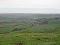
View of the village of Castleton from Mam Tor with Hope cement works in the background
-
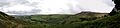
Panoramic view overlooking Hope Valley from a trail heading towards Hollins Cross
-
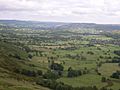
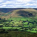
View of the Hope Valley
-
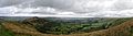
Panoramic view of the Hope Valley and Castleton
-
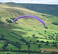
Paragliding from Mam Tor
-
View from Mam Tor looking north towards the Vale of Edale
-
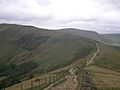
Path leading to Mam Tor from Lose Hill
-
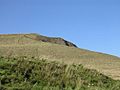
View of the summit from halfway
-
National Trust Sign


