Stanage Edge facts for kids
Quick facts for kids Stanage Edge |
|
|---|---|
 |
|
| Highest point | |
| Elevation | 458 m (1,503 ft) |
| Prominence | c. 103 m |
| Geography | |
| Location | Derbyshire / South Yorkshire |
| Parent range | Peak District |
| OS grid | SK228853 |
| Topo map | OS Landranger 110 |
Stanage Edge, often called Stanage, is a famous rocky ridge in the Peak District, England. Its name means "stone edge." This amazing place is known around the world for climbing.
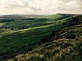
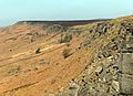
Stanage Edge is made of a type of rock called gritstone. It's like a long, steep cliff. You can find it a few miles north of a village called Hathersage. Part of the edge forms the border between Derbyshire and South Yorkshire.
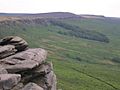
The highest point on Stanage Edge is called High Neb. It stands at 458 metres (1,503 ft) above the sea. Long ago, people dug up rocks from Stanage to make grindstones. These were big, round stones used for sharpening tools. You can still see some of these carved stones on the hillside today. They were never moved from where they were made!
A paved path for packhorses once ran along the top of Stanage Edge. Packhorses were horses used to carry goods. You can still see parts of this old path. There are also bits of the Long Causeway, which some people thought was an old Roman road. This road crosses the edge on its way from Templeborough to Brough-on-Noe. It passes an ancient marker called Stanedge Pole.
Some piles of stones, called cairns, on top of the edge are even older. There's also a well-known cave in the cliff called Robin Hood's Cave. More recently, in the early 1900s, drinking basins were built. These collected clean rainwater for grouse birds to drink.
Stanage Edge is a popular spot for many outdoor activities. It attracts climbers, hikers, and runners. The "Fat Boys Stanage Struggle" is a well-known local race. It starts in Hathersage and goes up to High Neb before returning to the village.
During the building of the Rivelin tunnel, a tall tower was built on the edge. This tower helped people survey the tunnel's path. Today, only a pile of stones remains where the tower once stood.
Contents
Rock Climbing Adventures

Stanage Edge is super famous for rock climbing in the Peak District. The rock here is called Millstone Grit. It has been shaped by nature over many years. The edge stretches for three miles from the Cowper Stone to Stanage End. It's part of a long line of cliffs, including Burbage Rocks and Froggatt Edge.
The Cowper Stone
The Cowper Stone is a large, special rock at the very south end of Stanage. It sits a bit away from the main cliff. This big boulder has cool, rounded cracks across it. In the 1980s, some very hard climbing routes were first done here. Famous climbers like Johnny Dawes and John Allen made history on these rocks.
A Century of Climbing
Interestingly, Stanage Edge was not in the first rock climbing guidebook for the Peak District. This book, Some Gritstone Climbs, came out in 1913. This was because it was hard to get permission to climb there back then. But since then, Stanage has been in many guidebooks. These books show how climbing has grown and how climbers have gotten better over the years.
Famous Routes and Achievements
Even though Stanage Edge is only about 25 metres high, it's one of the most famous climbing spots in the UK. It has tons of climbing routes and is close to a big city. One route, called Right Unconquerable (HVS 5a), is very special. When Joe Brown first climbed it in 1949, it was a huge achievement in British climbing.
Stanage Edge is also home to the longest rock route ever recorded in the UK. It's called the 5000m Girdle Traverse. Ron Fawcett completed this amazing climb in 1992. It's graded "E5 6b(ish)," which means it's incredibly difficult!
Gallery
-
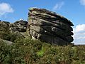
The Cowper Stone
-
-
-