
Long Causeway facts for kids
The Long Causeway, also known as Long Causey, was an old road from the Middle Ages. It was used by packhorses, which are horses that carry goods. This important route stretched between Sheffield in South Yorkshire and Hathersage in Derbyshire. For a long time, people thought parts of it were a Roman road. They believed it followed a section of an ancient Roman path called Batham Gate. However, in recent years, some experts have started to doubt this idea.

Contents
The Route
In the Middle Ages, the Long Causeway was one of three main paths leaving Sheffield towards the west. It began in an area of Sheffield called Portobello. From there, it was a seven-mile journey that climbed over 1,100 feet. The path ended at Stanedge Pole, which marked the boundary between the lands of Sheffield and Hathersage.
The route started by climbing through Leavygreave. It then crossed the top of the Crookes valley and went up Lydgate Lane. Back then, this lane was called Hallam Gate. After this, the path reached what was then open moorland. It continued through what is now Crosspool and followed the path of today's Sandygate Road and Redmires Road. The route crossed where the Redmires Reservoirs are now. Then, it faced its steepest climb up to Stanedge Pole.
From Stanedge Pole, the road began its descent towards Hathersage. It went west for half a mile. Then, it sharply turned north-west to go down Stanage Edge. This part of the path went through a less rocky area of the cliffs. The road down Stanage Edge was known for being very difficult. People recorded that cart drivers often asked passengers to get off. They would even "hang stones at the end of their carts" to help slow them down on the steep slope. After getting past the Stanage incline, the road turned almost 180 degrees. It passed Dennis Knoll and entered Hathersage from the north.
Roman Path Idea
A historian named Ivan Donald Margary, who studied Roman roads, believed the Long Causeway had a slightly different path in Roman times. He wrote in his book Roman Roads In Britain that after Redmires Reservoir, the Roman road did not follow the medieval route to Stanedge Pole. Instead, it stayed on the line of the current track to Stanedge Lodge.
He thought the Roman road then went down Stanage Edge about half a mile north-west of the current path. This Roman path was narrower and steeper. However, in 2016, a report from the University of Sheffield questioned if any Roman road existed in the Stanage Edge area. This report came from their digs of an old feature near Sheephill Road in Ringinglow.
Milestones
Even though the Long Causeway was never a "Turnpike road" (a road where you pay a toll to use it), milestones were added in the 1730s. This was because a lot of traffic used the road. It was unusual because a law from 1758 only required milestones on Turnpike roads.
One milestone was in the Sandygate area, just past Crosspool. A mile further on was an old marker called Barncliff Stoop. This stoop is still there today on Redmires Road. "Stoop" is an old word meaning a stone post. It stood near a "Barren Cliff," which is how it got its name. No one knows how old the stoop is, but it was there before the local moorland was fenced off in the 1500s. A milestone was added to the top of the stoop in 1738. This original milestone is now in Weston Park Museum. A copy now sits on top of the stoop, which is now a protected historic building.

After Barncliff Stoop, the road dipped down to the Black Brook valley. From there, you could see the next milestone on the horizon. This stone stood outside the entrance to the old Lodge Moor Hospital. It was still there in 1903 but is thought to have disappeared in the 1920s.
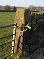
The next milestones were just east of Wyming Brook Farm. These became less important in the late 1700s when the land around them was fenced. The Causeway was also changed a bit. One of these stones is still used as a farm gatepost today. It is about 175 yards east of where Redmires Road and Soughley Lane meet. The last milestone before Stanedge Pole was on the moorland near a farm. This stone was covered when the Upper Redmires Reservoir was built in 1854. This milestone has only been seen recently when the reservoir was emptied for repairs. This happened in 1911, 1974, 2007, and 2018. The stone has "From Sheffied 6" carved into it.
Goods Carried
The Long Causeway was used a lot in the Middle Ages. Traders used packhorses to bring salt from the salt mines in Cheshire to Yorkshire. By the 1700s, carts had replaced many of the packhorses. These carts carried many different goods. This included oil, hardware, barrels of tar, large barrels of treacle, and glue from Manchester. They also carried lead and small grinding stones.
Traffic on the Long Causeway started to decrease around 1760. This was because a new route to the Hope Valley opened through Ringinglow.
Remaining Parts of the Road
Between Redmires Reservoir and Dennis Knoll car park, near Hathersage, the Long Causeway still exists. This section is about four kilometers long and is an unpaved track. It is a "Byway Open To All Traffic," meaning all types of vehicles could use it. However, the Peak District National Park has recently banned vehicles from this part.
Small areas of the track still have some paving. The longest paved section is about 80 meters long, just west of Stanage Pole. In early 2013, Derbyshire County Council did some repair work between Stanage Edge and Dennis Knoll car park. They removed many large boulders, making the surface smoother for horse riders and walkers. Many people have said this change does not fit with the old track or a National Park.
Images for kids
-
Long Causeway, milestone 5, now a field gatepost close to Wyming farm.

