
Longdendale facts for kids


Longdendale is a beautiful valley in the Peak District of England. It's located north of Glossop and southwest of Holmfirth. The name "Longdendale" means "long wooded valley," which perfectly describes the area! Most of the valley is found in the counties of Derbyshire and Greater Manchester.
Contents
Where is Longdendale?
The eastern part of the valley is in Derbyshire. Here you'll find the village of Tintwistle and part of the amazing Peak District National Park. A small bit of the valley even reaches into South Yorkshire. The western part of Longdendale includes villages like Broadbottom, Mottram in Longdendale, and Hollingworth. This area is part of Tameside in Greater Manchester. Historically, the whole of Longdendale was part of Cheshire.
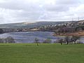
The River Etherow flows through Longdendale. This river is a branch of the River Mersey. It starts near Holmfirth and then flows through a series of six large reservoirs. These are known as the Longdendale Chain. The reservoirs are: Woodhead Reservoir, Torside Reservoir, Rhodeswood Reservoir, Valehouse Reservoir, Bottoms Reservoir, and Arnfield Reservoir. There used to be a seventh reservoir at Hollingworth, but it was closed in 1990. Now, it's part of the lovely Swallows Wood Nature Reserve.
-
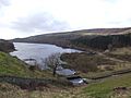
Bottoms Reservoir
-
Valehouse Reservoir
-
Rhodeswood Reservoir
-
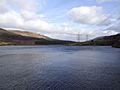
Woodhead Reservoir


Longdendale's Past
Ancient Romans in the Valley
Did you know the Romans were here? There's a small Roman fort called Highstones on a hillside overlooking Torside Reservoir. It's an oval-shaped area with a clear ditch around it, about 75 meters (82 yards) across. A walking path runs right next to it. It's thought that a Roman road might have run through the valley, connecting this fort with another Roman fort called Melandra Castle near Glossop.
Feudal Estates and Castles
Longdendale was once an old "feudal estate." This means it was a large area of land controlled by a lord in medieval times. It included several smaller areas like Godley, Hattersley, and Mottram in Longdendale. The Earl of Chester created this lordship in the late 1100s.
Buckton Castle, near Carrbrook, was probably built around the same time by William de Neville, who was the first lord of Longdendale. This castle was likely the main center of power for the lordship. One special privilege of the lord was to allow "trial by combat," where disputes were settled by a fight! The control of Longdendale changed hands many times over the centuries, often returning to the crown (the king or queen) before being granted to new families.
The Salt Trade Route

For hundreds of years, a special path called a "saltway" ran through Longdendale. This path was used by packhorses (horses carrying goods) to transport salt from towns in Cheshire like Nantwich and Northwich, across the Pennines mountains. This trade brought wealth to the villages along the route. You can still see signs of this history today, like "Salter's Brook," which is where the saltway split into different routes.
The old stone Lady Shaw Bridge still stands at Salter's Brook. It's just wide enough for a packhorse. People think it might have been wider once, but was made narrower on purpose when a toll road (turnpike) was built nearby, to stop people from avoiding the toll!
Turnpike Road
In the mid-1700s, a new toll road, or "turnpike," was built from Manchester to Saltersbrook. This road followed the old saltway route and connected to other turnpikes that led to towns in Yorkshire.
Building the Reservoirs
The Longdendale area gets a lot of rain – about 52.5 inches (1330 mm) each year! In the 1800s, a clever engineer named John Frederick Bateman saw that this water could be used to supply Manchester and Salford. He came up with a plan to build the six reservoirs we see today, which can hold a huge amount of water. A deep tunnel was also built to carry the water from Longdendale to another valley. This big project started after a special law was passed in 1847.
The Woodhead Railway Line

Between 1839 and 1845, the first railway line connecting Manchester and Sheffield was built along the south side of the reservoirs. About 1,500 workers, called "navvies," built it. Many of them got sick or even died during the tough construction. The Woodhead Tunnel, which was three miles long and had two tracks, was the longest tunnel in the country for a while! A newer, single tunnel replaced it in 1954.
The railway line eventually became too expensive to run. Passenger services stopped in 1970, and freight services (for goods) stopped in 1981. The tracks were removed in 1986. There have been ideas to reopen the railway since then, but none have happened yet.
Fun Things to Do in Longdendale
Cycling and Walking Trails
After the railway closed, the old track was removed, and the Longdendale Trail was created in its place. This trail is now part of the Trans-Pennine Trail, which is a national cycling route. It's also part of the amazing 2,000-mile European walking route E8 that goes all the way from Liverpool to Istanbul!
Longdendale is also a popular spot for the Tour de France cycling race. The Pennine Way, a famous long-distance walking path, crosses Longdendale. It comes down from Bleaklow and goes up to Black Hill. The youth hostel at Crowden is a common stop for walkers after their first day on the Pennine Way.
There's also a challenging circular walk called 'The Longdendale Edges'. It's about 17 miles long and takes you along the high ground on both sides of the valley. It's not recommended in bad weather!
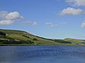
Sailing on Torside Reservoir
If you love water sports, Torside Reservoir is the place to be! It's home to the Glossop Sailing Club, where you can enjoy sailing on the water.
Getting Around Longdendale
Woodhead Pass Road
The M67 motorway starts near Manchester and currently ends at Mottram in Longdendale. In the 1960s, there were plans to extend it all the way through the National Park to Sheffield, but this never happened. From Mottram, the A628 road runs through the valley.
There have been plans to improve the A628 by building a bypass around Mottram and Tintwistle. This project is known as the Longdendale Bypass.
Rail Transport History
As mentioned, the Woodhead Line railway used to run through the valley and the Woodhead Tunnel. Even though the railway tracks were removed, the National Grid (which manages electricity) has installed cables in the newest tunnel. Some people still hope to see the railway line reopened for freight transport in the future.
How Longdendale is Governed
Longdendale has a long history of how it's been governed. Traditionally, it was part of the County Palatine of Chester. Before big changes in local government in 1974, the Longdendale Urban District and Tintwistle Rural District were part of Cheshire. The Municipal Borough of Glossop was in Derbyshire, and Penistone Rural District was in Yorkshire.
Today, the valley is split between three different areas: the Metropolitan Borough of Barnsley in South Yorkshire, the Borough of High Peak in Derbyshire, and the Metropolitan Borough of Tameside in Greater Manchester.
The Longdendale Lights
Longdendale and the areas around it are known for some strange and unexplained things! People have reported seeing mysterious lights and even supernatural ghosts. This has made the valley a popular spot for people who are interested in UFOs and ghosts. However, some scientists suggest that these lights might be "earth lights," which are natural lights produced by pressure on the rocks deep underground.
