River Etherow facts for kids
Quick facts for kids River Etherow |
|
|---|---|
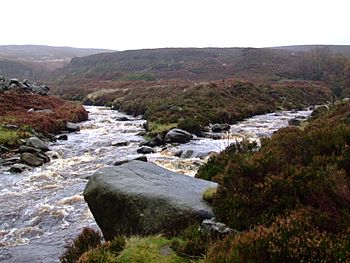
The Etherow (left), joined by the Black Cloughs from Bleaklow.
|
|
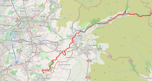
The River Etherow is highlighted in red (click to enlarge)
Coordinates: 53°27′54″N 1°58′51″W / 53.464956°N 1.980954°W |
|
| Country | England |
| Physical characteristics | |
| Main source | Featherbed Moss, South Yorkshire 500 m (1,600 ft) |
| River mouth | River Goyt 80 m (260 ft) |
| Length | 30 km (19 mi) |
| Basin features | |
| Basin size | 77.7 km2 (30.0 sq mi) |
The River Etherow is a river in northern England. It flows into the River Goyt. This river passes through South Yorkshire, Derbyshire, and Greater Manchester. Long ago, it marked the old border between Cheshire and Derbyshire. The upper part of the valley is called Longdendale. The area drained by the river is about 30 square miles (78 km2). It also gets about 52.5 inches (1,330 mm) of rain each year.
Contents
Where Does the River Etherow Flow?
The River Etherow starts in the Redhole Spring and Wike Head area. This is in Pikenaze Moor, Derbyshire. As it flows, it widens into a series of reservoirs. These are known as the Longdendale Chain. They are located in the beautiful Peak District National Park.
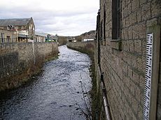
The river then reappears in Tintwistle, Derbyshire. It flows from the bottom of the Bottoms Reservoir dam. It passes by Melandra Castle in Gamesley. Here, another stream called Glossop Brook joins it.
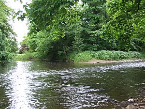
The Etherow enters Tameside in Greater Manchester at Hollingworth. It then flows into Stockport. There, it goes through Etherow Country Park. Finally, it joins the River Goyt at Brabyns Park near Marple.
Some people say the River Mersey starts where the Tame and Goyt meet. This is in central Stockport, about 4 miles (6 km) downstream. But older maps and definitions say the Mersey starts where the Etherow and Goyt join. For example, the 1911 Encyclopædia Britannica says this. An old map from 1794 shows the Mersey reaching Mottram. It also shows it forming the border between Cheshire and Derbyshire.
Animals and Plants of the Etherow Valley
The upper parts of the River Etherow flow through peat moorland. Here, you can find red foxes and voles. There are also mountain hares, which were brought to the area.
Many birds live here too. You might see red grouse, ring ouzel, wheatear, and golden plover. Kestrels, merlins, and short-eared owls make their nests in this area.
The reservoirs attract different types of ducks, like mallards and teal. You can also spot pochard, common sandpipers, black-headed gulls, and Canada geese. The nearby woodlands are home to redstart, great spotted woodpecker, and spotted flycatcher. A rare bird called a Water rail has been seen at Etherow Country Park.
How the Etherow Valley Was Formed
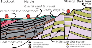
The Longdendale valley is shaped like a V and has steep sides. It was formed by glaciers long ago. This area is part of the Dark Peak. Here, a thick layer of peat covers the Millstone Grit sandstone. This sandstone formed on a bed of shale, and the Etherow flows through it.
Beneath the upper valley, you'll find rocks from the Carboniferous period. These include Millstone Grit, shales, and sandstone. The valley is on the edge of the Peak District Dome. This area was pushed up by ancient earth movements. This caused many faults (cracks in the rock). The steep valleys were carved out by glacial action. This happened during the last ice age. The glaciers used the weakened rocks to create the valleys.
The steep sides of the small valleys, called cloughs, cause a lot of erosion. This means rocks and soil are worn away. The layers of sandstone, mudstones, and shale in the ground act like a sponge. They hold water and feed the springs. The bottom of the valleys have a thin layer of boulder clay. The streams are fed by the peaty soils of the moors. This makes their water a bit acidic (pH 5.5–7.0).
A Look Back at the Etherow's History
The Etherow valley was an important path across the Pennine hills. In AD 78, the Romans built a fort called Ardotalia. This fort, later known as Melandra Castle, protected the route. Around 650 AD, the Mercians settled at Hollingworth. Many local place names, like Mottram and Glossop, come from this time.
By the time of the Domesday Book in 1086, the river was a clear border. It separated Cheshire and Derbyshire. However, the name Etherow for this part of the Mersey river only appeared around 1772.
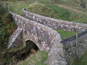
From the Middle Ages onwards, a packhorse route was used here. It was called a saltway. This path allowed salt from Cheshire towns like Nantwich to be carried across the Pennines. The saltway followed the Etherow to Ladyshaw. At Salters Brook, it split into two routes. One went to Wakefield and the other to Barnsley.
Water was very important for early industries. The Etherow and its streams flowed fast and steadily. Watermills used this power to grind meal and to process woollen cloth. Wool was brought along the turnpike road (built in 1731). This road connected towns like Ashton-under-Lyne and Sheffield. The wool was then woven into cloth on hand-looms in the valley.
From 1782 to 1820, many water-powered cotton mills were built. They were located along the streams that fed the Etherow. Six mills were on the Glossop side of the river. Later, steam power became popular for bigger mills. These mills were built closer to coal fields. The river then took on a new role. It became a source of water for the cities of Manchester and Salford.
In 1844, an engineer named John Frederick Bateman suggested something. He said the River Etherow, starting high in the Pennines, could provide clean water. This water would be collected in special reservoirs. This idea led to building the Longdendale Chain of reservoirs. It was the first project of its kind in the world. Three reservoirs were built on the Etherow to hold drinking water. Two more were built to provide water for the mills downstream.
What Does "Etherow" Mean?
The name Etherow might come from an old Celtic word, *ador. This word means "watercourse" or "channel." However, the name of the nearby village, Tintwistle, suggests something else. Etherow might have replaced an older name. This older name could be related to *Tin- (like the River Tyne). Another idea is that Etherow comes from an old English word, *edre, which means "vein."
The River Etherow's Economic Role
The Longdendale Chain of reservoirs is a big part of the local economy. It includes Woodhead Reservoir, Torside Reservoir, and Rhodeswood Reservoir. These reservoirs supply a huge amount of water every day. They send 24,000,000 imperial gallons (110 Ml) of water to Manchester and Salford. They also send 6,600,000 imperial gallons (30 Ml) to Hyde and Denton through the Mottram tunnel.
Valehouse Reservoir and Bottoms Reservoir are also part of this system. They are "compensating reservoirs." This means they release water to make up for water taken by the other reservoirs. Together, they can hold 4,200,000,000 imperial gallons (19,000 Ml) of water.
The Woodhead Railway Line
The Woodhead Line was an important railway. It followed the river from Hadfield to the Woodhead Tunnel. This line was built in 1844. It connected areas across the Pennine hills. Three tunnels, each 4,840 metres (15,880 ft) long, were dug. They linked Woodhead with Dunford Bridge on the River Don.
The railway line is now closed to trains. However, one of the tunnels is used to carry electricity cables for the National Grid. Work is being done to use a second tunnel for a new cable. This means trains cannot use the line again.
Fun Activities Along the Etherow
Walking and Cycling Adventures
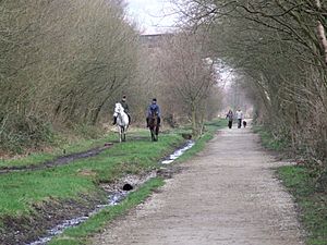
After the railway line closed, the tracks were removed. A path called the Longdendale Trail was built along the old railway route. This trail is now part of the Trans-Pennine Trail. It is also part of Sustrans National Cycle Route 62. This route is even part of the 2,000 miles (3,200 km) European walking route E8. This amazing route stretches all the way from Liverpool to Istanbul!
The Pennine Way also crosses Longdendale. It comes down from Bleaklow in the south. Then it goes up Black Hill to the north. The youth hostel at Crowden is a popular stop for walkers. It's often where people stay after the first day of walking from Edale.
There's a circular walk called 'The Longdendale Edges'. This walk takes you to the high ground on both sides of the valley. It's about 17 miles (27 km) long. It's not recommended if the weather is bad. You can find a detailed route in a guide called Peak District Walking Guide No.2.
Sailing on the Reservoirs
If you like sailing, you're in luck! Torside Reservoir is home to the Glossop & District Sailing Club. And Etherow Country Park has its own sailing club, the Etherow Country Park Sailing Club.
Exploring Etherow Country Park
Etherow Country Park, located in Compstall, is near where the Etherow joins another river. It opened in 1968. It was one of the first country parks in the UK. Before it was a park, it was an industrial area. It had a mine, a mill, and a mill pond. The River Etherow flows through the park. It is the source of water for the mill pond.
Many local groups are involved with Etherow Country Park. These include a community group called the Friends of Etherow. There are also anglers (people who fish), the sailing club, and a model boat club.
Part of the park, called Compstall Nature Reserve, is 12.8-hectare (32-acre) big. It is a special area called a Site of Special Scientific Interest (SSSI). It got this special status in 1977. This is because it has many different habitats. These include open water, tall fen (wetland), reed swamp, carr (wet woodland), and mixed deciduous woodland.
Tributaries and Route Map
The Etherow doesn't have any really big rivers flowing into it. Instead, many smaller brooks and streams feed it. These come from the cloughs (steep valleys) that flow off Kinder Scout, Bleaklow, and Black Hill.
Here are some of the smaller streams that join the Etherow from the left:
- Black Clough
- Shining Clough
- Wildboar Clough
- Torside Clough
- Glossop Brook
-
- Shell Brook
- Hurst Brook
- Gnats Hole Brook
- Chisworth Brook
- Mortin Clough
And here are some of the smaller streams that join the Etherow from the right:
- Salters Brook
- Heyden Brook
- Crowden Brook
- Hollingworth Brook
-
- Arnfield Brook
- Ogden Brook
- Gigg Brook
 | Audre Lorde |
 | John Berry Meachum |
 | Ferdinand Lee Barnett |


