
River Goyt facts for kids
Quick facts for kids River Goyt |
|
|---|---|
 |
|

The River Goyt is highlighted in red
Coordinates: 53°24′51″N 2°09′25″W / 53.41420°N 2.15689°W |
|
| Country | England |
| Physical characteristics | |
| Main source | Axe Edge Moor, Derbyshire 520 m (1,710 ft) |
| River mouth | River Mersey 40 m (130 ft) |
| Length | 48.844 km (30.350 mi) |
| Basin features | |
| Progression | Mersey—Irish Sea |
| Tributaries |
|
The River Goyt is a river in North West England. It is one of the smaller rivers that flow into the famous River Mersey. The River Goyt is about 48.8 kilometers (30 miles) long. It starts high up in the hills and flows down to join other rivers, eventually reaching the sea.
Contents
What's in a Name?
The name Goyt might come from an old English word, gote. This word meant "a watercourse" or "a stream". Some people have also suggested it comes from a Welsh word, gwyth, meaning "vein", but this idea is less likely.
Where Does the River Goyt Flow?
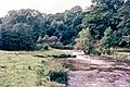
The River Goyt starts on the high moors of Axe Edge Moor in Derbyshire. This is a wild, open area near another river called the River Dane. The area where the Goyt begins is known as the Upper Goyt Valley.
As the river flows, it goes under the old Cat and Fiddle Road, which connects Buxton and Macclesfield. It then passes under Derbyshire Bridge, which used to mark the border between Derbyshire and Cheshire.
Further along its journey, the Goyt reaches an old packhorse bridge. This bridge was moved when the Errwood reservoir was built in the 1960s. A bit further downstream, you'll find another large body of water, the Fernilee Reservoir, which was built in 1938. You can even see parts of the old Cromford and High Peak Railway line nearby.
The river continues through towns like Whaley Bridge and New Mills. In New Mills, it meets another river called the River Sett. After that, it flows past Marple Bridge. Finally, after being joined by the River Etherow, the River Goyt meets the River Tame in Stockport. When the Goyt and the Tame join, they form the start of the River Mersey.
There's a special walking path called the Goyt Way that follows the river for about 16 kilometers (10 miles). It's a great way to explore the valley between Etherow Country Park and Whaley Bridge.
There's also an old story that the River Goyt is haunted by the ghost of a girl. The legend says her boyfriend, who was a Royalist soldier, drowned in the river a long time ago.
River Health: How Clean is the Goyt?
The health of a river is often checked by how clean its water is. Experts use a system to classify rivers as "good," "moderate," or "poor."
In some parts of the River Goyt, especially the lower section from the Etherow to the Mersey, the water quality was classified as "poor" in 2016. This means it wasn't as clean as it should be. The section from New Mills to Whaley Bridge was also rated "poor" in 2015. In other parts, the quality is generally "moderate," which means it's okay but could be better.
Gallery


Tributaries: Rivers Joining the Goyt
Many smaller streams and rivers flow into the River Goyt, adding to its water. These are called tributaries. Some of the main ones include:
- Todd Brook
- River Sett
- River Kinder
- River Etherow
Images for kids
-
River Goyt at Furness Vale (1968) when the colour depended on discharges from the calico print mills in the valley.
