Axe Edge Moor facts for kids
Quick facts for kids Axe Edge Moor |
|
|---|---|

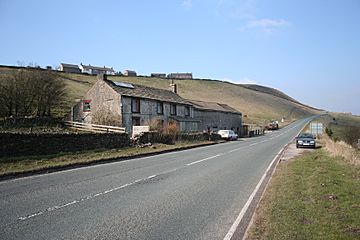
Dove Head Farm and the A53, looking towards Buxton. On the skyline are the cottages of Axe Edge End.
|
|
| Highest point | |
| Elevation | 551 m (1,808 ft) |
| Prominence | 84 m |
| Listing | Dewey |
| Geography | |
| Location | Cheshire, Derbyshire, Staffordshire, England |
| Parent range | Peak District |
| OS grid | SK035706 |
| Topo map | OS Landranger 119 |
Axe Edge Moor is a large, open area of moorland in the Peak District. It is located southwest of the town of Buxton in England. This special place is known for its unique landscape. It is also famous for being the starting point of several important rivers.
Contents
Discovering Axe Edge Moor
Axe Edge Moor is mostly made of a type of rock called gritstone. This rock formed a very long time ago from sand and mud. The highest point of the moor is 551 meters (about 1,808 feet) above sea level. This makes it a significant landmark in the area.
Where is Axe Edge Moor?
The moor is shared by three different counties in England. These are Derbyshire, Staffordshire, and Cheshire. The point where these three counties meet is called Three Shire Heads. This spot is on the southwestern side of the moor, near the River Dane.
The Rivers of Axe Edge
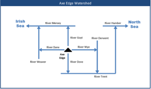
Axe Edge Moor is often called the "watershed" of the Peak District. This means it's where many rivers begin their journey. The moor is the source of five important rivers:
- The River Dove
- The River Manifold
- The River Dane
- The River Wye
- The River Goyt
These rivers flow in different directions across the landscape. They provide water to many towns and cities.
High Points and Pubs
The area known as "Axe Edge" itself is on the southeastern edge of the moor. It is close to where the River Dove starts.
The moor is also home to a very famous building. This is the Cat and Fiddle Inn. It is England's second-highest public house. This means it is one of the highest pubs in the country that is open to everyone.
 | Selma Burke |
 | Pauline Powell Burns |
 | Frederick J. Brown |
 | Robert Blackburn |


