
River Tame, Greater Manchester facts for kids
Quick facts for kids Tame |
|
|---|---|

River Tame near Reddish Vale
|
|

The River Tame is highlighted in red
Coordinates: 53°24′51″N 2°09′25″W / 53.4142°N 2.15689°W |
|
| Native name | Para |
| Country | England |
| Region | Greater Manchester |
| Physical characteristics | |
| Main source | west of Buckstones Moss, West Yorkshire 473 m (1,552 ft) 53°37′07″N 2°00′13″W / 53.6187°N 2.0035°W |
| River mouth | River Mersey Stockport 40 m (130 ft) 53°24′51″N 2°09′23″W / 53.4143°N 2.1565°W |
| Length | 47.7 km (29.6 mi) |
| Basin features | |
| River system | River Mersey |
| Basin size | 146 km2 (56 sq mi) |
The River Tame flows through Greater Manchester, England. It starts high up on Denshaw Moor and travels to Stockport. There, it meets the River Goyt to create the famous River Mersey.
Contents
Journey of the River Tame
Most of the River Tame's water comes from the western side of the Pennines, a range of hills. The river officially begins with water released from the Readycon Dean Reservoir in the moors above Denshaw. This water is called "compensation flow," meaning it's a guaranteed amount of water released to keep the river flowing.
The true source of the river is a bit further north, just over the border in West Yorkshire. It's close to the Pennine Way, a long walking path. The highest point where the river's water collects is Black Chew Head, which is also the highest point in Greater Manchester.
The River Tame generally flows south. It passes through several towns like Delph, Uppermill, Mossley, Stalybridge, Ashton-under-Lyne, Dukinfield, Haughton Green, Denton, and Hyde.
The Division Bridge in Mossley is a special spot. It marks where the old borders of Lancashire, Yorkshire, and Cheshire used to meet. The river section in Stalybridge was once considered for a new path for the Huddersfield Narrow Canal, but the canal ended up using a different route. Finally, the Tame joins the River Goyt in Stockport to form the River Mersey.
River Pollution and Cleanup
In the 1800s, many factories and towns grew along the River Tame. This caused a lot of pollution. Waste from textile mills (like dyes and bleaches), paper factories, and engineering plants flowed into the river. Even chemicals from battery making and coal-gas plants added to the problem. On top of that, sewage from homes also ended up in the river. At one point, up to two-thirds of the river's water had passed through a sewage treatment plant before it joined the Goyt.
Luckily, a lot of effort has been made in the last 30 years to clean up the river. These efforts have been very successful, and now many different types of fish and other animals can live in the Tame again. Scientists from the Centre for Ecology and Hydrology measure the river's flow at places like Portwood weir in Stockport and Broomstairs weir in Denton. This helps them keep track of the river's health.
Historical Border
The River Tame has been an important boundary for a very long time. In ancient times, it marked the border between the Anglo-Saxon kingdoms of Northumbria and Mercia. After the Division Bridge in Mossley, the river continued to serve as much of the historical boundary between Cheshire and Lancashire.
Where the River Ends

The River Tame meets the River Goyt in Stockport. When these two rivers join, they create the River Mersey. The Mersey then flows all the way to the Irish Sea, passing by the city of Liverpool on its way.
Meaning of the Name
The name Tame is found in several river names across the UK, like the Thames and Tamar. The name comes from an ancient Celtic language, but its exact meaning is not certain. Some people think it might mean "dark river" or "dark one." However, it could simply mean "river," similar to how the name Avon also means "river."
The Metropolitan Borough of Tameside is named after the river. Even though the river doesn't start or end within the borough's exact borders, a large part of the towns and cities along the river are located in Tameside.
River Wildlife: Fish and Other Animals
The types of fish living in the River Tame change depending on where you are along its length.
- In the lower parts of the river, near Reddish Vale Country Park, you can find "coarse fish." These include fish like gudgeon, chub, and roach. Larger fish like pike and perch are also present.
- Further upstream, above Ashton, you'll find brown trout and smaller numbers of coarse fish. These fish populations are able to reproduce and keep their numbers healthy on their own.
Unfortunately, migratory fish like Atlantic salmon and Sea-trout cannot travel up the River Tame. This is because the weir (a small dam) at Reddish Vale is too tall, and there isn't a special "fish pass" to help them get over it.
Several smaller streams that flow into the Tame are officially protected as "salmonid waters." This means they have strict rules about how clean their water must be to support fish like salmon and trout. These streams include:
- Carr Brook
- Diggle Brook
- Hull Brook
- Swineshaw Brook
- And parts of the Tame itself.
Hull Brook is especially important and is called a Site of Biological Importance (SBI). Both Hull Brook and Castleshaw Reservoir are home to white-clawed crayfish, which are a protected species. The river is now clean enough for otters to live there, but a survey in the early 2000s didn't find any.
Environment and Microplastics
In 2018, a study found that the River Tame had the highest amount of microplastic pollution of any river that had been studied up to that point. Microplastics are tiny pieces of plastic that can harm wildlife and the environment. This shows that even though the river is much cleaner than it used to be, there are still environmental challenges to address.
Tributaries of the River Tame
Many smaller streams and brooks flow into the River Tame along its journey. These are called tributaries. Some of the main tributaries include:
- Denton Brook
- Gower Hey Brook
- Swineshaw Brook
- Staly Brook
- Carr Brook
- Quick Brook
- Chew Brook
- Diggle Brook
- Hull Brook
- Coal Brook
- Rams Brook
- Dowry Water
- Readycon Dean Brook
Images for kids
-
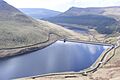
Greenfield Reservoir
-
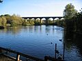
Railway viaduct and former lodge at Reddish Vale


