
Stalybridge facts for kids
Quick facts for kids Stalybridge |
|
|---|---|
 View over Stalybridge |
|

Stalybridge
|
|
| Population | 23,731 (2011 Census) |
| OS grid reference | SJ963985 |
| Metropolitan borough | |
| Metropolitan county | |
| Region | |
| Country | England |
| Sovereign state | United Kingdom |
| Post town | STALYBRIDGE |
| Postcode district | SK15 |
| Dialling code | 0161 / 01457 |
| Police | Greater Manchester |
| Fire | Greater Manchester |
| Ambulance | North West |
| EU Parliament | North West England |
| UK Parliament |
|
Stalybridge (/ˌsteɪliˈbrɪdʒ/) is a town in Tameside, Greater Manchester, England. In 2011, about 23,731 people lived there.
Historically, Stalybridge was split between Cheshire and Lancashire. It is about 8 miles (13 km) east of Manchester. It is also 6 miles (10 km) north-west of Glossop.
In 1776, a cotton mill that used water power was built. This made Stalybridge one of the first places to make textiles during the Industrial Revolution. The money made from cotton factories in the 1800s changed the area. It went from scattered farms to a busy town.
Contents
History of Stalybridge
Early Times
The oldest signs of people in Stalybridge are from the late Neolithic (New Stone Age) or early Bronze Age. These include a flint scraper. There are also two ancient stone piles called cairns on Hollingworthall Moor. One of these round cairns is the best-preserved Bronze Age site in Tameside. It is now a protected monument. A Roman road is thought to have passed through Stalybridge. This road connected the Roman forts at Manchester (Mamucium) and Melandra Castle (Ardotalia).


The town was first called Stavelegh. This Old English name means "wood where the staves are got." The medieval Lords of the manor used de Stavelegh as their name. Later, it became Stayley or Staley. The area of Stalybridge was part of the ancient feudal lands of Longdendale in Cheshire. Buckton Castle, near Stalybridge, was likely built by an Earl of Chester in the 1100s. The manor of Staley was first mentioned between 1211 and 1225.
The first records of the de Stavelegh family as Lords of the Manor of Staley are from the early 1200s. Staley Hall was their home. The current hall was built in the late 1500s. It stands where an older hall from before 1343 once stood.
Sir Ralph Staley had no sons, only a daughter named Elizabeth Staley. She married Sir Thomas Assheton. This joined the lands of Ashton and Staley. Elizabeth and Thomas had two daughters. Margaret, the older daughter, married Sir William Booth. The younger daughter, Elizabeth, lived at Staley Hall until she died in 1553. She left her share of the lands to the Booth family.
The Booth family owned the manor of Staley until 1758. Then, Lady Mary Booth inherited all the Booth estates. She was the wife of Harry Grey, 4th Earl of Stamford. The Grey family owned the manor of Staley until 1976. Many places in Stalybridge are named after the Grey family. These include Stamford Street and Stamford Park.
The Industrial Revolution
As Stayley grew in the 1700s, it reached the River Tame. A bridge was built in 1707. After this, the settlement was called Stalybridge, meaning the bridge at Stayley. By the mid-1700s, Stalybridge had only 140 people. Farming and spinning wool were the main jobs.

In 1776, the town's first water-powered mill was built. It was used for preparing and spinning cotton. In 1789, the first spinning mill using Arkwright's Water Frame was built. By 1793, steam power was used in the cotton industry. By 1803, there were eight cotton mills in the town. The Huddersfield Narrow Canal was finished in 1811. It still runs through Stalybridge today.
New machines caused the industry to grow quickly. But some people were against this. The Luddites came to the area. Mill doors were kept locked day and night. Mill owners asked for military help. A Scottish regiment was sent to the town. Groups of armed men destroyed machines and attacked mills. There was a night of rioting on April 20, 1812.
This unrest did not stop Stalybridge from growing. By 1814, there were twelve factories. By 1818, there were sixteen. The Industrial Revolution caused the town's population to grow fast. By 1823, the population was 5,500. In the next two years, it grew to 9,000. Many Irish families moved there for better jobs. Stalybridge was one of the first towns to open a Mechanics' Institute. This was to educate the growing number of workers. It opened in 1825.
On May 9, 1828, Stalybridge became an independent town. It had a board of 21 Commissioners. The Stalybridge Town Hall opened on December 30, 1831. In 1833, the Commissioners started the Stalybridge Police Force. It was the first of its kind in the country. By this year, the town's population was 14,216.
In 1834, a second bridge was built over the Tame. It was made of iron.
In April 1842, the second Chartist petition was given to Parliament. Stalybridge added 10,000 signatures. After the petition was rejected, the first general strike started. This strike, also called the Plug Riots, spread across Britain. It involved nearly half a million workers. On August 13, 1842, workers at Bayley's Cotton Mill in Stalybridge went on strike. They then stopped work at other mills in the area. The workers wanted their wages from 1820 back. They also wanted a ten-hour workday.
Friedrich Engels wrote about Stalybridge in his book The Condition of The Working Class in England (1844). He said the town had many crowded courts and lanes. He also mentioned the "shocking filth."
John Summers started an iron forge in Stalybridge in the 1840s. Later, his business grew. It employed over 1,000 local men.
The railway came to Stalybridge on October 5, 1846. Later, in 1849, Stalybridge was connected to Huddersfield and Stockport by another railway line.
The Cotton Famine
When the American Civil War began in 1861, Stalybridge cotton mills quickly ran out of cotton. Thousands of workers lost their jobs. By the winter of 1862–63, 7,000 people were unemployed. Only five of the town's 39 factories were still working full-time. People from all over the world sent money to help the cotton workers. At one point, three-quarters of Stalybridge workers relied on relief programs. By 1863, there were 750 empty houses. A thousand skilled workers left the town. This was called "The Panic."
In 1863, the relief committee decided to give out tickets instead of money. These tickets could be used at local shops. This led to organized resistance. It ended in a riot on March 20, 1863.

In 1867, the Victoria Bridge on Trinity Street was built. Victoria Market Hall was built in 1868. The public baths opened in May 1870. These baths were a gift to the town from Robert Platt and his wife Margaret.
Stalybridge Borough Band was formed in March 1871. The band was known as the 4th Cheshire Rifleman Volunteers until 1896.
The 1900s
The cotton industry was still strong at the start of the 1900s. The town's population reached its highest in 1901, with 27,623 people. But as trade decreased, the population began to fall. Even with more jobs during the war years, the cotton industry continued to struggle.
There were floods in Millbrook in May 1906.


Mrs Ada Summers was elected the first woman mayor of Stalybridge in November 1919. She became the first woman magistrate in the country. She was sworn in on December 31. Ada Summers used her wealth to help the town. She supported clinics for mothers and children. She also helped set up an employment center. She later received the MBE award.
In 1929, the Summers iron plants moved to Shotton in North Wales. This caused many job losses in Stalybridge. By 1932, seven of the town's largest mills had closed. Unemployment reached 7,000 people. In 1934, the council started a committee to bring new industries to the town. They bought Cheetham's Mill and rented it to small businesses. By 1939, unemployment had almost disappeared.
1939 to 2000
Stalybridge had black-out periods and air-raid warnings during World War II. Bombs mostly landed in open areas, and no civilians were hurt. On July 19, 1946, King George VI and Queen Elizabeth visited Stalybridge. The town's war memorial was updated in 1950. It added the names of 124 more men.
After the war, the council built new homes. The Buckton Vale estate was built from 1950 to 1953. The Stamford Park estate was built from 1953 to 1955. The Copley estate started in 1954.
In 1955, old housing was replaced with new estates. Empty textile mills were used by light industries. New types of engineering, rubber goods, plastics, and chemicals were introduced. Synthetic fibers were added to the textile trade. This helped reduce unemployment.
In the early 1970s, new private homes were built. These were in areas like Mottram Rise and Carrbrook. The Castle Hall area was also redeveloped.
In the early 1980s, the public baths closed. They were later torn down.
In 1991, Stalybridge's population increased to 22,295. This was the first increase since 1901. The 1990s saw many new homes built in a Mock Tudor style. This continued into the 2000s.
The 2000s

The Huddersfield Narrow Canal was restored between 1999 and 2001. It now runs through the town center. The canal goes under the legs of an electricity pylon.

The market hall closed in 1999. It became the Civic Hall in 2001. The town's cinema, the Palace, closed in 2003. It later became a nightclub and bar.
In 2004, the council allowed 16 homes to be built next to Staley Hall. The hall had to be restored as part of the plan. By 2015, Staley Hall was renovated and turned into apartments.
Stalybridge was affected by Storm Angus in November 2016. About 3 inches (8 cm) of rain fell in five hours. Roads in Millbrook were flooded.
In June 2018, a large wildfire from Saddleworth Moor threatened many homes. 50 homes in the Carrbrook area were evacuated.
In December 2023, during Storm Gerrit, a tornado caused damage in the Millbrook and Carrbrook areas.
How Stalybridge is Governed
Town's History of Government

.JPG)
Stalybridge became a Municipal Borough on March 5, 1857. It was formed from parts of Ashton-under-Lyne, Dukinfield, and Stayley parishes. The council was made up of a Mayor, 6 Aldermen, and 18 Councillors. The Borough was divided into three areas: Lancashire, Staley, and Dukinfield. The first election for councillors was held on May 1, 1857. The council met on May 9 and elected William Bayley as the first Mayor.
Stalybridge received its own Coat of Arms. These arms included symbols from the Stayley, Assheton, Dukinfield, and Astley families. These families had owned land in the town. The town's motto, absque labore nihil, means "nothing without labour."
In 1889, Stalybridge was placed entirely within the county of Cheshire. This was under the Local Government Act 1888. Cheshire also became the postal county for the whole town.
On April 1, 1936, Stalybridge grew larger. It gained part of Matley parish.
In 1955, Stalybridge became twinned with Armentières, France. In 1974, Stalybridge joined with other districts to form the Metropolitan Borough of Tameside. Stalybridge is now represented by nine councillors on the Tameside Council. These councillors meet every two months as the Stalybridge District Assembly.
Representing Stalybridge in Parliament

Before 1832, Cheshire was represented by two Knights of the Shire in Parliament. After the Great Reform Act of 1832, the southern part of Stalybridge was included in the North Cheshire area.
From 1867 to 1918, Stalybridge had its own Member of Parliament. This was through the Stalybridge Borough constituency. Since 1918, the town has been represented by the Member for the Stalybridge and Hyde area. The current Member of Parliament is Jonathan Reynolds.
Geography of Stalybridge

Stalybridge is located in the foothills of the Pennines. It sits across the River Tame. The river marks part of the old border between Lancashire and Cheshire. The town is on the edge of the Peak District National Park. The highest point in Stalybridge is Wild Bank, at 1,309 feet (399 m). Harridge Pike is the second highest peak. Buckton Hill, where the medieval Buckton Castle stood, is another important landmark. The town center is along the river, between Ridge Hill to the north and Hough Hill to the south.
The population of Stalybridge decreased during the 1900s. This was after older, crowded housing was removed. In 2001, Stalybridge had 22,568 people. The town includes areas like Heyheads, Buckton Vale, Carrbrook, Millbrook, Brushes Estate, Copley, and Matley.
 |
Ridge Hill | Mossley | Saddleworth | |
| Ashton-under-Lyne | Saddleworth Moor | |||
| Dukinfield | Hyde | Mottram in Longdendale |
People of Stalybridge
| Stalybridge | |||
|---|---|---|---|
| 2001 UK census | Stalybridge | Tameside | England |
| Total population | 22,568 | 213,043 | 49,138,831 |
| White | 97.1% | 91.2% | 91% |
| Asian | 1.9% | 5.6% | 4.6% |
| Black | 0.1% | 1.2% | 2.3% |
In 2001, Stalybridge had a population of 22,568. There were 100 females for every 95 males. About 29.2% of people over 16 were single. 41.6% were married. Stalybridge had 9,331 households. These included 29.1% one-person households. 38.3% were married couples living together. About 31.7% of people aged 16–74 had no academic qualifications.
Population Changes Over Time
| Population change in Stalybridge since 1823 | |||||||||||||
|---|---|---|---|---|---|---|---|---|---|---|---|---|---|
| Year | 1823 | 1825 | 1901 | 1911 | 1921 | 1931 | 1939 | 1951 | 1961 | 1971 | 1991 | 2001 | 2011 |
| Population | 5,500 | 9,000 | 27,673 | 26,513 | 25,213 | 24,831 | 22,299 | 22,541 | 21,947 | 22,799 | 22,921 | 22,568 | 23,731 |
| Source: | |||||||||||||
Nature and Parks

Many of the higher areas of the town are grouse moors. Boar Flat is a special scientific area. The slopes below the moors are used for sheep grazing. Stalybridge Country Park has two main areas. First, the Brushes Valley, with its four reservoirs. Second, Carrbrook, near Buckton Castle. These areas are connected by paths. Visitors can explore the Tame Valley and the Peak District. The country park offers views of the Cheshire Plain. On clear days, you can see the mountains of Snowdonia. Buckton Castle and Stalybridge cairn are protected monuments.

The town's two parks are important open spaces. Cheetham Park opened in June 1932. John Frederick Cheetham left the park to the town. He also left his house, Eastwood, and his art collection. The art collection is now in the Astley Cheetham Art Gallery. The park has woodlands. Next to Cheetham's Park is the Eastwood Nature Reserve. This reserve is managed by Cheshire Wildlife Trust. It has bog plants like sphagnum mosses. Nine types of dragonfly and damselfly have been seen there. The reserve is 4.7 hectares (12 acres) in size.

Stamford Park is a special place. In 1865, local mill owner Abel Harrison died. His home and land were bought by Stalybridge and Ashton. George Harry Grey donated more land. The whole area became Stamford Park. It opened in 1873. A former mill reservoir was added to the park in 1891. It was divided into two. The southern part became the boating lake. The park has tennis courts and bowling greens. It also has a children's playground. The park hosts the annual Tulip Sunday Festival.
Culture in Stalybridge
Music Scene
Stalybridge has a strong music history. Stalybridge Old Band was formed in 1809. It might be the first civilian brass band in the world. Carrbrook Brass also represents the town. An annual brass band contest is held in the town on Whit Friday. This has happened since at least 1870. Bands travel from all over the UK to compete.

The song It's a Long Way to Tipperary was created in Stalybridge. The composer, Jack Judge, wrote it in 1912. He was challenged to write a song in one night. He first sang it in public on January 31, 1912. A memorial tablet was put up in 1953 where the song was composed. Jack Judge is also remembered with a statue.
Recently, live folk music has become popular. The Buffet Bar Folk Club meets every Saturday. The Free and Easy folk club meets on alternate Thursdays. Some members of the Fivepenny Piece band were from Stalybridge. They sang traditional North Country music in the 1970s. They performed songs like "Stalybridge Station."
Art and Creativity

The Astley Cheetham Art Gallery was a gift to Stalybridge. It was given by John Frederick Cheetham and his wife. It opened in 1901 as a lecture theatre. It became a gallery in 1932 to hold the Astley Cheetham Collection. This collection has many 15th-century Italian paintings. It also has British art from the 1800s and 1900s. Artists like J. M. W. Turner are featured. The gallery also shows art by local artists.
The painter L. S. Lowry captured Stalybridge in his art. Some of his paintings show the people of Stalybridge. Lowry continued painting until he died in 1976. His house has a blue plaque on Stalybridge Road. There is also a statue of him. Sheila Vaughan is a Stalybridge artist. Her work is shown at the Peoples Gallery.
The Lock Gates Sundial is a large piece of public art. It is next to the canal in Armentieres Square. It was put up in 2008 to celebrate the canal's reopening.
Books and Stories
Stalybridge was mentioned in Disraeli's novel Coningsby. The children's author Beatrix Potter visited Gorse Hall many times. It was her grandmother's home. Samuel Laycock (1826–93) was a librarian at the Mechanics' Institute. His poems show what working-class life was like in the mid-1800s. His most famous poems are "Bowton's Yard" and "Bonny Brid." Both were written in Stalybridge. Tim Willocks, a well-known author, is from Stalybridge. Dolores Gordon-Smith, who writes mystery novels, is also from Stalybridge.
Local Traditions
Whit Friday
Whit Friday is the first Friday after Whitsun. It is important in Stalybridge for the annual Whit Walks. It is also the day for the traditional brass band contests.
Wakes Week
The wakes were originally religious festivals. During the Industrial Revolution, they became a summer break for mill towns. Each town had a "wakes week" when all cotton mills closed. Stalybridge Wakes is in the third week of July. Wakes Week became a time for fairs and holidays. Mill workers would travel to the seaside.
Food and Drink
Stalybridge has a public house with a very long name: The Old Thirteenth Cheshire Astley Volunteer Rifleman Corps Inn. It also has one with the shortest name: Q. The railway station has one of the last original buffets in Britain.
The canal was restored from 1999 to 2001. This brought new cafes and boat trips. Because the canal and river run through the town, Stalybridge is sometimes called "Little Venice". Stalybridge also has the nickname "Staly Vegas". This name became popular after many nightclubs and bars opened.
Traditional foods include Tater Hash (Potato Pie) and black peas. Black peas are mostly eaten on Whit Friday. Stalybridge has the region's last remaining tripe shop.
Media and News
The Stalybridge Reporter newspaper started in 1855. It now serves the wider area as The Tamesider Reporter. The Tameside Advertiser is a free weekly newspaper. It started in 1979.
Local news and TV shows are from BBC North West and ITV Granada. Radio stations include BBC Radio Manchester and Tameside Radio.
Stalybridge on Screen
The town has been used for filming movies and TV shows. The movie Yanks (1979) was filmed here. It starred Richard Gere. The opening scene shows Stalybridge War Memorial. The US army camp scenes were filmed at Stamford Golf Club.
In 1986, the BBC children's TV series Jossy's Giants was filmed in Stalybridge. In 2009, the BBC3 show We Are Klang was filmed at Victoria Market Hall. Scenes from Coronation Street and The League of Gentlemen have also been shot here.
Town Facilities

NatWest has a bank branch on Melbourne Street. Stalybridge Post Office is on Trinity Street. There are also smaller post offices at Ridge Hill and Carrbrook. The police station is on Waterloo Road. The fire station is on Rassbottom Street. Stamford Park offers green space and facilities.
Getting Around Stalybridge
Road Travel
The closest motorway is about 1 mile (1.6 km) from the town. It is junction four of the M67. The M67 connects to the M60 Manchester orbital motorway. The A635 road goes through the town. The A6018 starts in Stalybridge.
Train Travel
Stalybridge railway station is on the route from Liverpool to Leeds. TransPennine Express trains run through Stalybridge. They connect Liverpool, Leeds, and other places in north-east England.
The Stockport to Stalybridge Line only has two trains on Saturday mornings. This is to keep the stations Reddish South and Denton open.
Bus Travel

Stalybridge bus station is managed by Transport for Greater Manchester. Most buses are run by Stagecoach Manchester. Other companies also operate buses. There are frequent buses to Ashton-under-Lyne. Buses also go to Glossop, Hyde, Manchester, Oldham, and Saddleworth.
Tram Services
A tram network ran through Stalybridge from 1904 to 1945. It was replaced by buses. The modern Manchester Metrolink tram system stops at nearby Ashton-under-Lyne.
Canal Routes

The Huddersfield Narrow Canal passes through Stalybridge. It is part of the South Pennine Ring. The canal connects Huddersfield to Ashton-under-Lyne. It was finished in 1811. It closed in 1951 but reopened in 2001. The Canal and River Trust now manages it.
Sports in Stalybridge

From the late 1800s until 1909, the main football team was Stalybridge Rovers. Today, the town's team is Stalybridge Celtic. They were founded in 1909. They play in the Northern Premier League Division One West.
There are two main cricket clubs. Stayley C.C. plays in Millbrook. Stalybridge St Paul's C.C. plays on Cheetham Hill Road.

Stamford Golf Club has an 18-hole course. It was started in 1901. It is named after the local landowner, the Earl of Stamford.
Priory Tennis Club is next to Cheetham's Park. It has four tennis courts with lights. The club is part of the Lawn Tennis Association.
The local athletics club is East Cheshire Harriers. It was founded in 1922. Its home is now the Richmond Park Stadium in Ashton-under-Lyne.
A snooker league runs from October to May each year.
There are two crown green bowling clubs. One is in Stamford Park. The other is at Carrbrook village.
In 1901, Joey Nuttall from Stalybridge set a new world swimming record. He swam a quarter-mile in 5 minutes 38 seconds. Stalybridge has a 25-meter pool at Copley Recreation Centre. It is home to the Stalybridge Amateur Swimming and Water Polo Club.
In 2006, Stalybridge-born cyclist Hamish Haynes won the UK National Road Race Championship.
Places of Worship
Before the 1700s, Stalybridge was part of the parish of St Michael and All Angels, Mottram. The first church built in Stalybridge was Old St George's Church. It was consecrated in 1776 but collapsed in 1778. After the Industrial Revolution, many different religious groups came to Stalybridge.
The first Methodist chapel was built in 1802. The Baptist chapel on King Street opened in 1828.
Churches in Stalybridge

- Church of England
St George's is the parish church on the Lancashire side of the river. It is also called New St George's. Its foundation stone was laid in 1840. On the Cheshire side, Holy Trinity and Christ Church is on Trinity Street. The foundation stone of St Paul's, Staley, was laid in 1838. It is an active church today.
-
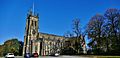
St Paul's Church
-
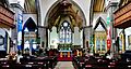
Inside St Paul's Church


- Roman Catholic
There are two Roman Catholic parishes. St Peter's, Stalybridge, started in 1838. St Raphael's, Millbrook, was closed in 2011 due to repair costs.
- Methodist
The octagonal Stalybridge Methodist Church on High Street opened in 1966.
-
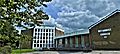
Stalybridge Methodist Church
-
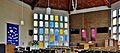
Inside Stalybridge Methodist Church


- Congregationalist
Stalybridge Congregational Church is in a modern building on Baker Street. Its original building was built in 1861.
- Unitarian
The Unitarian Church on Forester Drive was built in 1870.
- Evangelical/Non-denominational
Stalybridge Revival Church is on Mount Street. It was started in 2009.
Schools in Stalybridge

Before 1910, primary schools were run by churches. In 1910, the town opened its own school on Waterloo Road. West Hill School for boys opened in 1927. The central school for girls opened in 1930. Until 1980, secondary modern schools were in the town. Grammar school education was at Hyde Grammar School.
In 1977, the local education authority tried to keep its grammar schools. But after a new council was elected in 1980, the grammar schools were closed. All secondary schools in Stalybridge, Hyde, and Dukinfield became comprehensive schools.
Primary Schools
- Stalyhill Junior School
- Gorse Hall Primary School
- Arlies Primary School
- Silver Springs Primary Academy (formerly Ridge Hill)
- Wild Bank Community School
- St Peter's RC Primary School and Nursery
- St Paul's C of E Primary School
- St Raphael's RC Primary School
- Buckton Vale Primary School
- Millbrook Primary School
- Trinity Christian School (a private Christian school)
Secondary Schools
- Copley Academy (formerly Copley High School) for ages 11–16
- West Hill School for boys aged 11–16
- All Saints' Catholic College for ages 11–18. It is in Dukinfield but serves Stalybridge.
- Trinity Christian School (a private Christian school)
See also
 In Spanish: Stalybridge para niños
