
Glossop facts for kids
Quick facts for kids Glossop
|
|
|---|---|
 |
|

Glossop
|
|
| Population | 17,825 (2021 Census) |
| OS grid reference | SK0393 |
| District |
|
| Shire county | |
| Region | |
| Country | England |
| Sovereign state | United Kingdom |
| Post town | GLOSSOP |
| Postcode district | SK13 |
| Dialling code | 01457 |
| Police | Derbyshire |
| Fire | Derbyshire |
| Ambulance | North West |
| EU Parliament | East Midlands |
| UK Parliament |
|
Glossop is a busy market town in Derbyshire, England. It's about 15 miles (24 km) east of Manchester. Glossop is often called the "Gateway to the Peak District" because it's right next to the beautiful Peak District National Park. In 2021, about 17,825 people lived here.
Long ago, Glossop was just a small village. Its name comes from an old parish mentioned in a very old book called the Domesday Book from 1086. Later, it became a "manor," which was a large area of land controlled by a lord. The land was given by King William I to William Peverel.
Glossop grew very quickly in the late 1700s. It became famous for making and printing calico, a type of cotton cloth. It was a "mill town" with many churches and chapels. The town's success was closely tied to the cotton industry. Many buildings in Glossop are made from local sandstone. Some of these, like the old Glossop Gasworks, are special historic buildings. You can still see two large former cotton mills and the impressive Dinting railway viaduct.
Contents
- History of Glossop: A Journey Through Time
- How Glossop is Governed
- Geography: Where is Glossop?
- Demography: How Many People Live in Glossop?
- Economy: What Jobs are in Glossop?
- Landmarks: Famous Places in Glossop
- Transport: Getting Around Glossop
- Leisure: Things to Do in Glossop
- Schools and Learning
- Sport: Glossop's Sporting Spirit
- Culture: Arts and Events
- Emergency Services
- Twin Town: Friends Across the Sea
- Literature and Media: Glossop in Stories
- Notable People from Glossop
- Images for kids
- See also
History of Glossop: A Journey Through Time
What's in a Name? The Meaning of Glossop
The name Glossop probably comes from the Angles, who settled here in the 600s. It might mean "Glott's Valley," where "Glott" was a leader's name. The word "hop" could mean a small valley or an area of land surrounded by wet ground. The original village of Glossop is now called Old Glossop. Over time, other areas like Howard Town grew bigger and became known as Glossop.
Ancient Times: Romans and Early Settlers
People have lived in this area for a very long time! There's evidence of a Bronze Age burial site on Shire Hill, near Old Glossop. The Romans arrived in 78 AD. They built a fort called Ardotalia (also known as Melandra Castle) on high ground above the river in what is now Gamesley. This fort was found again in 1771. You can still visit the site today, which has been made easy for visitors with parking and picnic spots.
Medieval Period: Monks, Markets, and Dukes
In 1157, King Henry II gave the land of Glossop to Basingwerk Abbey, a monastery. The monks helped Glossop get a special permission to hold a market in 1290. This made Glossop a market town. Later, in 1433, the monks leased the land to the Talbot family.
A member of the Talbot family, Dr. John Talbot, became the vicar of Glossop in 1494. He started a school and paved a path over the moors, which is still known as Doctor's Gate. When monasteries were closed down in 1537, the Glossop land went to the Talbot family. In 1606, it was taken over by the Howard family, who were the Dukes of Norfolk. They owned the land for 300 years!
The land around Glossop was too wet for growing wheat, but it was perfect for tough Pennine sheep. So, farming here was mostly about raising animals. Most of the land was leased from the Howards. Houses were built strongly from local stone, which helped people start home businesses like spinning and weaving wool.
Industrial Revolution: Cotton Mills and Big Changes

The Middle Ages economy was based on sheep and wool. But during the Industrial Revolution in the 1700s, Glossop became a major center for spinning cotton. Cotton was brought from Liverpool to Glossop. The local workers already knew how to spin wool, so they quickly learned cotton. Glossop also had lots of soft water to power the mills and a humid climate, which was great for spinning cotton.
The Rise of Glossop's Mills
The first mills in Glossop were for wool. But in 1774, Richard Arkwright opened a cotton mill and developed the "factory system." He invented machines for spinning and carding cotton. After his patents ended in 1785, many people copied his ideas. By 1788, there were over 200 Arkwright-style mills in Britain, and 17 of them were in Derbyshire, mostly in Glossop.
By 1831, Glossopdale had at least 30 mills. Many mill owners were local families like the Woods, Sumners, and Sidebottoms. In 1825, John Wood brought the first steam engine and power looms to Glossop. Soon, other big mills like Wren Nest, Howardtown, and Waterside became huge "vertical combines." This meant they did everything from spinning the yarn to weaving the cloth. These large mills made Glossop famous for its calico. The Glossop Tramway opened in 1903 to help workers get to the different mills.
Edmund Potter's calico printing factory in Dinting Vale was huge. In the 1850s, it printed 2.5 million pieces of cloth, with 80% of it sent to other countries. The paper industry also grew thanks to Edward Partington. He bought Turn Lee Mill in 1874 to make high-quality paper from wood pulp. His factories in Charlestown created almost 1,000 jobs.
Community and Kindness


The 12th Duke of Norfolk helped Glossop a lot. He rebuilt the old parish church in 1831, built All Saints Roman Catholic chapel in 1836, and improved the Hurst Reservoir. He also built a primary school and the Town Hall, which opened in 1845.
The railway came to Dinting in 1842. The 13th Duke of Norfolk built a special railway line to Howard Town so coal could be brought in. The Glossop railway station still has the lion symbol of the Norfolk family. Many street names in Glossop come from the Dukes of Norfolk.
Mill owners, whether Catholic, Anglican, Methodist, or Unitarian, built reading rooms and chapels. They often worked and worshipped together with their employees. They built many churches and chapels, showing how important faith was in the community.
There was a friendly rivalry between Edward Partington and the Woods and Sidebottoms families. The Woods built public baths and a park. Partington built the library and the cricket pavilion. This led to Samuel Hill-Wood supporting the football club, Glossop North End, which even played in England's top football league for a season!
Cotton Famine and Community Spirit
In 1851, most people in Glossop worked in cotton mills. So, when the American Civil War caused a "cotton famine" from 1861–64, it hit Glossop hard. The mill owners worked together to help. They provided food, clothes, and coal to their workers. The Duke of Norfolk even hired more people to work on his estate. This showed a strong bond between the owners and their workers. Unlike other towns, Glossop didn't have much trouble during times of worker unrest because of this good relationship.
Modern Glossop: Changes and New Plans

Over time, cotton spinning declined, and many mills closed. The Howard family sold the Glossop Estate in 1925 and gave large areas, like Manor Park, to the people of Glossop. The recession of 1929 was very tough for Glossop. Unemployment was very high.
However, World War II brought new life to the town. Military factories and other important industries moved into the empty mills. This gave Glossop a wider range of jobs. In the 1960s, Gamesley changed a lot when many new homes were built, mainly for people from Manchester.
Today, Glossop is part of a plan called "Glossop Vision." This plan aims to improve the town, make it more beautiful, and connect it better to the Peak District. Old mills are being turned into shops and homes, and the market square has been made into a pedestrian area.
How Glossop is Governed

In 1974, the old Glossop town council was changed. Now, Glossop is governed by two main levels: Derbyshire County Council and High Peak Borough Council. People in Glossop voted to stay in Derbyshire in 1973, even though some thought it might join Greater Manchester.
For the county council, Glossop is divided into areas like Glossop and Charlesworth, and Etherow. At the local district level (High Peak Borough Council), Glossop includes areas like Dinting, Gamesley, Hadfield, Old Glossop, and Simmondley. The person who represents Glossop in the UK Parliament is called the Member of Parliament (MP) for the High Peak constituency. Since 2024, this has been Jon Pearce.
Historic Glossop: A Bigger Area Long Ago

Historically, the ancient parish of Glossop was much larger. It included ten townships like Hadfield, Padfield, and Old Glossop, plus many other areas. This large area was about 16 miles (26 km) long and 5 miles (8 km) wide! Over time, some of these areas became separate towns or joined other parishes. The area we call Glossop today is mainly centered around Howardtown.
Geography: Where is Glossop?
Glossop is in the north-western part of England's East Midlands. It's nestled in the foothills of the Pennines, a range of hills often called the "backbone of England." To the north-east is Bleaklow and to the south is Kinder Scout, both famous moorlands.
Glossop sits on Glossop Brook, a small river that flows into the River Etherow. This area is part of the Dark Peak, known for its peat moorland. The moors are cut by deep, V-shaped valleys called "cloughs," each with a stream. Shelf Brook flows through Old Glossop and joins Hurst Brook to form Glossop Brook.

The valley of Shelf Brook was used by the Romans for a road. Today, the A57 road, known as the Snake Pass, crosses the Pennines near Glossop. This road is famous for its winding turns and beautiful views. To the north of Glossop is Tintwistle, with the River Etherow forming the boundary. The Longdendale valley nearby has a chain of reservoirs that provide drinking water for Manchester.
 |
Stalybridge, Ashton-under-Lyne, Hollingworth | Tintwistle, Holmfirth, Huddersfield | Woodhead, Barnsley, Penistone | |
| Hyde, Manchester, Gamesley | Snake Pass, Sheffield, Bleaklow | |||
| Stockport, Marple, New Mills | Hayfield, Buxton, Derby | Kinder Scout, Edale, Chesterfield |
Geology: The Rocks Beneath Glossop

Underneath Glossop, you'll find layers of Carboniferous Millstone Grit, shales, and sandstone. Glossop is on the edge of the Peak District Dome. The valleys were formed by glaciers during the last ice age, which carved through the rocks. The layers of rock also act like a sponge, holding water that feeds the springs. The brooks are fed by the peaty soils of the moors, making the water slightly acidic.
Climate: What's the Weather Like?
Glossop has a temperate maritime climate, like most of the British Isles. This means it has relatively cool summers and mild winters. It rains regularly, but usually not too heavily. Glossop has had flash floods in the past, with the most recent in 2002 when High Street West was flooded.
Demography: How Many People Live in Glossop?
Here's how Glossop's population has changed over the years:
| Year | 1801 | 1811 | 1821 | 1831 | 1839 | 1851 | 1861 | 1871 | 1881 | 1891 | |||
|---|---|---|---|---|---|---|---|---|---|---|---|---|---|
| Population Glossop | 3,625 | 4,012* | 6,212 | 9,631 | 14,577 | 19,587 | 21,000 | 20,673 | 19,574 | 22,416 | |||
| Source: Vision of Britain through Time * Data set includes Chisworth and Ludworth |
|||||||||||||
| Year | 1901 | 1911 | 1921 | 1931 | 1939 | 1951 | 1961 | 1971 | 2001 | ||||
|---|---|---|---|---|---|---|---|---|---|---|---|---|---|
| Population | 21,520 | 21,688 | 20,531 | 19,509 | estimate 23,500 | 18,994 | 17,500 | 24,272 | 32,428 | ||||
| Source: A Vision of Britain through Time | |||||||||||||
Economy: What Jobs are in Glossop?
Glossop's economy was built on the wealth of the cotton industry. Before World War I, Glossop was home to a huge international paper company, the world's largest calico printworks, and many cotton spinning and weaving mills. These businesses had a lot of spindles and looms.
Today, the main street in Glossop has many different shops, restaurants, and food places. Glossop is also very close to the Peak National Park. Thousands of tourists visit the park each year and often use Glossop as a starting point. This helps the local economy a lot.
Landmarks: Famous Places in Glossop


Wren Nest Mill
Wren Nest Mill on High Street West was built around 1800-1810. It was once a huge complex that employed 1,400 workers. It closed in 1955. After a big fire in 1996, the remaining part of the mill has been turned into apartments and shops.
Wood's Mill and Howard Town Mills
These mills were built by John Wood. Bridge End Mill, for example, was originally built in 1782 for processing wool. Today, one mill building is being restored, while others are not currently in use.
Glossop Town Hall
The Glossop Town Hall and Market Hall were designed in an Italian style. The first stone was laid on Queen Victoria's Coronation Day, June 28, 1838. The buildings opened in 1845 and cost over £8,500 to build.
Dinting Viaduct
This impressive railway bridge was built in 1845. It was later made stronger with extra supports. In 1855, a sad accident happened when some passengers mistakenly stepped off a train on the viaduct, thinking it was the station platform, and fell 75 feet.
Webster Bridge
Webster Bridge crosses Glossop Brook. Locals often call this spot the 'Sandhole'. It's a popular place for photographers and is planned to have better access for walking and cycling.
All Saints' Parish Church

The current All Saints' Church building is mostly from the 1900s. Very little remains of the older churches on this site. The first mention of a church in Glossop was in 1157. The church has been rebuilt and changed many times over the centuries.
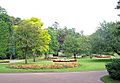
Open Spaces: Parks and Nature
Glossop has two public parks that have won the Green Flag Award: Manor Park and Howard Park. Manor Park offers great views of the countryside. Howard Park is known for its beautiful Victorian design. Glossop also has a weekly "parkrun" event in Manor Park every Saturday. Harehills Park, with its riverside path, was given to the town as a memorial after World War I.
-
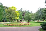
Manor Park's rose garden
-
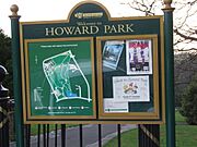
Notice board at the North Road entrance to Howard Park
-
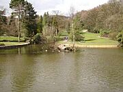
Howard Park duck pond in winter
-
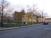
Norfolk Square, across from the Town Hall


Transport: Getting Around Glossop
.jpg)

Long ago, Glossop had horse-drawn buses and even an electric tramway from 1903 to 1927. Today, public transport is managed by Derbyshire County Council.
Railway
Glossop railway station is on the Glossop line. Trains run regularly between Manchester Piccadilly and Hadfield. A group called the "Friends of Glossop Station" works to make the station nicer and encourage more people to use the train.
Buses
Regular bus services connect Glossop to nearby towns like Buxton, New Mills, and Sheffield. The main bus companies are High Peak and Stagecoach Manchester.
Roads
The main road through Glossop is the A57 road. To the west, it leads to Manchester. To the east, it goes over the famous Snake Pass to Sheffield and the Hope Valley. Other roads connect Glossop to places like Barnsley, Chapel-en-le-Frith, and Buxton.
Leisure: Things to Do in Glossop
The Peak District Boundary Walk passes through Charlestown and Old Glossop, and the Pennine Bridleway goes near Gamesley and Hadfield. These are great for walking and cycling.
Schools and Learning
Glossop has many primary schools, including All Saints' RC Primary School and Simmondley Primary School. For older students, there are two secondary schools: St Philip Howard Catholic Voluntary Academy and Glossopdale School. Glossopdale also has a Sixth Form for further education.
The town has several libraries, including Glossop Library in Victoria Hall and Hadfield Library.
Sport: Glossop's Sporting Spirit
Glossop is special because it's the smallest town in England to have had a football team in the top league! Glossop North End played in the Football League between 1898 and 1915, even reaching Division One. The team still plays today in a lower league.
Glossop also has many other sports clubs, including tennis, golf, rugby, cricket, bowls, running, cycling, and sailing at Torside reservoir.
Culture: Arts and Events
Performing Arts
The Partington Theatre is a local amateur theatre with 120 seats. It puts on several plays each season. Glossop Improv is a group for adults who enjoy improvisation. Glossop & District Choral Society is a community choir, and Glossop Operatic and Dramatic Society performs musicals and plays.
Community Events
Glossop used to have a big "Victorian Weekend" event, which was even shown on the BBC. It had costume competitions and other fun activities. While that event has stopped, Glossop still has other cultural activities like the Peak Film Society and Glossop Folk Club.
Glossop has a lively indoor and outdoor market where you can buy many different goods. The indoor market is open on Thursdays, Fridays, and Saturdays. The outdoor market is open on Fridays and Saturdays, with a special Local Produce Market on the second Saturday of every month.
The Crown Inn pub on Victoria Street is a historic building, known for its traditional interior.
Emergency Services
Glossop has emergency services to keep everyone safe. Calls for help in the rural areas often increase in summer because many tourists visit the Peak District. Winter weather can also cause problems on the high ground.
Hospitals
For serious emergencies, people from Glossop usually go to Tameside General Hospital in Ashton-under-Lyne. This is because there isn't a large hospital with an Accident and Emergency Department directly in Glossop.
Ambulance and Paramedics
The North West Ambulance Service (NWAS) provides ambulance services in Glossop. They have an ambulance station on Chapel Street. Sometimes, the East Midlands Ambulance Service also helps out.
Fire Service
The Derbyshire Fire and Rescue Service provides fire and rescue cover. Glossop's fire station is in the Charlestown area.
Mountain Rescue
For special search and rescue in the mountains and moorlands, Glossop has a volunteer team called the Glossop Mountain Rescue Team. They are part of the Peak District Mountain Rescue Organisation and help save lives.
Twin Town: Friends Across the Sea
Glossop is twinned with Bad Vilbel, a spa town in Germany. It's about 5 miles (8 km) north-east of Frankfurt.
The Glossop–Bad Vilbel Twinning Association was started in 1985. Its goal is to build friendship and understanding between the people of Glossop and Bad Vilbel. They encourage visits, especially by children and young people, to learn about each other's cultures. In 1987, special ceremonies were held in both towns to make the twinning official, and a tree was planted in Norfolk Square.
Literature and Media: Glossop in Stories
Hilaire Belloc, a writer, once wrote about Glossop in a letter in 1909, describing it as a "filthy village" with "savages" and bad inns! However, this was just his humorous (and perhaps exaggerated) opinion.
Glossop is also mentioned in the satirical book England, Their England by A. G. Macdonell. The town's fictional newspaper, the Glossop Evening Mail, is described as a very small newspaper.
In 2013, Old Glossop was used for filming the BBC drama series The Village, starring John Simm and Maxine Peake. The Parish Church of All Saints and the old Duke of Norfolk school building appeared in the show.
Local newspapers include the Glossop Advertiser and the Glossop Chronicle. For TV news, people in Glossop watch BBC North West and ITV Granada. The town also has local radio stations like Glossop Community Radio and Greatest Hits Radio Derbyshire (High Peak).
Notable People from Glossop
Many interesting people have connections to Glossop:
- Andy Cannon (born 1996) – a professional footballer for Wrexham A.F.C., who lived in Simmondley.
- Eileen Cooper (born 1953) – a famous English painter and printmaker.
- Nicholas Garlick (c. 1555 – 1588) – an English priest.
- Matthew Ellison Hadfield (1812–1885) – a well-known architect, born in Lees Hall.
- Jeremy Heywood, Baron Heywood of Whitehall (1961–2018) – a very important government official who served as Cabinet Secretary to Prime Ministers David Cameron and Theresa May.
- John Vernon Lord (born 1939) – an illustrator and author of children's books, like The Giant Jam Sandwich.
- Hilary Mantel (1952–2022) – a famous British novelist and short story writer.
- Dan Money (born 1976) – a British bobsleigher who competed in the 2010 Winter Olympics.
- Alisha Palmowski (born 2006) – an English racing driver.
- Andy Wilman (born 1962) – the co-creator and producer of the BBC show Top Gear, born in Glossop.
- Ludwig Wittgenstein (1889–1951) – a famous Austrian philosopher, who stayed in Glossop in 1908 while studying at Manchester University.
Images for kids
-
Manor Park's rose garden
-

Notice board at the North Road entrance to Howard Park
-

Howard Park duck pond in winter
-
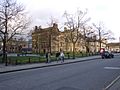
Norfolk Square, opposite the Town Hall
See also
 In Spanish: Glossop para niños
