Dark Peak facts for kids

The Dark Peak is a wild and high part of the Peak District in England. It mostly forms the northern section of the Peak District. However, it also stretches south along its eastern and western edges.
You can find the Dark Peak mainly in Derbyshire. But parts of it also reach into Staffordshire, Cheshire, Greater Manchester, West Yorkshire, and South Yorkshire.
Contents
Why is it called the Dark Peak?
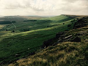
The Dark Peak gets its name from the type of rock found there. Unlike the White Peak, which has light-colored limestone, the Dark Peak is covered by a rock called Millstone Grit. This is a type of sandstone.
Underneath the gritstone, there is softer rock called shale. This means that in winter, the ground is almost always wet. The landscape is mostly wild moorland and high flat areas called plateaus. Many dips in the land are filled with sphagnum bogs and black peat. This dark, wet landscape gives the area its name.
Sometimes, people also call it the High Peak. However, High Peak is also the name of a local government area in Derbyshire. That area includes parts of both the Dark Peak and the White Peak.
Where is the Dark Peak?
The Millstone Grit rock forms a shape like an 'inverted horseshoe'. This shape surrounds the lower limestone areas of the White Peak. It wraps around the White Peak to the west, north, and east.
So, the Dark Peak covers several areas. These include the high northern moors between the Hope Valley and South Pennines. It also includes the Western Moors, which stretch south towards the Churnet Valley. And it covers the Eastern Moors, going south towards Matlock.
Natural England has defined 159 special areas in England. The Dark Peak is one of these "National Character Areas." This specific area covers about 86,604 hectares (334 square miles). It includes the northern hills near Marsden, Stocksbridge, Hathersage, and Chapel-en-le-Frith. It also has the eastern moors between Hathersage and Matlock.
Important Natural Areas
A large part of the Dark Peak is a special protected area. About 31,852 hectares (123 square miles) is called the Dark Peak Site of Special Scientific Interest (SSSI). This means it's a very important place for wildlife and nature. The Eastern Moors are also protected but are a separate SSSI.
The SSSI stretches across the borders into Greater Manchester and West Yorkshire. A big part of this SSSI is also included in the South Pennine Moors Special Area of Conservation. This is another important protection for its natural habitats.
Famous Hills and Edges
The Dark Peak is home to many well-known hills and rocky edges. Some of the main high areas include:
- Kinder Scout
- Bleaklow (both of these are over 600 meters or 1,968 feet high)
- Black Hill
- the Roaches
- Shining Tor
- Mam Tor
- Win Hill
- Stanage Edge
Aircraft Crashes
Over the years, some military aircraft have crashed in the Dark Peak. This often happened because there were many air bases nearby. Also, pilots might have been new, or their equipment was old or faulty. Bad weather and poor visibility also played a part.
Because the high moorlands are wild and empty, it was hard to remove all the wreckage. So, you can still find parts of planes at some remote crash sites. Sensitive military items were taken away. Sometimes, teams gathered debris into piles, or they burned or buried it.
See also
 In Spanish: Dark Peak para niños
 | Jessica Watkins |
 | Robert Henry Lawrence Jr. |
 | Mae Jemison |
 | Sian Proctor |
 | Guion Bluford |


