Black Hill (Peak District) facts for kids
Quick facts for kids Black Hill |
|
|---|---|

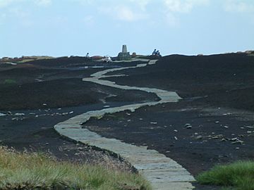
The Pennine Way on the summit of Black Hill
|
|
| Highest point | |
| Elevation | 582 m (1,909 ft) |
| Prominence | 165 m (541 ft) |
| Parent peak | Kinder Scout |
| Listing | Marilyn, County Top, Dewey |
| Geography | |
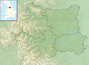
| Location | Derbyshire/West Yorkshire (historic Cheshire), England |
| Parent range | Peak District, |
| OS grid | SE078046 |
| Topo map | OS Landranger 110 |
Black Hill is a famous hill located in the Peak District area of England. It stands 582 meters (about 1,909 feet) above sea level.
This hill is special because it is the highest point in what used to be the county of Cheshire. It was part of a long, narrow piece of land known as the Cheshire Panhandle. This land stretched north of the Longdendale valley, which now has several reservoirs.
In 1974, new laws changed how local areas were managed in England. After these changes, Black Hill became a border point. It now sits between the areas of Kirklees in West Yorkshire and High Peak in Derbyshire.
Black Hill is one of the tallest hills in the Peak District. Only two other major peaks, Kinder Scout and Bleaklow, are higher. Like many hills in the Pennines, Black Hill has a very flat top, but its sides are quite steep.
The top of Black Hill is made of peat, which is a type of soil formed from decayed plants. This makes the ground very wet and boggy, especially after it rains. In the past, the area around the summit had very little plant life and looked quite dark. This is how the hill got its name. However, people have been working to restore the area. They have helped new plants grow and covered much of the exposed peat.
The Pennine Way, a long-distance walking path, crosses Black Hill. This path is now paved in many places. This means walkers can reach the top without getting their feet wet, even when the ground is very muddy.
Exploring Black Hill
You can reach Black Hill using several walking paths.
Pennine Way Routes
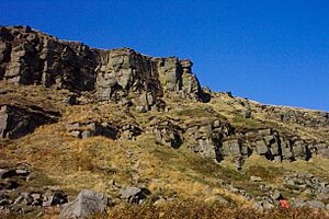
One popular way to visit the hill is by following the Pennine Way from Crowden. This route takes you past the impressive Laddow Rocks cliffs. If the ground isn't too wet, you can make a circular walk by returning over Westend Moss. This was actually the original route of the Pennine Way before 1966.
Another common starting point is from a place known as the 'Isle of Skye'. This spot is where the A635 meets the Wessenden Head Road, which leads to Meltham. From here, you can join a paved section of the Pennine Way that goes south towards Black Hill.
Other Approaches
You can also get to Black Hill from Holme Moss. This route crosses open access land. However, this path can be tricky. The ground is mostly flat, but there aren't always clear tracks. You might need a map and a compass to find your way.
After Black Hill, the Pennine Way continues south to Bleaklow and Kinder Scout. These two hills are slightly taller than Black Hill, both rising to just over 600 meters (2,000 feet).
Soldiers' Lump
The very highest point on Black Hill is marked by a special stone pillar. This pillar is called a triangulation column, or "trig point." It is located on a small raised area known as Soldiers' Lump. This spot is also the highest point in West Yorkshire.
Long ago, in 1784, the Royal Engineers started the first official survey of Britain. They used a special tool called a theodolite to measure the land. According to a famous walker named Alfred Wainwright, the wooden supports for this old measuring tool could still be found at Soldiers' Lump many years later.
 | Precious Adams |
 | Lauren Anderson |
 | Janet Collins |


