
Bleaklow facts for kids
Quick facts for kids Bleaklow Head |
|
|---|---|

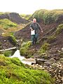
The boggy "summit" of Bleaklow
|
|
| Highest point | |
| Elevation | 633 m (2,077 ft) |
| Prominence | 128 m |
| Parent peak | Kinder Scout |
| Listing | Hewitt, Nuttall, HuMP |
| Geography | |
| Location | Derbyshire, England, UK |
| Parent range | Peak District |
| OS grid | SK094960 |
| Topo map | OS Landranger 110 |
| Listed summits of Bleaklow | ||||
| Name | Grid ref | Height | Status | |
|---|---|---|---|---|
| Higher Shelf Stones | SK089948 | 621 m | Nuttall | |
| Bleaklow Stones | SK116964 | 628 m | ||
Bleaklow is a large, high area of land in the Peak District of Derbyshire, England. It is mostly covered in peat and gritstone rocks. This moorland is located north of Kinder Scout, near the town of Glossop.
Much of Bleaklow is very high, almost 610 meters (2,000 feet) above sea level. The River Derwent starts from a shallow area called Swains Greave on its eastern side.
Bleaklow Head is the highest point on the western side of this moor. It is 633 meters (2,077 feet) tall and is marked by a large pile of stones called a cairn. The long-distance walking path, the Pennine Way, crosses Bleaklow Head.
Bleaklow has three main peaks that are over 610 meters (2,000 feet) high. Besides Bleaklow Head, there are Bleaklow Stones (about 3 kilometers or 1.9 miles to the east) and Higher Shelf Stones (about 1.5 kilometers or 0.9 miles south of Bleaklow Head). Bleaklow is the second-highest point in Derbyshire.
Contents
Exploring Bleaklow's Landscape
The main part of Bleaklow is a wet, boggy area covered in peat. It has many 'groughs', which are channels cut into the peat by water. These channels make the land look like it has seams.
Because there are not many big changes in height, walking across Bleaklow can be tricky. It is known as one of the most challenging places to navigate in the Peak District when the weather is bad.
Protecting Bleaklow's Environment
Bleaklow is part of the National Trust's High Peak Estate. A lot of effort has been put into protecting and restoring this special area.
Workers have been blocking many of the eroded peat channels. This helps to keep the peat wet and allows healthy Sphagnum moss to grow again. This moss is very important for forming new peat. It also helps to capture carbon from the air and clean the water supply.
Much of this work was organized by the Moors for the Future Partnership. They used funding from the EU LIFE+ programme between 2010 and 2015. They laid 52 kilometers (32 miles) of special fabric to stabilize the peat. They also built 4,000 small dams to hold water. Over 150,000 moorland plants were planted, and 807 million Sphagnum moss pieces were spread across the area.
Amazing Views from Bleaklow
From the top of Bleaklow, you can see far and wide. To the west, you can see cities like Manchester, and parts of Lancashire and Cheshire.
Looking east, you can see towards the Hope Valley, Holme Moss, and Yorkshire. On very clear days, it is even possible to see Snowdonia in North Wales.
Remembering the Bleaklow Bomber

Bleaklow is also the site of several aircraft crashes. One well-known event happened on November 3, 1948. A USAF RB-29A Superfortress plane crashed at Higher Shelf Stones.
The plane was flying from Scampton to Burtonwood. Sadly, all 13 crew members on board died in the crash. Today, a lot of the plane's wreckage, known as the Bleaklow Bomber, can still be seen. It serves as a memorial to the crash. A proper memorial was also put up at the site in 1988. People can visit this area to remember those who were lost.
Images for kids
-
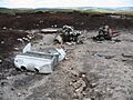
Engine wreckage on Shelfstones
-
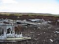
General view of the aircraft wreckage
-
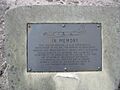
Memorial plaque by the wreckage
-
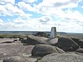
Trig point on Shelf Stones
-
Descending eroded peat gully on east flank of Bleaklow


