
Win Hill facts for kids
Quick facts for kids Win Hill |
|
|---|---|
 |
|
| Highest point | |
| Elevation | 463 m (1,519 ft) |
| Prominence | c. 144 m (472 ft) |
| Geography | |
| Location | Peak District, England |
| OS grid | SK186850 |
| Topo map | OS Landranger 110 |
Win Hill is a famous hill located in the Peak District of England. It stands proudly north-west of the village of Bamford in Derbyshire. The top of Win Hill is about 462 meters (1,516 feet) above the sea.
This hill is surrounded by rivers and a large reservoir. To the east, you'll find the River Derwent. The River Noe is to the south-west. To the north, there's the beautiful Ladybower Reservoir. A ridge connects Win Hill to Kinder Scout in the north-west. An old Roman road from Glossop crosses this ridge. It then goes down to Hope and the ancient Roman base of Brough. You can still see the Hope Cross, a special marker post from 1737, at the highest point of this old road.
Contents
What is Win Hill Pike?
Right at the very top of Win Hill, there's a smaller peak called Win Hill Pike. People in the area often call it "the Pimple" because of its shape. On Win Hill Pike, you'll find a special marker. It's an Ordnance Survey triangulation point, also known as a trig point. These points are used by mapmakers to create accurate maps of the land.
Sometimes, people mistakenly call Win Hill Pike the "Old Witches Knoll." It's also a popular spot for young people taking part in the Duke of Edinburgh Award. This award helps young people develop new skills and go on adventures.
How to Climb Win Hill
Many people enjoy climbing Win Hill. One popular way to start is from a place called Yorkshire Bridge. This path is quite steep! You'll climb about 300 meters (984 feet) in just three-quarters of a mile. The path goes through woods first, then opens up onto the moorland before reaching the top.
You can also start your climb from the village of Hope. These routes are usually a bit easier. You can go through Twitchill Farm or the villages of Aston and Thornhill. Win Hill is part of some challenging long-distance walks. It's either the first or last hill on the "Derwent Watershed" and "Edale Horseshoe" routes.
Win Hill and Lose Hill
Win Hill has a partner hill nearby called Lose Hill. It's located to the west, across the River Noe. The names of these two hills, Win (meaning "win" a battle) and Lose (meaning "lose" a battle), have led to a fun story.
The Fanciful Battle Story
Long ago, people made up a tale about a battle fought here in the 7th century. The story says that King Edwin of Northumbria and King Cynegils of Wessex had a fight. King Edwin's soldiers were on Win Hill, and King Cynegils' men were on Lose Hill.
As the battle went on, Cynegils' soldiers tried to climb Win Hill. Edwin's men supposedly built a temporary wall near the top. They then pushed large rocks from this wall down the hill. These rocks crushed the Wessex soldiers, giving Edwin's side the victory!
However, this is just a story. There's no real proof that this battle ever happened here. It's a fun legend, but not a true historical event.
The Real Meaning of the Name
A more likely reason for the name "Win Hill" is much simpler. The hill was originally called Wythinehull. This old name means "Withy Hill" or "Willow Hill." You can still find small pieces of willow trees in the mostly pine forest on the way up from Yorkshire Bridge. This suggests the name comes from the types of trees that grew there long ago.
Images for kids
-
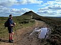
The approach to Win Hill Pike

