Harridge Pike facts for kids
Quick facts for kids Harridge Pike |
|
|---|---|

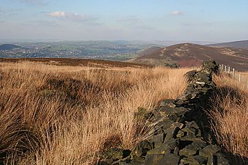
Harridge Pike from the south
|
|
| Highest point | |
| Elevation | 395 m (1,296 ft) |
| Prominence | c. 40 m |
| Listing | (none) |
| Geography | |
| Location | Greater Manchester, England |
| Parent range | Peak District, Pennines |
| OS grid | SJ994999 |
| Topo map | OS Landranger 109 |
Harridge Pike is a hill located in Stalybridge, Greater Manchester, England. It sits right next to the amazing Peak District National Park. This hill reaches a height of 395 meters (about 1,296 feet) above sea level. It's a popular spot for people who love to explore the outdoors and enjoy great views.
Where is Harridge Pike Located?
Harridge Pike is on the western side of the River Tame valley. From there, the land rises up to the hill's peak. To the east, the hill gently slopes down towards Swineshaw Moor. This moorland eventually leads to Irontongue Hill, which is part of Hoarstone Edge.
What Can You See From the Top?
When you reach the top of Harridge Pike, you get some incredible views! You can see a large part of the Tame valley and the entire town of Stalybridge. On a clear day, you can even spot big parts of eastern Manchester and the city centre. You might even see the Manchester Town Hall. If the weather is super clear, you might even catch a glimpse of the mountains of Snowdonia in Wales!
Exploring Harridge Pike and the Area
Since 2004, the moorland around Harridge Pike has been known as "access land." This means that people are allowed to walk and explore freely across these areas. It's a fantastic place for hiking and enjoying nature. The paths are great for walking, and it's a good way to get some exercise while seeing beautiful scenery.
 | James B. Knighten |
 | Azellia White |
 | Willa Brown |

