
Mamucium facts for kids
Quick facts for kids Mamucium |
|
|---|---|
.jpg) |
|
| General information | |
| Architectural style | Roman fort |
| Location | Manchester, England |
| Coordinates | 53°28′33″N 2°15′03″W / 53.475962°N 2.250891°W |
| Completed | 79 |
Mamucium, also known as Mancunium, was an ancient Roman fort located in the Castlefield area of Manchester, England. It was built around 79 AD in the Roman province of Britannia. The fort was home to a group of Roman Auxiliaries, who were soldiers from other parts of the Roman Empire. It was strategically placed near two important Roman roads.
Outside the fort, several large civilian settlements, called vicus, grew up. These settlements were where soldiers' families, merchants, and workers lived. Today, the area is a protected ancient monument.
The fort's ruins remained untouched for many centuries. However, during the Industrial Revolution in the late 1700s, Manchester grew very quickly. Much of the fort was flattened to make way for new buildings and projects, like the Rochdale Canal and the Great Northern Railway. Now, the site is part of the Castlefield Urban Heritage Park. Visitors can see a reconstructed section of the fort's wall, its gatehouse, and other buildings from the vicus.
Contents
What's in a Name?
The name Mamucium likely comes from an old Celtic word. It might mean "breast," referring to a "breast-like hill." Or, it could mean "mother," possibly linked to a local river goddess.
Both meanings are still found in modern Celtic languages. For example, mam means "breast" in Irish and "mother" in Welsh. The Welsh name for Manchester, Manceinion, probably comes from this ancient Celtic word too.
Where Was the Fort Built?
The Romans chose a great spot for their fort. It was on a natural sandstone bluff that looked over a crossing point on the River Medlock. This area became a key meeting point for at least two major military roads.
One road ran east to west, connecting the large Roman fortresses of Deva Victrix (Chester) and Eboracum (York). Another road went north to Bremetennacum (Ribchester). Mamucium might also have overseen a smaller road heading northwest to Coccium (Wigan).
Mamucium was part of a chain of forts along the Eboracum to Deva Victrix road. Castleshaw Roman fort was about 16 miles (26 km) to the east. Condate (Northwich) was about 18 miles (29 km) to the west.
The Fort's History

Before the Romans Arrived
There's no proof that people lived exactly where the fort was before the Romans. However, signs of Stone Age activity have been found nearby. These include Mesolithic flints and a Neolithic scraper. A piece of late Bronze Age pottery was also discovered.
The area was part of the land of the Celtic tribe called the Brigantes. When the Romans arrived, a smaller group of the Brigantes, called the Setantii, might have been in control.
Roman Times
Building Mamucium started around 79 AD. This was during the campaigns of General Julius Agricola against the Brigantes, after a peace agreement failed. Digs show the fort was built in three main stages. The first was in 79 AD, the second around 160 AD, and the third in 200 AD.
The first fort was made of turf and timber. It was designed for a cohort, which was about 500 foot soldiers. These soldiers were not Roman citizens but foreign auxiliaries who joined the Roman army.
By the late 1st and early 2nd centuries, a civilian settlement (the vicus) grew around the fort. Around 90 AD, the fort's ramparts were made stronger. Mamucium was taken down around 140 AD. The first vicus grew fast but was abandoned between 120 and 160 AD, around the same time the fort was demolished. It was re-inhabited when the fort was rebuilt.

The second fort was built around 160 AD. It was also made of turf and timber, but it was larger. It covered about 2 hectares (4.9 acres) and had more granaries (storage buildings for grain). Around 200 AD, the fort's gatehouses were rebuilt with stone. The walls around the fort were also given a stone outer layer.
A part of the vicus had many furnaces in sheds. This area has been called an "industrial estate," which would have been Manchester's first! Mamucium was listed in the Antonine Itinerary, a 3rd-century list of roads in the Roman Empire. This, along with repairs to buildings, shows Mamucium was still in use in the early 3rd century.
The vicus might have been abandoned by the mid-3rd century. This is supported by findings of demolished buildings whose materials were taken for use elsewhere. Coins suggest that while the civilian settlement declined, a small group of soldiers might have stayed at Mamucium into the late 3rd and early 4th centuries.
A temple to Mithras might have been linked to the civilian settlement in modern Hulme. An altar dedicated to "Fortune the Preserver" was found, likely from the early 3rd century. In 2008, an altar from the late 1st century was found near the Roman settlement. It was dedicated to two minor Germanic gods and was in "fantastic" condition.
The County Archaeologist said:
"It's the first Roman stone inscription to be found in Manchester for 150 years and records only the second known Roman from Manchester ... The preservation of the stone is remarkable. On top of the stone is a shallow bowl which was used for offerings of wine or blood or perhaps to burn incense."
—Norman Redhead
Besides Pagan worship, there's also evidence of early Christian worship. In the 1970s, a piece of a 2nd-century "word square" was found. This square is an anagram of PATER NOSTER. Experts have discussed whether this "word square," carved on a piece of amphora, is truly a Christian artifact. If so, it would be one of the earliest signs of Christianity in Britain.
After the Romans Left

After the Roman withdrawal from Britain around 410 AD, the Mamucium area was used for farming. Some people think it might be the Cair Maunguid mentioned in an old book called History of the Britons. This book lists 28 cities in Britain.
Mamucium in Later Centuries
For centuries, the ruins lay forgotten. Then, in the 16th to 18th centuries, historians and people interested in old things started to notice them. John Leland in the 16th century, William Camden in the late 16th and early 17th centuries, and William Stukeley and John Whitaker in the 18th century all wrote about the site.
In the early 1700s, John Horsley said:
It [i.e., the fort] is about a quarter of a mile out of the town, being south or south-west from it. The station now goes by the name of Giant's Castle or Tarquin's Castle, and the field in which it stands is called Castle Field ... the ramparts are still very conspicuous.
—John Horsley, Britannia Romana
The Industrial Revolution's Impact
Mamucium was leveled as Manchester grew during the Industrial Revolution. The building of the Rochdale Canal in the late 1700s and early 1800s, and railway viaducts in the late 1800s, damaged and even destroyed parts of the fort. When the railway viaducts were built, Charles Roeder recorded the remains that were found.
Castlefield became the southwest corner of Manchester city centre. Deansgate, a main road today, generally follows the path of the old Roman road to Ribchester.
Discoveries in the 20th Century
The first archaeological dig at Mamucium was in 1906. Francis Bruton explored the fort's western defenses. More small digs happened between 1912 and 1967, mostly looking at the fort's northern defenses. In the mid-1900s, historian A. J. P. Taylor called the remaining Roman wall "the least interesting Roman remains in Britain."
The first dig of the vicus happened in the 1970s under Professor Barri Jones. In 1982, the fort and the Castlefield area became the UK's first Urban Heritage Park. Parts of the fort's walls, including ramparts and gateways, were rebuilt and opened in 1984.
From 2001 to 2005, the University of Manchester Archaeological Unit dug in the vicus. They wanted to learn more about the site before more building happened. So far, about 10,000 artifacts have been found from the Mamucium Roman fort and its civilian settlement.
How the Fort Was Designed
The fort was about 160 meters (175 yards) long and 130 meters (142 yards) wide. It was surrounded by two ditches and a wooden rampart (a defensive bank). Around 200 AD, the wooden rampart was replaced with stone walls. These walls were between 2.1 meters (7 feet) and 2.7 meters (9 feet) thick.
The vicus, or civilian settlement, surrounded the fort on the west, north, and east sides. Most of it was to the north. The vicus covered about 26 hectares (64 acres), while the fort itself was about 2 hectares (4.9 acres). Buildings in the vicus were usually one story high, made with timber frames, and used wattle and daub (a mix of woven branches and mud) for walls. There might have been a cemetery southeast of the fort.
For comparison, Templeborough Roman Fort in Yorkshire was rebuilt in stone in the 2nd century and covered about 5.5 acres (2.2 ha), which is similar in size to Mamucium.
Images for kids
-
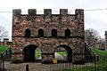
Reconstructed gateway to Roman fort (Mamucium), Castlefield

