Antonine Itinerary facts for kids
The Antonine Itinerary (which means "The Itinerary of the Emperor Antoninus" in Latin) was like an ancient Roman "road map" or travel guide. It listed important stops and distances along the many roads of the Roman Empire. It's a very valuable historical record because not many other documents like it still exist today.
This important document was probably created in the early 200s AD. Even though its name suggests it was made under Antoninus Pius, an emperor from the 100s AD, the oldest copies we have are from a later time.
Contents
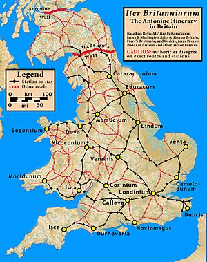
Iter Britanniarum
The British part of the Itinerary is called the Iter Britanniarum. Think of it as the 'road map' for Roman Britain. There are 15 different routes listed for Britain in this document.
The Itinerary measures distances in Roman miles. One Roman mile was equal to 1,000 Roman paces. A Roman pace was two steps (left foot then right foot). This meant a Roman mile was about 1,480 meters, or almost a modern mile.
Examples of British Routes
Here are some examples of routes from the Iter Britanniarum. They show the old Latin names for places and what we think those places are called today. They also show the distances in Roman miles.
Route 13
This table shows parts of Route 13, which went from Isca Silurum to Calleva Atrebatum.
| Latin name | Modern name (possible) | Distance | ||
|---|---|---|---|---|
| Roman miles | Kilometers | English miles | ||
| Item ab Isca Calleva mpm cviiii sic | A route from Isca Silurum to Calleva Atrebatum | 109 | 161 | 100 |
| Burrio mpm viii | Usk, Monmouthshire | 8 | 12 | 7.5 |
| Blestio mpm xi | Monmouth, Monmouthshire | 11 | 16 | 10 |
| Ariconio mpm xi | Bury Hill, Weston under Penyard, Herefordshire | 11 | 16 | 10 |
| Clevo mpm xv | Gloucester, Gloucestershire | 15 | 22 | 14 |
| (no entry - mpm xx) | perhaps Corinium Dobunnorum at modern Cirencester, Gloucestershire | (20) | (30) | (18.5) |
| Durocornovio mpm xiiii | perhaps Wanborough, Wiltshire | 14 | 21 | 13 |
| Spinis mpm xv | Speen, Berkshire | 15 | 22 | 14 |
| Calleva mpm xv | Silchester, Hampshire | 15 | 22 | 14 |
Route 14
This table shows parts of Route 14, another way to get from Isca Silurum to Calleva Atrebatum.
| Latin name | Modern name (possible) | Distance | ||
|---|---|---|---|---|
| Roman miles | Kilometers | English miles | ||
| Item alio itinere ab Isca Calleva mpm ciii sic | An alternate route from Isca Silurum to Calleva Atrebatum | 103 | 152 | 95 |
| Venta Silurum mpm viiii | Caerwent, Monmouthshire | 9 | 13 | 8 |
| Abone mpm xiiii | Sea Mills, Gloucestershire | 14 | 21 | 13 |
| Traiectus mpm viiii | perhaps Bitton, near Willsbridge, Gloucestershire | 9 | 13 | 8 |
| Aquis Solis mpm vi | Bath, Somerset | 6 | 9 | 5.5 |
| Verlucione mpm xv | Sandy Lane, Wiltshire | 15 | 22 | 14 |
| Cunetione mpm xx | Mildenhall, Wiltshire | 20 | 30 | 18.5 |
| Spinis mpm xv | Speen, Berkshire | 15 | 22 | 14 |
| Calleva mpm xv | Silchester, Hampshire | 15 | 22 | 14 |
Tricky Old Documents
Sometimes, old documents can be tricky. There was a fake document called De Situ Britanniae that caused confusion about Roman roads in Britain for a long time. It was made in the 1700s but pretended to be ancient. People believed it was real until the mid-1800s. This meant that even maps made by experts sometimes had wrong information because of this fake document.
Even after people found out it was a fake, some old books and maps still had its false information. So, when studying ancient history, it's important to check your sources carefully!
Some historians have also thought about why some distances in the Antonine Itinerary seem a bit off. One idea was that some Latin words were missing. Another idea is that the distances were measured from the edges of towns, not from their very centers. This could explain why the numbers sometimes look a little different than expected.
Hispania
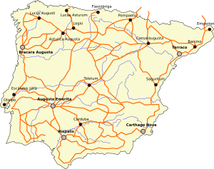
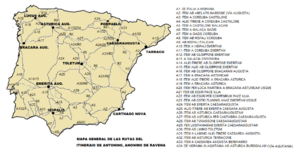
The Antonine Itinerary also lists 34 routes for the Roman provinces in Hispania (modern-day Spain and Portugal). This shows how vast the Roman road network was across their empire.
| Route | Start | End | Distance (Roman miles) |
|---|---|---|---|
| 1 | Mediolanum (Milan) | Legio VII Gemina (León) | 1257 |
| 2 | Arelate (Arles) | Castulo | 898 |
| 3 | Corduba (Córdoba) | Castulo | 99 |
| 4 | Corduba | Castulo | 78 |
| 5 | Castulo | Malaca (Málaga) | 291 |
| 6 | Malaca | Gades (Cádiz) | 145 |
| 7 | Gades | Corduba | 294 |
| 8 | Hispalis (Seville) | Corduba | 94 |
| 9 | Hispalis | Italica | 6 |
| 10 | Hispalis | Emerita (Mérida) | 162 |
| 11 | Corduba | Emerita | 144 |
| 12 | Olisipo (Lisbon) | Emerita | 161 |
| 13 | Salacia (Alcácer) | Ossonoba (Faro) | 16 |
| 14 | Olisipo | Emerita | 145 |
| 15 | Olisipo | Emerita | 220 |
| 16 | Olisipo | Bracara (Braga) | 244 |
| 17 | Bracara | Asturica (Astorga) | 247 |
| 18 | Bracara | Asturica | 215 |
| 19 | Bracara | Asturica | 299 |
| 20 | Bracara | Asturica | 207 |
| 21 | Esuris (Castro Marim) | Pax Julia | 267 |
| 22 | Esuris | Pax Julia | 76 |
| 23 | Mouth of the Ana (Guadiana) | Emerita | 313 |
| 24 | Emerita | Caesaraugusta (Zaragoza) | 632 |
| 25 | Emerita | Caesaraugusta | 348 |
| 26 | Asturica | Caesaraugusta | 497 |
| 27 | Asturica | Caesaraugusta | 301 |
| 28 | Turiaso (Tarazona) | Caesaraugusta | 56 |
| 29 | Emerita | Caesaraugusta | 458 |
| 30 | Laminium (Fuenllana) | Toletum (Toledo) | 95 |
| 31 | Laminium | Toletum | 249 |
| 32 | Asturica | Tarraco (Tarragona) | 482 |
| 33 | Caesaraugusta | Benearnum (Lescar) | 112 |
| 34 | Asturica | Burdigala (Bordeaux) | 421 |
See also
 In Spanish: Itinerario de Antonino para niños
- Roman units
 | Aurelia Browder |
 | Nannie Helen Burroughs |
 | Michelle Alexander |


