
Braga facts for kids
Quick facts for kids
Braga
|
|||
|---|---|---|---|
|
Municipality
|
|||
.jpg) _(cropped).jpg) .jpg) _(cropped).jpg) _(cropped).jpg)  .jpg) Top: Banco de Portugal; Sameiro Sanctuary; middle: Congregados Church; Bom Jesus do Monte; Tibães Monastery; bottom: Arco da Porta Nova; Braga Episcopal Palace.
|
|||
|
|||
 |
|||
| Country | |||
| Region | Norte | ||
| Intermunic. comm. | Cávado | ||
| District | Braga | ||
| Parishes | 37, see text | ||
| Area | |||
| • Total | 183.40 km2 (70.81 sq mi) | ||
| Elevation | 200 m (700 ft) | ||
| Highest elevation | 558 m (1,831 ft) | ||
| Population
(2023)
|
|||
| • Total | 201,583 | ||
| • Density | 1,099.14/km2 (2,846.77/sq mi) | ||
| Time zone | WET/WEST (UTC+0/+1) | ||
| Postal code |
47xx
|
||
| Area code | 253 | ||


Braga is a lively city and municipality in northwestern Portugal. It is the capital of the Braga district and the historical Minho Province. In 2023, Braga Municipality had over 200,000 people, making it the seventh largest municipality in Portugal. Its urban area is the third most populated in Portugal, after Lisbon and Porto.
Braga is home to Portugal's oldest archdiocese, which is a major religious center for the Catholic Church. During the time of the Roman Empire, it was known as Bracara Augusta. It served as the capital of the Roman province of Gallaecia. Later, it became the capital of the Kingdom of the Suebi, one of the first kingdoms to break away from the Roman Empire in the 5th century. Today, Braga is a hub for business and technology in Portugal. It is also an important stop on the Portuguese Way, a famous pilgrimage route. The city hosted two games during the UEFA Euro 2004 football tournament and was the European Youth Capital in 2012.
Contents
A Quick Look at Braga's Past
Braga has a very long and interesting history, going back thousands of years! People have lived here since the Megalithic era, building large stone structures.
How Braga Began: Before the Romans
Long ago, during the Iron Age, a group of Celts called the Bracari lived here. They built fortified villages on high ground for protection. This area became known as the land of the Callaici Bracarii.
Roman Braga: Bracara Augusta
The Romans arrived around 136 BC and fully conquered the region during the time of Emperor Augustus. The city of Bracara Augusta was founded in 16 BC. It grew quickly and became very important by the 2nd century.
By the late 3rd century, Emperor Diocletian made Bracara Augusta the capital of a large Roman area called Conventus bracarensis. This was part of the new Roman province of Gallaecia.
Braga in the Middle Ages

In the 4th century, a poet described Braga as a rich city. Between 402 and 470, Germanic tribes invaded the Iberian Peninsula. The Suebi, a Germanic people, conquered the area. In 410, they created a kingdom in northwest Iberia, making Braga their capital. This kingdom, called Gallaecia, lasted over 150 years.
Later, the Visigoths took control of Gallaecia from the Suebi around 584. Braga then became a provincial capital for them. Braga is home to the oldest chapel in Portugal, the Chapel of São Frutuoso. It was built by the Visigoths on top of an old Roman temple.
Braga played a big role in spreading Christianity in the Iberian Peninsula. In the 6th century, Saint Martin of Braga helped the Suebi people change from their old beliefs to Christianity. He also founded an important monastery nearby.
After the Muslim conquest, Braga went through a tough time. The Moors briefly captured it in 714–716. Christian forces eventually pushed them out for good in 868. The bishopric (the area managed by a bishop) was restored in 1070. The first new Archbishop, Peter of Braga, started rebuilding the Braga Cathedral.
Between 1093 and 1147, Braga became the home of the Portuguese court. In the early 12th century, Count Henry of Portugal and Archbishop Geraldo de Moissac made Braga a very powerful religious center. The medieval city grew around its cathedral, with the archbishop holding great power.
Braga in the Kingdom of Portugal
Braga was a major center for Christianity during the Reconquista (the Christian reconquest of Iberia). It helped Portugal become an independent kingdom. In 1179, the Pope recognized Portugal as an independent Kingdom thanks to the help of Archbishop D. Paio Mendes. Because of this support, the king gave Braga special rights, making it directly controlled by the Church. This special status lasted until the First Portuguese Republic was formed in 1910.
In the 16th century, Braga was modernized by Archbishop Diogo de Sousa. He improved streets, created public squares, and built hospitals and churches. He also expanded the cathedral, turning the medieval town into a Renaissance city.
The 18th century brought another period of growth. Archbishops from the House of Braganza hired famous architects like André Soares and Carlos Amarante. They transformed many churches and public buildings into the beautiful Baroque style. This included the city hall and the famous Sanctuary of Bom Jesus do Monte.
In 1809, French troops took Braga during the Peninsular Wars. After this, Braga became a less important provincial city again. However, by the late 1800s, money from Portuguese people living in Brazil helped improve the city's buildings and services.
Braga in the Republic
The old Castle of Braga in the city center was torn down in 1905, even though some people tried to save it. A museum was eventually created in Braga in 1918.
On May 28, 1926, General Gomes da Costa started a march from Braga to Lisbon. This led to the end of the First Portuguese Republic and the start of a new government. The dictator António de Oliveira Salazar visited Braga many times to celebrate this event.
In the 20th century, Braga continued to grow. More people moved from the countryside to the city, which meant that Braga's services and buildings had to be improved to meet the new demands.
Where is Braga?
Braga is in the heart of the Minho region. It sits between mountains, forests, valleys, and plains. To the north, it borders Vila Verde and Amares. To the east, it's next to Póvoa de Lanhoso. To the south, you'll find Guimarães and Vila Nova de Famalicão, and to the west, Barcelos.
The area has many valleys and mountains. The Cávado River forms its northern border. The highest points are the Serra dos Picos (566 meters) and Monte do Sameiro (572 meters). The city center itself is about 215 meters above sea level.
Braga's Weather
Braga has a warm-summer Mediterranean climate. This means it has clear seasons. Summers are quite hot, and winters are mild. The highest temperature ever recorded was 42.2°C (108°F), and the lowest was -7°C (19°F).
The Atlantic Ocean brings a lot of humidity, especially in the mornings. The average yearly temperature is around 15°C (59°F). It rains a lot, especially from autumn to spring, with about 1449 mm (57 inches) of rain each year. Frost can happen about nine days a year, usually between three and four months.
| Climate data for Braga, 1981–2010 normals, extremes 1941–present, altitude: 190 m (620 ft) | |||||||||||||
|---|---|---|---|---|---|---|---|---|---|---|---|---|---|
| Month | Jan | Feb | Mar | Apr | May | Jun | Jul | Aug | Sep | Oct | Nov | Dec | Year |
| Record high °C (°F) | 24.0 (75.2) |
23.5 (74.3) |
29.5 (85.1) |
31.0 (87.8) |
35.5 (95.9) |
38.5 (101.3) |
41.1 (106.0) |
42.2 (108.0) |
38.5 (101.3) |
33.3 (91.9) |
28.5 (83.3) |
24.1 (75.4) |
42.2 (108.0) |
| Mean daily maximum °C (°F) | 13.7 (56.7) |
14.8 (58.6) |
17.6 (63.7) |
18.3 (64.9) |
21.1 (70.0) |
25.4 (77.7) |
27.8 (82.0) |
28.0 (82.4) |
25.5 (77.9) |
20.9 (69.6) |
16.8 (62.2) |
14.4 (57.9) |
20.3 (68.5) |
| Daily mean °C (°F) | 9.0 (48.2) |
9.9 (49.8) |
12.3 (54.1) |
13.2 (55.8) |
15.8 (60.4) |
19.5 (67.1) |
21.4 (70.5) |
21.4 (70.5) |
19.4 (66.9) |
15.9 (60.6) |
12.3 (54.1) |
10.2 (50.4) |
15.0 (59.0) |
| Mean daily minimum °C (°F) | 4.3 (39.7) |
4.9 (40.8) |
7.0 (44.6) |
7.9 (46.2) |
10.4 (50.7) |
13.5 (56.3) |
14.9 (58.8) |
14.7 (58.5) |
13.2 (55.8) |
10.8 (51.4) |
7.7 (45.9) |
6.0 (42.8) |
9.6 (49.3) |
| Record low °C (°F) | −7.0 (19.4) |
−4.5 (23.9) |
−5.0 (23.0) |
−1.2 (29.8) |
−0.5 (31.1) |
3.3 (37.9) |
7.5 (45.5) |
6.7 (44.1) |
3.8 (38.8) |
2.5 (36.5) |
−1.7 (28.9) |
−2.5 (27.5) |
−7.0 (19.4) |
| Average precipitation mm (inches) | 176.4 (6.94) |
114.8 (4.52) |
121.6 (4.79) |
130.8 (5.15) |
112.9 (4.44) |
48.6 (1.91) |
22.0 (0.87) |
34.0 (1.34) |
81.7 (3.22) |
191.7 (7.55) |
193.9 (7.63) |
220.2 (8.67) |
1,448.6 (57.03) |
| Average precipitation days (≥ 0.1 mm) | 14.8 | 13.5 | 12.2 | 13.5 | 13.4 | 8.2 | 5.4 | 4.7 | 7.4 | 12.7 | 13.1 | 15.5 | 134.4 |
| Source: Instituto Português do Mar e da Atmosfera | |||||||||||||
Braga's Population
|
|||||||||||||||||||||||||||||||||||||||||||||||||
Braga is a very populated area, with about 962 people per square kilometer. In 2011, it had 181,474 residents. It's one of the most populated and "youngest" areas in Portugal. Most people live in the city of Braga itself, where there are over 10,000 people per square kilometer.
About 35% of Braga's population is under 25 years old, while only 11% are seniors. This means a large part of the population is of working age. While most people are Portuguese, there are also communities from Brazil, African countries, China, and Eastern Europe (especially Ukraine).
Many homes in Braga are temporary residences for students, workers, or people visiting from overseas. This means the number of people in Braga can change throughout the year, usually between 174,000 and 230,000.
Civil Parishes
The municipality of Braga is divided into 37 civil parishes, which are like local districts. Each parish has its own local council that helps manage the area.
- Adaúfe
- Arentim e Cunha
- Braga (Maximinos, Sé e Cividade)
- Braga (São José de São Lázaro e São João do Souto)
- Cabreiros e Passos (São Julião)
- Celeirós, Aveleda e Vimieiro
- Crespos e Pousada
- Escudeiros e Penso (Santo Estêvão e São Vicente)
- Espinho
- Esporões
- Este (São Pedro e São Mamede)
- Ferreiros e Gondizalves
- Figueiredo
- Gualtar
- Guisande e Oliveira (São Pedro)
- Lamas
- Lomar e Arcos
- Merelim (São Paio), Panoias e Parada de Tibães
- Merelim (São Pedro) e Frossos
- Mire de Tibães
- Morreira e Trandeiras
- Nogueira, Fraião e Lamaçães
- Nogueiró e Tenões
- Padim da Graça
- Palmeira
- Pedralva
- Priscos
- Real, Dume e Semelhe
- Ruilhe
- Santa Lucrécia de Algeriz e Navarra
- São Vicente
- São Victor
- Sequeira
- Sobreposta
- Tadim
- Tebosa
- Vilaça e Fradelos
Braga's Economy

Braga is a growing city with important industries. These include construction, metalwork, and making electrical and electronic equipment. Software development and web design are also very important here.
Many computer companies are based in Braga. For example, PRIMAVERA BSS, a Portuguese software company, has its main office here. The International Iberian Nanotechnology Laboratory (INL), a research center for tiny technology, is also in Braga.
The car industry has a long history in Braga. Companies like Aptiv and Robert Bosch GmbH have technical centers here. They develop things like car entertainment systems and sensors. Bosch works closely with the University of Minho, making it one of Portugal's biggest university-company partnerships.
The University of Minho, which has its main campus in Braga, is a big part of the city's economy.
Getting Around Braga
Braga has a small airfield for local flights. For international travel, most people use the Sá Carneiro International Airport (Porto Airport), which is about 50 km (31 miles) away. You can get there by public transport from Braga in about 40-50 minutes.
The city has good train connections to other major cities in Portugal and beyond. Braga also has an efficient bus network called TUB (Transportes Urbanos de Braga), with 76 lines covering over 300 km (186 miles).
Famous Buildings and Places
Braga is full of amazing historical buildings and structures from different time periods. Many of these are considered National Monuments.
Ancient Roman Sites
- Roman Thermae of Maximinus: These ancient Roman baths were discovered in the 20th century. They cover 800 square meters and were built between the 1st and 3rd centuries.
- Fountain of the Idol: This 1st-century Roman fountain is dedicated to an ancient local god.
Important Civic Buildings
- Arch of Porta Nova: This beautiful arch was designed in the late 18th century. It marks the western gate of the old medieval city wall. It's traditionally used to welcome important visitors.
- Palace of Raio: An 18th-century palace known for its detailed blue tile (azulejo) facade.
- Theatro Circo: A 20th-century theater famous for its architecture, where you can watch films, plays, and performances.
- Bridge of Prado and Bridge of Prozelo: Historic bridges in the area.
Military Structures
- Tower of Santiago: This tower is part of Braga's old city walls. It mixes Gothic, Baroque, and Rococo styles.
- Tower of Castle of Braga: This is what's left of the castle's main tower. It was built to protect the city and the cathedral.
Religious Buildings

- Sé Cathedral of Braga: This is the main cathedral and the seat of the Archbishop of Braga. It has been modified many times over the centuries.
- Archiepiscopal Palace of Braga: Once a religious home, it now houses city offices, the public library, and archives.
- Chapel of São Frutuoso: This very old chapel was built by the Visigoths in the 7th century.
- Monastery of Tibães: A 17th–18th century monastery famous for its beautiful gold artwork inside.
- Sanctuary of Bom Jesus do Monte: This sanctuary, built on a hill overlooking Braga, is a UNESCO World Heritage site. It has a famous Baroque stairway and can be reached by a funicular (a type of cable car).
- Sanctuary of Nossa Senhora do Sameiro: Another beautiful sanctuary located on a hilltop, dedicated to Our Lady of the Conception.
- Pópulo Church: A church that includes a convent and cloister.
- Church of Santa Cruz: Built in 1581, this church is supported by the nuns of the Order Hospitaler.
- Church of São Paulo: This historical seminary and church has a simple outside but a very decorated Baroque interior.
- Church of São Vicente: Another significant church in the city.
- Church, Convent and College of the Congregation of São Filipe de Néri (Portuguese: Igreja dos Congregados): Known for its complex facade.


Museums to Explore
Braga has several museums where you can discover its treasures and historical items:
- Museum of the Biscainhos: Located in a historic palace, it shows off decorative art like furniture, ceramics, and clocks.
- Treasure Museum of the Sé Cathedral: This museum displays artifacts from the 16th to 18th centuries related to the cathedral.
- Museum of Image: Dedicated to photography, it's near the Arch of Porta Nova.
- Dom Diogo de Sousa Museum: Here you can see many items found during archaeological digs in Braga, dating back to ancient times.
- Museum of String Instruments: This museum features Portuguese musical instruments from the Middle Ages, like guitars and mandolins.
Learning in Braga
,_Braga.jpg)
Braga is a great place for education. It is the main home of the Universidade do Minho (Minho University), a public university founded in 1973. There's also a campus of the Universidade Católica Portuguesa, one of Portugal's oldest private universities. The Escola Secundária Sá de Miranda is Braga's oldest secondary school.
The International Iberian Nanotechnology Laboratory (INL) is an international research center in Braga. It focuses on scientific research and technological development, and also offers postgraduate education.
The Braga Pedagogical Farm is a farm with animals and agriculture. It welcomes school groups and visitors for fun and educational activities.
Sports in Braga
.jpg)
Braga's main sports club is Sporting Clube de Braga (SC Braga), founded in 1921. Their men's football team plays in Portugal's top league, the Primeira Liga, at the Braga Municipal Stadium. This stadium is carved into the Monte Castro hill, which overlooks the city.
SC Braga's football team has been very successful, playing in the UEFA Champions League and winning the Taça de Portugal (Portuguese Cup) multiple times. They even reached the UEFA Europa League final in 2011. Because of their success, SC Braga is often called the fourth greatest football club in Portugal, after the "Big Three" teams.
ABC Braga, founded in 1933, is a well-known professional handball team that has won many important trophies.
The Rampa da Falperra is a famous hillclimb car race held every year on the outskirts of the city. The Circuito Vasco Sameiro race track and the Kartódromo Internacional de Braga (KIB) kart racing track are also located near the local airfield.
Famous People from Braga


Many notable people have come from Braga, including:
- Paulus Orosius (c.383–c.420): A historian and theologian.
- Hermeric (died 441): A king of the Suebi who made Braga his capital.
- Martin of Braga (c. 520–580): A bishop who helped convert the Suebi to Catholicism.
- Pope John XXI (c.1215–1277): Born Pedro Julião, he was an Archbishop of Braga before becoming Pope.
- André Soares (1720–1769): A famous architect who designed many beautiful Rococo buildings in the Braga area.
- Carlos Amarante (1748–1815): Another important architect known for his neoclassical designs.
- Manuel Gomes da Costa (1863–1929): An army officer and politician who became the tenth President of the Portuguese Republic. He led a famous revolution that started in Braga.
- António Variações (1944–1984): An innovative pop composer and singer.
- Ricardo Rio (born 1972): An economist and politician, who is the current mayor of Braga.
- Emanuel Silva (born 1985): A sprint canoeist who won a silver medal at the 2012 Summer Olympics.
- Diogo Dalot (born 1999): A footballer who plays for Manchester United and the Portugal national team.
Braga's International Connections
Braga is twinned with several cities around the world, meaning they have a special friendship and cultural exchange:
 Bissorã, Guinea Bissau
 Clermont-Ferrand, France
 Cluj-Napoca, Romania
 Cuenca, Ecuador
 Ivano-Frankivsk, Ukraine
 Poggibonsi, Italy
- Puteaux, France
 Ribeira Brava, Cape Verde
 Santa Fe, Argentina
- Tarrafal de São Nicolau, Cape Verde
Images for kids
-
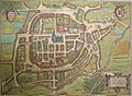
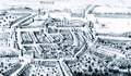
A 16th-century map of Braga, when the city was enclosed by its mediaeval wall. The large building in the centre is the Cathedral, while the Episcopal Palace and courtyards can be seen above the cathedral and the ancient Castle of Braga
-
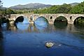
Ponte de Prozelo, Braga
-
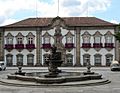
The 18th century municipal hall that houses the local government authority
-
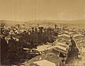
The skyline of Braga during the mid-19th century.
-
A 17th-century engraving of Braga, showing the walls of the city, which were progressively demolished to make way for new constructions
-
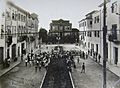
A view of Rua Júlio Lima at the beginning of the 20th century
-
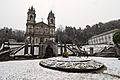
Snow in Braga. Picture: Sanctuary of Bom Jesus do Monte
-
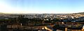
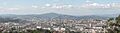
Panorama of Braga, as seen from the Picoto hill
-
A similar panorama taken from the Este River valley
-
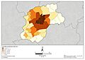
Population density of the civil parishes in the municipality of Braga (2021 data)
-
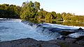
Beach in Cávado River, Braga
-
Braga, Portugal

.JPG)


.jpg)

.JPG)
.jpg)
See also
 In Spanish: Braga para niños
