Cape Verde facts for kids
Quick facts for kids
Republic of Cabo Verde
República de Cabo Verde (Portuguese)
|
|
|---|---|
|
|
|
|
Motto:
|
|
|
Anthem: Cântico da Liberdade (Portuguese)
(English: "Chant of Freedom") |
|
| Capital and largest city
|
Praia 14°54′59″N 23°30′34″W / 14.91639°N 23.50944°W |
| Official languages | Portuguese |
| Recognised national languages | Cape Verdean Creole |
| Religion
(2021)
|
|
| Demonym(s) | Cape Verdean or Cabo Verdean |
| Government | Unitary semi-presidential republic |
| José Maria Neves | |
| Ulisses Correia e Silva | |
| Legislature | National Assembly |
| Independence from Portugal | |
|
• Granted
|
5 July 1975 |
| Area | |
|
• Total
|
4,033 km2 (1,557 sq mi) (166th) |
|
• Water (%)
|
negligible |
| Population | |
|
• 2022 census
|
593,149 (172nd) |
|
• Density
|
147.1/km2 (381.0/sq mi) (89th) |
| GDP (PPP) | 2023 estimate |
|
• Total
|
|
|
• Per capita
|
|
| GDP (nominal) | 2023 estimate |
|
• Total
|
|
|
• Per capita
|
|
| Gini (2015) | ▼ 42.4 medium |
| HDI (2022) | medium · 131st |
| Currency | Cape Verdean escudo (CVE) |
| Time zone | UTC–1 (CVT) |
| Date format | dd/mm/yyyy |
| Driving side | right |
| ISO 3166 code | CV |
| Internet TLD | .cv |
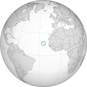
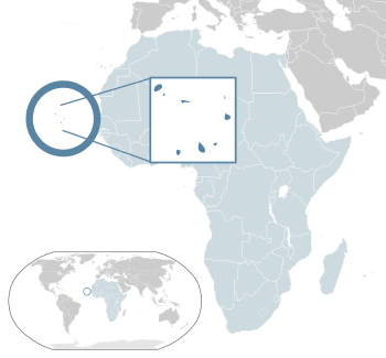
Cape Verde, also known as Cabo Verde, is an island nation in Africa. Its official name is the Republic of Cabo Verde. It is a group of islands located in the Atlantic Ocean. These islands are about 570 kilometers (354 miles) off the coast of West Africa.
The islands cover a total area of just over 4,000 square kilometers (1,557 square miles). They were formed by volcanoes. Cape Verde is part of a group of islands called Macaronesia.
Contents
What's in a Name?
The name "Cape Verde" comes from a Portuguese explorer named Dinis Dias. In 1445, he found a green peninsula (a piece of land almost surrounded by water) along the coast of Senegal. He named it Cabo Verde, which means "Green Cape" in Portuguese. This was because of the green plants in the area.
Dias didn't discover the Cape Verde Islands themselves, but rather this green cape on the African mainland. This cape is the westernmost point of the African continent.
A Look Back in Time
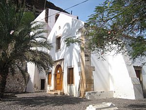
The first Europeans to reach the Cape Verde islands were the Portuguese explorers Diogo Gomes and Antonio da Noli in 1460. The islands were not inhabited by people at that time.
The first European settlement was started in 1462 on the island of Santiago. This island was divided into two areas. One of these, Ribeira Grande, became a place where cotton was grown. It also became a major trading post for enslaved people. Many enslaved people were brought here before being sent to the Americas.
The city of Ribeira Grande was attacked by pirates many times. Because of this, in 1712, the capital was moved to Praia, where it remains today. Cape Verde was a Portuguese colony until 1951. Then, Portugal changed its status to an "Overseas Province." In 1961, all Cape Verdeans were given full Portuguese citizenship.
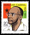
Cape Verde became independent from Portugal on July 5, 1975. The fight for independence was led by the African Party for the Independence of Guinea and Cape Verde (PAIGC). A national hero for both Cape Verde and Guinea-Bissau was Amílcar Cabral, who led this movement.
Exploring the Geography
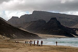
The Cape Verde islands are in the Atlantic Ocean. They are about 570 kilometers (354 miles) off the coast of West Africa. Nearby countries include Senegal, Gambia, and Mauritania. These islands are part of the Macaronesia ecological region. This region also includes the Azores, Madeira, Savage Islands, and Canary Islands. Cape Verde lies between 14°N and 18°N latitude and 22°W and 26°W longitude.
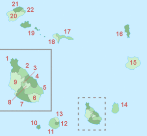
The country is an archipelago, which means a group of islands. It has a total area of 4,033 square kilometers (1,557 square miles). There are ten main islands, and nine of them are inhabited (people live on them). There are also many smaller islands called islets. The islands are divided into two groups based on the direction of the wind:
- Ilhas de Barlavento (Windward islands): These are the northern islands. From west to east, they are Santo Antão, São Vicente, Santa Luzia (no people live here), São Nicolau, Ilha do Sal, and Boa Vista. There are also small islets like Branco and Raso.
- Ilhas de Sotavento (Leeward islands): These are the southern islands. From east to west, they are Maio, Santiago, Fogo, and Brava. There are also several small islets around them.
The largest islands are Santiago in the southeast and Santo Antão in the northwest. Praia, the capital and largest city, is on Santiago. Mindelo, on São Vicente island, is the second largest city.
| Name | Population (2010) |
Area (km²) |
Highest point (m) |
|---|---|---|---|
| Boa Vista | 9,162 | 620 | Monte Estância (387) |
| Brava | 5,995 | 67 | Monte Fontainhas (976) |
| Fogo | 37,051 | 476 | Pico do Fogo (2,829) |
| Maio | 6,952 | 265 | Monte Penoso (436) |
| Sal | 25,765 | 216 | Monte Vermelho (406) |
| Santa Luzia | 0 | 35 | Monte Grande (395) |
| Santiago | 273,919 | 991 | Pico d'Antónia (1,394) |
| Santo Antão | 43,915 | 779 | Topo de Coroa (1,979) |
| São Nicolau | 12,817 | 388 | Monte Gordo (1,340) |
| São Vicente | 76,107 | 227 | Monte Verde (774) |
Extreme Points of Cape Verde
- North: Ponta do Sol, on Santo Antão island.
- South: Ponta Nhô Martinho, on Brava island.
- East: Ilhéu do Roque, on Boa Vista island.
- West: Ponta Chão de Morgado, on Santo Antão island.
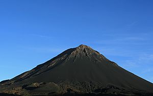
- Highest Mountain: Pico do Fogo, on Fogo island, which is 2,829 meters (9,281 feet) high.
Climate and Weather
Cape Verde enjoys sunshine for about 350 days a year! Temperatures usually stay between 21°C and 29°C (70°F and 84°F). A gentle wind (breeze) blows constantly from the ocean. The air is not very humid, usually between 40% and 60%.
The islands have two main seasons:
- The Tempo das Brisas ("Time of the winds") from October to mid-July.
- The Tempo das chuvas ("Rainy season") from August to September. During this time, there can be heavy rainfall.
The coolest months are January and February, with an average temperature of 21°C (70°F). Temperatures can sometimes drop to 16°C (61°F). September is the warmest month, with temperatures up to 36°C (97°F) and an average of 27°C (81°F).
The northern islands (Barlavento) are generally a bit cooler than the southern islands (Sotavento), where summers can be quite hot.
| Climate data for Cabo Verde : Praia | |||||||||||||
|---|---|---|---|---|---|---|---|---|---|---|---|---|---|
| Month | Jan | Feb | Mar | Apr | May | Jun | Jul | Aug | Sep | Oct | Nov | Dec | Year |
| Mean daily maximum °C (°F) | 25 (77) |
25 (77) |
25 (77) |
26 (79) |
27 (81) |
27 (81) |
28 (82) |
28 (82) |
28 (82) |
29 (84) |
27 (81) |
26 (79) |
27 (81) |
| Mean daily minimum °C (°F) | 20 (68) |
19 (66) |
20 (68) |
208 (406) |
21 (70) |
21 (70) |
23 (73) |
24 (75) |
25 (77) |
24 (75) |
23 (73) |
21 (70) |
22 (72) |
| Average precipitation mm (inches) | — | — | — | — | — | — | 10 (0.4) |
90 (3.5) |
20 (0.8) |
40 (1.6) |
— | — | 210 (8.3) |
| Source: Weatherbase.com [1] | |||||||||||||
The climate in Praia, Cape Verde, is classified as a Bwh climate. This means it is a Tropical and Subtropical Desert Climate.
Amazing Wildlife
Because Cape Verde is isolated, it has many unique species of animals and plants. These are called endemic species, meaning they are found nowhere else in the world. Many of these, especially birds and reptiles, are endangered because of human development.
Some endemic birds include Alexander's Swift, Bourne's Heron, the Raso Lark, the Cape Verde Warbler, and the Iago Sparrow. The islands are also a very important place for seabirds to breed, like the Cape Verde Shearwater. An example of an endemic reptile is the Cape Verde Giant Gecko.
How Cape Verde is Organized
Cape Verde is divided into 22 areas called municipalities (concelhos). These municipalities are then split into 32 smaller areas called parishes (freguesias).
- - Tarrafal
- - São Miguel
- - São Salvador do Mundo
- - Santa Cruz
- - São Domingos
- - Praia
- - Ribeira Grande de Santiago
- - São Lourenço dos Órgãos
- - Santa Catarina
- - Brava
- - São Filipe
- - Santa Catarina do Fogo
- - Mosteiros
- - Maio
- - Boa Vista
- - Sal
- - Ribeira Brava
- - Tarrafal de São Nicolau
- - São Vicente
- - Porto Novo
- - Ribeira Grande
- - Paúl
How Cape Verde is Governed
Cape Verde is a representative parliamentary republic. This means that citizens elect people to represent them in the government. The country's rules are set out in its constitution, which was first adopted in 1980.
The president is the head of state and is elected for a five-year term. The Prime Minister is the head of government. The Prime Minister is chosen by the National Assembly (the main law-making body) and then appointed by the President.
Economy and Resources
Cape Verde's economy mainly relies on farming and fishing. However, farming often faces challenges due to droughts. Important crops include coffee, bananas, sugar cane, and various fruits and vegetables.
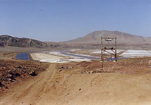
The industrial sector is still developing. It includes making spirits from sugar cane, clothes, shoes, paints, and varnishes. Tourism is also growing and is a key source of income. Fishing and canned fish production, along with salt extraction, are also important.
The main things Cape Verde exports are bananas, canned fish, frozen fish, lobsters, salt, and clothes. The national money is called the Cape Verdean escudo. Money sent home by Cape Verdeans living abroad is another big source of income for the country.
People of Cape Verde
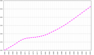
Cape Verde has a low rate of population growth and deaths compared to other similar countries. People in Cape Verde generally live long lives, with an average life expectancy of 66 years for men and 71 years for women.
About 500,000 people live in Cape Verde. However, it's estimated that another one million Cape Verdeans live in other countries. Most of them live in the United States, Western Europe, and other parts of Africa. Cape Verde has a young population, with the average age being about 23 years old.
Culture and Traditions
Cape Verdean culture is a special mix of European and African influences. Corn is a very important food in Cape Verde. The national dish is cachupa. This is a stew made with hominy (dried maize kernels), beans, and whatever meat or vegetables are available. Other common foods include rice, fish, potatoes, and manioc. A traditional breakfast is steamed cornbread, often eaten with honey and milk or coffee.
Grogue, a sugar cane liquor, is made on the islands and is a popular drink, especially among men. Cape Verdean music combines Portuguese, Caribbean, and African styles. Popular music types include morna, funaná, batuque, coladeira, and cola san jon.
Health and Healthcare
Cape Verde has a public health system provided by the government. This system includes many healthcare centers and three main hospitals. These hospitals are Hospital Agostinho Neto in Praia, Hospital Baptista de Sousa in São Vicente, and Hospital Regional de Santiago Norte in Assomada.
The government helps pay for public healthcare. However, people using the services usually pay a fee. This fee changes depending on what the person can afford.
Education for All
After gaining independence, the different governments of Cape Verde put a lot of effort into education. Because of this, the number of people who cannot read or write has gone down a lot. Today, almost all children of school age attend school.
Primary schooling lasts for six years and is required for all children. It is also free of charge. Education is provided through a network of public schools, from nursery school all the way to university. There are also several private schools at all levels of education.
Images for kids
-
Amílcar Cabral on a stamp of the former East Germany
-
Beach east of Curral Velho, Boa Vista
-
The small valley (or dale) of Principal, Santiago Island
-
Cape Verdean national flag carrier TACV
-
People in Santiago, the largest island in the country
-
Cape Verdeans are a very musical people; The Chã das Caldeiras group is an example.
-
Cesária Évora, Cape Verdean singer
-
Estádio Nacional de Cabo Verde in Praia
See also
 In Spanish: Cabo Verde para niños
 | Madam C. J. Walker |
 | Janet Emerson Bashen |
 | Annie Turnbo Malone |
 | Maggie L. Walker |


