
Senegal facts for kids
Quick facts for kids
Republic of Senegal
République du Sénégal
|
|
|---|---|
|
Coat of arms
|
|
|
Motto: "Un peuple, un but, une foi" (French)
"Wenn Askan, Benn Jubluwaay, Benn Pas-Pas" (Wolof) (English: "One People, One Goal, One Faith") |
|
|
Anthem: Le Lion rouge
(English: "The Red Lion") |
|
.svg)
Location of Senegal (dark green)
|
|
| Capital and largest city
|
Dakar 14°40′N 17°25′W / 14.667°N 17.417°W |
| Official languages | French |
| National languages |
|
| Ethnic groups
(2019)
|
|
| Religion
(2019)
|
|
| Demonym(s) | Senegalese |
| Government | Unitary presidential republic |
| Bassirou Diomaye Faye | |
| Ousmane Sonko | |
|
• President of the National Assembly
|
Malick Ndiaye |
| Legislature | National Assembly |
| Independence | |
|
• Republic established
|
25 November 1958 |
|
• Independence from France
|
20 June 1960 |
|
• Withdrawal from
the Mali Federation |
20 August 1960 |
|
• Dissolution of the Senegambia Confederation
|
30 September 1989 |
| Area | |
|
• Total
|
196,722 km2 (75,955 sq mi) (86th) |
|
• Water (%)
|
2.1 |
| Population | |
|
• 2024 estimate
|
|
|
• Density
|
96/km2 (248.6/sq mi) |
| GDP (PPP) | 2025 estimate |
|
• Total
|
|
|
• Per capita
|
|
| GDP (nominal) | 2025 estimate |
|
• Total
|
|
|
• Per capita
|
|
| Gini (2011) | 40.3 medium |
| HDI (2023) | low · 169th |
| Currency | West African CFA franc (XOF) |
| Time zone | UTC±00:00 (GMT) |
| Calling code | +221 |
| ISO 3166 code | SN |
| Internet TLD | .sn |

Senegal, also known as the Republic of Senegal, is a country on the western coast of Africa. It faces the Atlantic Ocean. Senegal is bordered by Mauritania to the north and Mali to the east. To the southeast is Guinea, and to the southwest is Guinea-Bissau.
Senegal almost completely surrounds The Gambia. The Gambia is a small country along the Gambia River. This river separates Senegal's southern area, Casamance, from the rest of the country. Senegal also shares a water border with Cape Verde. The capital city of Senegal is Dakar.
Contents
History of Senegal
In the 15th century, Portuguese explorers arrived at Gorée Island. This island is off the coast of Dakar. Later, in the 17th century, French and Dutch people also came to the island. These European countries used Gorée Island as a trading post.
For a time, the island was used in the trade of enslaved people from the mainland. These areas were controlled by the Wolof Empires. France later made slavery illegal. Around 1850, the French began to take control of the Wolof lands. By 1902, Senegal became part of the French colony called French West Africa.
In January 1959, Senegal joined with French Sudan. They formed the Mali Federation. This federation became fully independent on June 20, 1960. However, Senegal and Mali soon separated into two different nations. From 1982 to 1989, Senegal and The Gambia were united as Senegambia.
Geography and Climate

Senegal is located on the western side of Africa. It lies between 12° and 17°N latitude, and 11° and 18°W longitude.
The country is bordered by the Atlantic Ocean to the west. Mauritania is to the north, and Mali is to the east. Guinea and Guinea-Bissau are to the south. Inside Senegal, the country almost completely surrounds The Gambia. Only The Gambia's short Atlantic coastline is not surrounded.
Senegal's land is mostly flat, sandy plains. These plains are part of the western Sahel region. In the southeast, the land rises into small hills. Senegal's highest point is here, about 2.7 km southeast of Nepen Diakha. It is 648 meters (2,126 feet) high.
The Sénégal River forms the northern border. Other important rivers include the Gambia River and Casamance Rivers. The capital city, Dakar, is on the Cap-Vert peninsula. This is the westernmost point of mainland Africa.
The Cape Verde islands are about 560 km (348 miles) off Senegal's coast. Cap-Vert is a landmark near Dakar. It is at the base of "Les Mammelles," a 105-meter (344-foot) cliff. This is where Dakar, Senegal's capital, is located.
Senegal's Climate

Senegal has a tropical climate. It is warm all year round. There are clear dry and wet seasons. These seasons are caused by winds from the northeast in winter and southwest in summer. The dry season lasts from December to April. During this time, a hot, dry wind called harmattan blows.
Dakar gets about 600 mm (24 inches) of rain each year. Most of this rain falls between June and October. During these months, the highest temperatures are around 30°C (86°F). The lowest temperatures are about 24.2°C (75.6°F). From December to February, the highest temperatures average 25.7°C (78.3°F). The lowest temperatures are around 18°C (64°F).
Government and Politics
Senegal is a republic with a president. The president is chosen by adult voters every five years. This rule started in 2016. Before that, the term length changed a few times.
Senegal has more than 80 political parties. The country has a single parliament called the National Assembly of Senegal. It has 150 members. Senegal also has an independent court system. The highest courts for business matters are the constitutional council and the court of justice. The president chooses the members of these courts.
Economy and Industries
.jpg)
Senegal's main industries include making food, mining, and producing cement. They also make artificial fertilizer and chemicals. Other important industries are textiles, refining imported oil, and tourism.
Senegal exports many goods. These include fish, chemicals, cotton, and fabrics. They also export groundnuts and calcium phosphate. In 1998, India was the biggest buyer of Senegal's exports. Other important markets are the United States, Italy, and the United Kingdom.
Languages Spoken in Senegal
French is the official language of Senegal. People who have studied in school for several years usually speak French. This is because French is used for teaching. In 2022, about 26% of the population spoke French.
Most people also speak their own ethnic language. In Dakar, the capital, Wolof is a common language used by many different groups. Pulaar is spoken by the Fulas and Toucouleur people. The Serer language is also widely spoken. Even President Sall's wife is Serer.
The Jola languages are common in the Casamance region. Overall, Senegal has about 39 different languages. Several of these are recognized as "national languages." These include Balanta-Ganja, Arabic, Jola-Fonyi, Mandinka, Mandjak, Mankanya, Noon, Pulaar, Serer, Soninke, and Wolof.
English is taught in secondary schools. It is also part of many university programs. The Ministry of Education has a special office just for English.
Regions of Senegal
Senegal is divided into several regions:
- Dakar
- Diourbel
- Fatick
- Kaffrine
- Kaolack
- Kédougou
- Kolda
- Louga
- Matam
- Saint-Louis
- Sédhiou
- Tambacounda
- Thiès
- Ziguinchor
Largest Cities
Dakar, the capital, is the biggest city in Senegal. It has over two million people. The second largest city is Touba. It is a rural community with over half a million residents.
|
Largest cities or towns in Senegal
According to the 2013 Census |
||
|---|---|---|
| Rank | Name | Pop. |
| 1 | Dakar | 2,646,503 |
| 2 | Touba | 753,315 |
| 3 | Pikine | 317,763 |
| 4 | Kaolack | 233,708 |
| 5 | M'bour | 232,777 |
| 6 | Rufisque | 221,066 |
| 7 | Ziguinchor | 205,294 |
| 8 | Diourbel | 133,705 |
| 9 | Tambacounda | 107,293 |
| 10 | Louga | 104,349 |
Culture and Traditions
Senegal is famous for its storytelling tradition. Storytellers are called griots. They have kept West African history alive for thousands of years. They use words and music to share stories. Being a griot is a family tradition. It requires many years of training. Griots learn about family histories, general history, and music. They help share the voices of many generations in West African society.
The African Renaissance Monument was built in 2010 in Dakar. It is the tallest statue in Africa. Dakar also hosts a film festival called Recidak.
The Islamic festival of Eid al-Fitr, known as Tabaski, is very popular. Even though most people are Muslim, the Christian festival of Christmas is also celebrated. Christmas trees and decorations can be seen in Dakar.
Senegalese Cuisine
Senegal is next to the Atlantic Ocean, so fish is a very important food. Chicken, lamb, peas, eggs, and beef are also used in cooking. Pork is not eaten much because most of the population is Muslim.
Peanuts are Senegal's main crop. They are used in many recipes. Other common ingredients include couscous, white rice, sweet potatoes, lentils, black-eyed peas, and various vegetables. Meats and vegetables are usually stewed or marinated. Then they are poured over rice or couscous, or eaten with bread.
Popular fresh juices are made from bissap, ginger, or buoy. Buoy is the fruit of the baobab tree. Other fruit juices include mango and soursop. Desserts are very rich and sweet. They mix local ingredients with French cooking styles. Desserts are often served with fresh fruit. After dessert, people traditionally drink coffee or tea.
Music of Senegal

Senegal is known across Africa for its music. This is thanks to the popularity of mbalax. This music style comes from the Serer percussive traditions, especially the Njuup. Famous musicians like Youssou N'Dour and Omar Pene have made it popular.
Sabar drumming is very popular. The sabar drum is mostly used for special events like weddings. Another drum, the tama, is used by many different ethnic groups. Other famous Senegalese musicians include Ismael Lô, Cheikh Lô, Orchestra Baobab, Baaba Maal, Akon (US-born), Thione Seck, Viviane, Fallou Dieng, Titi, Seckou Keita and Pape Diouf.
Sports in Senegal


Senegalese people enjoy many sports. Wrestling and football are the most popular sports. Senegal will host the 2026 Summer Youth Olympics in Dakar. This will make Senegal the first African country to host an Olympic event.
Senegalese wrestling is the country's most popular sport. It has become a national passion. Traditionally, it helps many young men escape poverty. It is also the only sport recognized as developing independently of Western culture.

Football is very popular in Senegal. In 2022, the national team beat Egypt. They won the Africa Cup of Nations for the first time. They were also runners-up in 2002 and 2019.
Senegal became one of only five African teams to reach the quarter-finals of the FIFA World Cup. This happened in 2002, when they beat France in their first game. They qualified for the 2018 FIFA World Cup in Russia and the 2022 FIFA World Cup in Qatar.
Senegal has also been a strong basketball country in Africa. The men's team did very well at the 2014 FIBA World Cup. They reached the playoffs for the first time. The women's team has won 19 medals at 20 African Championships. This is more than double any other team. When Senegal hosted the 2019 FIBA Women's AfroBasket, 15,000 fans came to the Dakar Arena. This was a record for basketball attendance in Africa. Senegal was one of the first countries in Africa to have a competitive basketball league.
In 2016, the NBA announced it would open an Elite's Academy in Africa. It chose Senegal as the location.
The country hosted the Paris–Dakar rally from 1979 to 2007. The Dakar Rally was a tough off-road race. It went from Paris, France, to Dakar, Senegal. Competitors used special off-road vehicles to cross difficult terrain. The last race was in 2007. The 2008 rally was canceled due to safety concerns in Mauritania. The 2021 Ocean X-Prix of the electric off-road championship Extreme E was also held in Senegal.
Images for kids
-
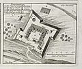
The Portuguese Empire was the first European power to colonize Senegal, beginning with the arrival of Dinis Dias in 1444 at Gorée Island and ending in 1888, when the Portuguese gave Ziguinchor to the French.
-
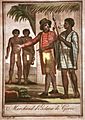
French slave traders in Gorée, 18th century
-
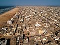
Aerial view of Yoff Commune, Dakar
-
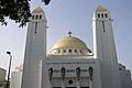
Our Lady of Victories Cathedral, a catholic church in Dakar
-
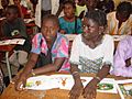
Students in Senegal


.jpg)


See also
 In Spanish: Senegal para niños
