
Sénégal River facts for kids


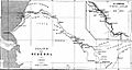
The Sénégal River is a long and important river in West Africa. It stretches for about 1,793 kilometers. This river forms a natural border between the countries of Senegal and Mauritania.
Long ago, people knew this river by different names. An ancient writer named Pliny the Elder called it Bambotus. This name meant "hippopotamus," because many of these animals lived there. Another old mapmaker, Claudius Ptolemy, called it Nias. Around 450 BC, a famous explorer named Hanno the Carthaginian visited the river. He was on a journey from Carthage to the Gulf of Guinea. People likely traded goods from this river all the way to the Mediterranean Sea in ancient times.
Contents
Where the River Starts
The Sénégal River begins when two smaller rivers meet. These are the Semefé River and the Bafing River. They join together in a place called Bafoulabé. Both the Semefé and Bafing rivers start in the country of Guinea.
The Bafing River flows through Mali. The Semefé River then forms part of the border between Mali and Senegal.
The River's Journey to the Ocean
As the Sénégal River gets closer to the sea, it flows through an area called Biffeche. There is also a large island in the river here. The city of Saint-Louis is built on this island.
After passing Saint-Louis, the river turns towards the south. A thin strip of sand separates the river from the Atlantic Ocean. This sand strip is known as the Langue de Barbarie. Finally, the Sénégal River flows into the Atlantic Ocean.
Important Dams on the River
The Sénégal River has two very important dams. One is the Manantali Dam, located in Mali. This dam creates a large reservoir of water. The other is the Maka-Diama Dam. It is found on the border between Mauritania and Senegal, close to the sea. The Maka-Diama Dam helps stop salty ocean water from flowing too far inland. This protects the fresh water used for farming and drinking.
How Much Water the River Carries
The Sénégal River collects water from a huge area of land. This area is about 483,181 square kilometers. Every year, about 8,000,000 cubic meters of water flow along the river. Several other rivers also join the Sénégal River. These include the Faleme River, the Karakoro River, and the Gorgol River.
Managing the River Together
In 1972, the countries of Mali, Mauritania, and Senegal created a special group. It is called the Organisation pour la mise en valeur du fleuve Sénégal (OMVS). This name means "Organization for the Development of the Senegal River." This group works together to manage the land and water around the river. They make sure the river is used wisely for everyone. The country of Guinea also joined this important organization in 2005.
Images for kids
-
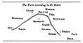
Western Nile (Senegal-Niger River) according to al-Bakri (1068)
-
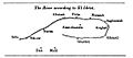
Western Nile (Senegal-Niger River) according to Muhammad al-Idrisi (1154)
-
Course of the "River of Gold" (Senegal-Niger) in the 1413 map of Mecia de Viladestes.
-
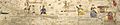
Slave trade along the Senegal River, kingdom of Cayor
-
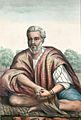
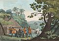
Moorish man from the Trarza region of the Senegal River Valley, 1853
-
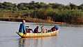
Boat on Senegal River
-
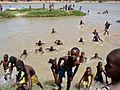
Young boys swimming in the Senegal River
-
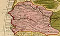
Senegambia region, detail from a map by Guillaume Delisle (1707).
-
Route of the Senegal, map from 1889


See also
 In Spanish: Río Senegal para niños
