
Mauritania facts for kids
Quick facts for kids
Islamic Republic of Mauritania
|
|
|---|---|
|
Motto: شرف، إخاء، عدل
"Honour, Fraternity, Justice" |
|
|
Anthem: النشيد الوطني الموريتاني
"National Anthem of Mauritania" |
|
.svg)
Location of Mauritania (in green) in western Africa
|
|
| Capital and largest city
|
Nouakchott 18°09′N 15°58′W / 18.150°N 15.967°W |
| Official languages | |
| Recognised national languages |
|
| Other languages | French |
| Ethnic groups | |
| Religion | Sunni Islam (official) |
| Demonym(s) | Mauritanian |
| Government | Unitary semi-presidential Islamic republic |
| Mohamed Ould Ghazouani | |
| Mokhtar Ould Djay | |
|
• President of the National Assembly
|
Mohamed Ould Meguett |
| Legislature | National Assembly |
| Independence | |
|
• Republic established
|
28 November 1958 |
|
• Independence from France
|
28 November 1960 |
|
• Current constitution
|
12 July 1991 |
| Area | |
|
• Total
|
1,030,000 km2 (400,000 sq mi) (28th) |
| Population | |
|
• 2024 estimate
|
4,328,040 (128th) |
|
• Density
|
3.4/km2 (8.8/sq mi) |
| GDP (PPP) | 2023 estimate |
|
• Total
|
|
|
• Per capita
|
|
| GDP (nominal) | 2023 estimate |
|
• Total
|
|
|
• Per capita
|
|
| Gini (2014) | ▼ 32.6 medium |
| HDI (2022) | low · 164th |
| Currency | Ouguiya (MRU) |
| Time zone | UTC (GMT) |
| ISO 3166 code | MR |
| Internet TLD | .mr |
|
|

.svg)
Mauritania, officially called the Islamic Republic of Mauritania, is a country in Northwest Africa. It borders the Atlantic Ocean to the west. Other neighbors include Western Sahara to the north, Algeria to the northeast, Mali to the east, and Senegal to the southwest.
Mauritania is the 11th largest country in Africa by land area. About 90% of its land is part of the Sahara Desert. Most of its 4.3 million people live in the warmer southern parts. The capital and largest city, Nouakchott, is on the Atlantic coast.
Even with many natural resources like iron ore and oil, Mauritania is a developing country. Its economy mainly relies on farming, raising animals, and fishing.
Contents
- Understanding Mauritania's Name
- A Brief History of Mauritania
- Exploring Mauritania's Geography
- How Mauritania is Governed
- Regions and Divisions
- Mauritania's Economy
- People and Population
- Major Cities in Mauritania
- Religion in Mauritania
- Languages Spoken in Mauritania
- Mauritanian Culture and Traditions
- Sports in Mauritania
- Images for kids
- See also
Understanding Mauritania's Name
Mauritania gets its name from an old Berber kingdom. This kingdom was important around 300 BC. Later, it became a Roman province called Mauretania. The word "Mauri" is also where the name for the Moors comes from.
A Brief History of Mauritania

Berber people lived in the area that is now Mauritania by the 200s AD. Arab tribes moved here in the late 600s. They brought Islam and the Arabic language with them.
In the early 1900s, France took control of Mauritania. It became part of French West Africa. Mauritania became an independent country in 1960. Since then, it has had some changes in government, including times when the military was in charge.
Exploring Mauritania's Geography


.jpg)
Mauritania is in western Africa. It is mostly flat, with huge, dry plains. These plains cover about 1,030,700 square kilometers. The country borders the North Atlantic Ocean. It is between Senegal and Western Sahara. It also borders Mali and Algeria.
Mauritania is part of both the Sahel and the Maghreb regions. About three-quarters of the country is desert or semi-desert. The desert has been growing since the mid-1960s due to long periods of severe drought.
The country has a series of cliffs that divide the plains. These cliffs also separate sandstone plateaus. The highest is the Adrar Plateau, which is about 500 meters (1,640 feet) high. Oases, which are places with water from springs, are found at the bottom of some cliffs.
Tall, isolated peaks rise above the plateaus. Smaller ones are called guelbs, and larger ones are kedias. The Richat Structure, also known as the "Eye of the Sahara," is a famous circular rock formation. It is in the north-central part of the country. Kediet ej Jill is the highest peak, at 915 meters (3,002 feet).
The plateaus slowly go down towards the northeast. This area is called the El Djouf, or "Empty Quarter." It is a huge region of large sand dunes that blend into the Sahara Desert. To the west, near the ocean, are areas of clay plains and sand dunes. Some of these dunes move because of strong winds.
Natural plant life grows in belts from east to west. This depends on how much rain an area gets. You can find small tropical forests along the Senegal River. There are also brush and savanna areas in the southeast. Only sandy desert is found in the center and north.
Mauritania has seven different natural areas, called ecoregions. These include savannas, deserts, and woodlands. The Richat Structure is a unique rock formation. It looks like giant concentric circles. It is located in the Adrar Plateau near Ouadane.
Wildlife and Natural Habitats
Mauritania's wildlife is influenced by two main regions. The northern part is in the Palearctic realm. This extends south from the Sahara. The southern part is in the Afrotropic realm. Many birds migrate from the Palearctic to Mauritania for winter.
Most of the north is part of the Palearctic realm. It is mainly the Sahara desert and coastal areas. South of this is the Afrotropical realm. This means animals from Africa are common here. South of the Sahara, there are steppes and woodlands. These blend into the Sahelian acacia savanna. The very southern part of the country has West Sudanian savanna.
Wetlands are very important in Mauritania. The two main protected areas are the Banc d'Arguin National Park and the Diawling National Park. Banc d'Arguin protects rich coastal and marine areas. It is next to the dry Sahara Desert. Diawling National Park is in the northern part of the Senegal River delta. Other wetlands in Mauritania often dry up. They depend on seasonal rainfall.
How Mauritania is Governed
The Mauritanian Parliament has one main group, called the National Assembly. It has 176 members. These members are chosen by voters for a five-year term. Each member represents a specific area.
Before August 2017, there was also an upper house called the Senate. It had 56 members. Most were elected by local councils. The Senate was removed after a public vote in 2017.
The President of Mauritania is chosen directly by the people. They serve a five-year term and can serve a second term. The President then chooses the Prime Minister.
Regions and Divisions
Mauritania's government is organized into ministries and special agencies. The Ministry of Interior manages a system of regional governors. This system is similar to the one used in France. Mauritania is divided into 15 regions, called wilaya or régions.
The central government has a lot of control. However, elections since 1992 have led to some local control. These regions are further divided into 44 smaller areas called moughataa.
Here are the regions and their capitals:
| Region | Capital | # |
|---|---|---|
| Adrar | Atar | 1 |
| Assaba | Kiffa | 2 |
| Brakna | Aleg | 3 |
| Dakhlet Nouadhibou | Nouadhibou | 4 |
| Gorgol | Kaédi | 5 |
| Guidimaka | Sélibaby | 6 |
| Hodh Ech Chargui | Néma | 7 |
| Hodh El Gharbi | Ayoun el Atrous | 8 |
| Inchiri | Akjoujt | 9 |
| Nouakchott-Nord | Dar-Naim | 10 |
| Nouakchott-Ouest | Tevragh-Zeina | 10 |
| Nouakchott-Sud | Arafat | 10 |
| Tagant | Tidjikdja | 11 |
| Tiris Zemmour | Zouérat | 12 |
| Trarza | Rosso | 13 |
Mauritania's Economy
Mauritania has many natural resources, but its economy is still developing. Most people rely on farming and raising animals. Many farmers and nomads moved to cities in the 1970s and 1980s. This was due to repeated droughts.
Mauritania has large amounts of iron ore. This makes up almost half of all its exports. Gold and copper mines are also opening in the country. In 2015, Mauritania produced 9 metric tons of gold.
The country's first deepwater port opened near Nouakchott in 1986. In recent years, droughts and poor economic management have led to a lot of foreign debt.
People and Population
As of 2024, Mauritania has about 4.3 million people. Around one-third of them live in the capital city, Nouakchott. The population is made up of three main groups. These are the Beidane (white Moors), Haratin (black Moors), and West Africans.
About 30% of the people are Bidhan. They speak Hassaniya Arabic and have Arab-Berber roots. The Haratin make up about 35% to 40% of the population. They are descendants of the first people who lived in the Tassili n'Ajjer and Acacus Mountains.
The remaining 30% are mostly West African ethnic groups. These include the Halpulaar (Fulbe), Soninke, Bambara, and Wolof.
Major Cities in Mauritania
Template:Largest cities of Mauritania
Religion in Mauritania

Almost all people in Mauritania are Muslim. Most follow the Sunni branch of Islam. In 2020, there were an estimated 10,000 Christians in Mauritania.
There are strict rules about religious freedom in Mauritania. It is one of the few countries where not believing in God can be punished by death.
Languages Spoken in Mauritania
Arabic is the official and national language of Mauritania. The local Arabic spoken is called Hassaniya. It has many words from Berber and is different from the formal Arabic used in official communication.
Even though it's not official, French is used for government work. It is also used for teaching in schools. French is common in media, business, and among educated people.
Mauritanian Culture and Traditions

Silversmiths from the Tuareg and Mauritanian cultures have created beautiful jewelry. This traditional Berber jewelry is worn by both women and men. Mauritanian jewelry is often more decorated. It can have special pyramid shapes.
Many movies and TV shows have been filmed in Mauritania. These include Fort Saganne (1984) and The Fifth Element (1997). Other films are Winged Migration (2001) and Timbuktu (2014). The TV show The Grand Tour (2024) also filmed there.
The TV show Atlas of Cursed Places (2020) talked about Mauritania. It suggested that the Richat Structure might be the lost city of Atlantis. This structure is a series of rings in the Western Sahara.
The T'heydinn is a part of the Moorish oral tradition. The libraries in Chinguetti hold thousands of old manuscripts.
Sports in Mauritania
Sports in Mauritania are shaped by its desert and Atlantic coast. Football is the most popular sport. Athletics and basketball are also well-liked. The country has several football stadiums. One is the Stade Municipal de Nouadhibou.
In 2012, Mauritania's football team was ranked very low. But they qualified for the 2019 Africa Cup of Nations. In 2023, they beat Sudan in the AFCON 2023 qualifiers. This was a big achievement.
Mauritania has received international help for sports facilities. Morocco has promised to build a sports complex in the country.
Images for kids
-
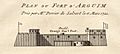
The Portuguese Empire ruled Arguin (Portuguese: Arguim) from 1445, after Prince Henry the Navigator set up a feitoria, until 1633.
-
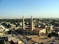
Nouakchott is the capital and the largest city of Mauritania. It is one of the largest cities in the Sahara.
-
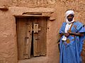
Chinguetti was a center of Islamic scholarship in West Africa.
-
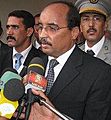
Mohamed Ould Abdel Aziz in his hometown, Akjoujt, on 15 March 2009
-
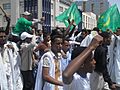
2011–12 Mauritanian protests

.jpg)


See also
 In Spanish: Mauritania para niños
