
Senegal River facts for kids
Quick facts for kids Senegal River |
|
|---|---|

Boats on the Senegal River, on the border between Senegal and Mauritania
|
|

Map of the Senegal River drainage basin.
|
|
| Other name(s) | Wolof: Dexug Senegaal Arabic: نهر السنغال French: Fleuve Sénégal |
| Country | Senegal, Mauritania, Mali |
| Physical characteristics | |
| Main source | Bakoy River Menien-Koma, Guinea 760 m (2,490 ft) 11°50′N 9°45′W / 11.833°N 9.750°W |
| 2nd source | Bafing River Foranruel, Guinea 750 m (2,460 ft) 10°23′42″N 12°08′06″W / 10.395°N 12.135°W |
| River mouth | Atlantic Ocean Saint-Louis, Senegal 0 m (0 ft) 15°56′17″N 16°30′29″W / 15.938°N 16.508°W |
| Length | 1,086 km (675 mi) |
| Basin features | |
| Basin size | 337,000 km2 (130,000 sq mi) |
The Senegal River is a long river in West Africa. It flows for about 1,086 kilometers (675 miles). A big part of the river forms the border between the countries of Senegal and Mauritania.
The river's basin, which is the land area that drains into the river, covers about 270,000 square kilometers (104,000 square miles). On average, 680 cubic meters (24,000 cubic feet) of water flow through it every second.
Important rivers that flow into the Senegal River are the Falémé River, Karakoro River, and the Gorgol River. After passing Kaédi, the river splits into two parts. The left part is called the Doué. It runs next to the main river for about 200 kilometers (120 miles) before joining it again near Podor.
In 1972, Mali, Mauritania, and Senegal created an organization called the Organisation pour la mise en valeur du fleuve Sénégal (OMVS). This group helps manage the river and its basin. Guinea joined the OMVS in 2005. The OMVS is also looking into making the river easier for boats to travel on. This would help landlocked Mali get goods to the Atlantic Ocean.
The animals living in the Senegal River are similar to those in the Gambia River. Only three types of frogs and one fish species are found only in this area.
The river has two large dams. The Manantali Dam is in Mali, and the Maka-Diama Dam is downstream, near the border of Mauritania and Senegal. There is also the Félou Hydroelectric Plant, which makes electricity from the river's power. A new power plant, the Gouina Hydroelectric Plant, started being built in 2013.
Contents
Exploring the Senegal River

The Senegal River starts from two smaller rivers, the Semefé (Bakoye) and Bafing. Both of these rivers begin in Guinea. They meet at a place called Bafoulabé in Mali.
From there, the Senegal River flows west and then north. It passes through rocky areas called Talari Gorges and over the Gouina Falls. Then, it flows more calmly past Kayes, where another river, the Kolimbiné, joins it.
After joining with the Karakoro, the Senegal River forms part of the border between Mali and Mauritania. Near Bakel, the Falémé River flows into it. The Falémé River also starts in Guinea and forms part of the border between Guinea and Mali.
The Senegal River then flows through dry lands in northern Senegal, still forming the border with Mauritania. At Kaedi, the Gorgol from Mauritania joins it. The river continues through Boghé and reaches Richard Toll, where the Ferlo river from Senegal's Lac de Guiers joins in.
Near its mouth, the river passes Rosso and flows around the island city of Saint-Louis. It then turns south. A thin strip of sand called the Langue de Barbarie separates the river from the Atlantic Ocean before it finally flows into the ocean.
Dams and River Management
The Senegal River has two main dams. The Manantali Dam in Mali helps control the river's flow and store water. The Maka-Diama Dam is closer to the sea, on the Mauritania-Senegal border. This dam stops salt water from the ocean from flowing too far up the river.
Between these two large dams, there is the Félou Hydroelectric Plant. This power station was first built in 1927 and was updated in 2014. Another power plant, the Gouina Hydroelectric Plant, started construction in 2013 at Gouina Falls. These plants use the river's water to create electricity.
The Senegal River's basin covers about 270,000 square kilometers (104,000 square miles). It has an average flow of 680 cubic meters (24,000 cubic feet) per second. The main rivers that feed into it are the Falémé River, Karakoro River, and Gorgol River.
Downstream from Kaédi, the river splits into two branches. The left branch, called the Doué, runs next to the main river to the north. After about 200 kilometers (120 miles), these two branches meet again a few kilometers downstream of Pondor. The long piece of land between these two branches is known as the Île á Morfil.
In 1972, Mali, Mauritania, and Senegal created the Organisation pour la mise en valeur du fleuve Sénégal (OMVS) to manage the river. Guinea joined this group in 2005.
Today, the river is not used much for transporting goods or people. However, the OMVS is studying how to create a wider channel, about 55 meters (180 feet) wide. This channel would go from Ambidédi in Mali to Saint-Louis, a distance of about 905 kilometers (562 miles). This would give Mali, which has no coastline, a direct way to reach the Atlantic Ocean.
River Life
The animals that live in the Senegal River basin are very similar to those found in the Gambia River basin. Because of this, scientists often group them together as one ecoregion called the Senegal-Gambia Catchments.
Even though there are many different types of animals, only three species of frogs and one type of fish are found only in this specific ecoregion. This means they are unique to this river system.
History of the Senegal River
The Senegal River was known to ancient civilizations around the Mediterranean Sea. Some old writings called it Bambotus or Nias. A famous explorer named Hanno the Carthaginian visited the area around 450 BCE. People traded goods from this region to the Mediterranean world for a long time.
Early Arab Accounts
In the early Middle Ages (around 800 CE), trade routes across the Sahara Desert helped connect the Senegal River region with the Mediterranean world again. Arab geographers, like al-Masudi (957) and al-Idrisi (1154), wrote some of the first descriptions of the river.

Early Arab geographers thought the upper Senegal River and the upper Niger River were connected. They believed they formed one large river flowing from east to west, which they called the "Western Nile." This was because some parts of the Senegal River's source are close to the Niger River in Mali and Guinea. They even thought it might be a branch of the Egyptian Nile River.
Later Arab geographers, like Ibn Said al-Maghribi (1274), called the Senegal River the "Nile of Ghana." Because the Senegal River reached into the heart of the gold-producing Ghana Empire and later the Mali Empire, traders across the Sahara Desert gave it the nickname "River of Gold." Stories about this "River of Gold" made European merchants very interested.
Maps and Explorers

The "River of Gold" started appearing on European maps in the 14th century. These maps often showed it flowing into the Atlantic Ocean. Some maps, like the 1367 chart by Domenico and Francesco Pizzigano, even showed a large "Island of Gold" in the middle of the river. This "island" likely referred to the Bambuk-Buré goldfield, an area rich in gold.
The 1413 map by Mecia de Viladestes showed a detailed picture of what Europeans knew about the Senegal River at the time. It called the river "River of Gold" and noted that people collected gold from its shores. The map also showed towns and leaders along the river, like the emperor (mansa) of Mali, Mansa Musa, holding a gold nugget.
_in_1413_Mecia_de_Viladestes_map.jpg)
European Arrival
Christian Europeans soon tried to find a sea route to the mouth of the Senegal River. In 1291, the Genoese Vivaldi brothers set out but were never heard from again. In 1346, Jaume Ferrer also tried to find the "River of Gold" but disappeared.

In the 1420s, Prince Henry the Navigator of Portugal put a lot of effort into reaching the river. In 1434, his captain Gil Eanes finally sailed past Cape Bojador, a difficult point for sailors. In 1445, another Portuguese captain, Nuno Tristão, reached the Langue de Barbarie, a sandy strip near the river's mouth. He saw that the land changed from desert to trees and the people changed from Berbers to Wolof. He reported finding the "Land of the Blacks."
Soon after, in the same year, Dinis Dias became the first known European since ancient times to reach the mouth of the Senegal River by sea. The next year, in 1446, Estêvão Afonso was the first European to actually sail up the Senegal River.
Between 1448 and 1455, the Portuguese captain Lourenço Dias started regular trade with the Wolof kingdoms of Waalo and Cayor along the river. They traded European goods, especially horses, for gold and slaves.
By the 1460s, the river was commonly called "Senega" on maps. People believed it was connected to the Biblical Gihon River or the ancient "Niger" river.
What's in a Name?
The name "Senegal" has a few possible origins. One idea, from the 16th century, is that the Portuguese named it after a local Wolof chief they traded with. However, this is unlikely.

A popular theory, first suggested in 1853, is that "Senegal" comes from the Wolof phrase sunu gaal, which means "our canoe." The story says that when a Portuguese captain asked local fishermen the river's name, they thought he was asking about their boat and replied, "it is our canoe." This idea is popular in modern Senegal because it sounds nice and suggests national unity.
More recent historians think the name "Senegal" might come from Azenegue. This was the Portuguese name for the Saharan Berber Zenaga people who lived north of the river.
Another strong idea is that "Senegal" is much older and comes from "Sanghana." This was a city described by an Arab historian in 1068, located at the mouth of the Senegal River. This city was the capital of a local kingdom. The name "Isingan" was also used for the Wolof kingdom of Cayor.
Some Serer people from the south believe the river's name comes from the Serer words "Sene" (from Rog Sene, their Supreme Deity) and "O Gal" (meaning "body of water").
See also
 In Spanish: Río Senegal para niños
- Futa Toro
Images for kids
-
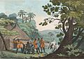
People and activities along the Senegal River in the kingdom of Cayor.
-
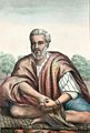
A Moorish man from the Trarza region near the Senegal River, drawn in 1853.
-
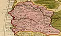
A map detail from 1707 showing the Senegambia region.
-
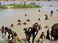
Young boys swimming in the Senegal River.


