
Hanno the Navigator facts for kids
Quick facts for kids
Hanno the Navigator
|
|
|---|---|
| Nationality | Carthaginian |
| Occupation | Explorer, possibly king |
| Years active | 5th century BC |
| Known for | Naval exploration of the western coast of Africa |
|
Works
|
A periplus about his journey |
| Family | Magonid |
Hanno the Navigator was a famous explorer from Carthage (an ancient city in North Africa). He lived around 500 BC. Hanno is best known for his amazing sea journey along the western coast of Africa.
The only record of his voyage is a special travel log called a periplus. This log was originally written in the Punic language, but we only have a Greek translation of it today. Some people even thought Hanno might have been a king!
Historians have tried to figure out exactly where Hanno's ships went. Some experts believe his expedition reached as far south as Gabon. Others think he only went as far as southern Morocco.
Contents
The name Hanno was common for many people from Carthage. Ancient writers who talked about Hanno the Navigator didn't give much clear information about him. Some called him a king. Others used words like "leader" or "commander." The Greek translation of Hanno's travel log calls him a basileus. This word can mean "king," but it was also used for important officials in Carthage.
Most scholars agree that Hanno lived in the 5th century BC. They also believe he was part of the important Magonid family. One historian, R.C.C. Law, thinks Hanno was the son of Hamilcar I.
Hanno's Amazing Travel Log
Hanno's travel log, or periplus, is still around today in Greek copies. The original version, written in the Punic language, is now lost. The Greek translation is shorter and has 101 lines. Even though it has some small mistakes, it likely came from a real Carthaginian text.
This periplus is very special. It's one of the few ancient exploration stories written by the explorer himself. It's also the closest thing we have to a piece of Carthaginian writing. The text was translated into Greek around the 5th century BC. Over many centuries, Greek and Roman scribes copied this translation. Two copies still exist today, from the 9th and 14th centuries.
What the Periplus Says

This summary is based on a translation by Al. N. Oikonomides. It shows his ideas, which might be different from other scholars.
The story begins: "This is the report of the periplus of Hanno, king of the Carthaginians, into the Libyan areas of the earth beyond the Pillars of Hercules which he dedicated in the sanctuary of Kronos."
Hanno set out with 60 ships and 30,000 people. His goal was to start new cities along the African coast.
- First, he founded one city.
- Then, he sailed further and founded five more cities.
- When they reached a river, the Carthaginians met the Lixitae, a friendly nomadic tribe.
- They learned about the nearby Ethiopians. Hanno took some Lixitae with him as interpreters and sailed again.
- At a small island called Kerne, another settlement was built.
- Around a lake named Chretes and an unnamed river, they found wild people and large wild animals.
- After returning to Kerne, they sailed even further south along Africa. Here, they found Ethiopians whose language even the Lixitae interpreters could not understand.
- Sailing on, Hanno found a "huge opening of the sea" where they could see fires.
- At a bay called the "Horn of the West," they landed on an island where humans lived. The Carthaginians quickly left because they were scared.
- They reached lands with many flames and a very tall mountain.
- Finally, they arrived at a bay called the "Horn of the South." Here, there was an island with hostile, hairy people called "Gorillas."
- Three of these "Gorillas" were killed. Their skins were brought back to Carthage.
- The expedition ran out of supplies and could not sail any further. The periplus suddenly ends here, without saying how they returned home.
Why the Text Might Be Changed
Both ancient and modern writers have looked closely at Hanno's travel log. Many attempts to find the places described, based on the distances and directions, have not worked. Scholars think the Carthaginians might have changed the real story. This could have been to protect their trade secrets. Other countries wouldn't be able to find the places, but Carthaginians could still brag about their achievements.
One idea is that the Punic manuscript translated into Greek was already incomplete. It might have left out the later parts of the original journey. The story ends very suddenly. It also seems impossible for the trip to end exactly as described. So, the last two lines might have been added to make up for a missing part of the story.
Hanno's Great Expedition
Carthage sent Hanno with a fleet of 60 ships. His mission was to explore and start new settlements along the northwestern coast of Africa. He sailed through the Straits of Gibraltar. He founded or rebuilt seven settlements along the African coast in what is now Morocco. He also explored much further along the Atlantic coast. Hanno met different local people on his journey. Some welcomed him, while others did not.
The gold trade was very important to the Carthaginian empire since the 5th century BC. This trade might have been the main reason Carthage explored sub-Saharan Africa. Hanno's voyage was likely meant to secure the gold route to West Africa.
Many modern scholars have studied Hanno's voyage. They try to understand the original account better. William Smith noted that 30,000 people were on the expedition. The main goal was to found Carthaginian towns. However, some scholars wonder if that many people really went with Hanno. They suggest 5,000 might be a more accurate number.
Historian R. C. C. Law points out how hard it is to know the exact route. Some experts believe Hanno reached the Gabon area. Others think he went no further than southern Morocco. Harden says most agree the expedition reached at least Senegal. Because the periplus is not very clear, estimates for the voyage's distance range from under 700 miles (1,100 km) to at least 3,000 miles (4,800 km). Some agree he could have reached Gambia.
However, Harden also mentions disagreement about the farthest point Hanno reached. Was it Sierra Leone, Cameroon, or Gabon? He notes that the description of Mount Cameroon, a 4,040-meter (13,250 ft) volcano, matches Hanno's description better than Mount Kakulima in Guinea, which is only 890 meters (2,920 ft). But another scholar, Warmington, prefers Mount Kakulima, thinking Mount Cameroon is too far away.
Raymond Mauny, a historian, argued in 1955 that ancient sailors could not have sailed south in the Atlantic past Cape Bojador. He said that ancient geographers knew about the Canary Islands but nothing further south. Ships with square sails and no stern rudder could sail south. But the winds and currents would make it impossible to return from Senegal to Morocco. Ships with oars might be able to return north, but with great difficulty. Mauny believed Hanno did not get further than the Drâa. He suggested that objects found on Mogador Island were from an expedition described in another text, the Periplus of Pseudo-Scylax. He also noted that no proof of Mediterranean trade further south had been found yet. Mauny suggested looking for ancient remains on islands like Cape Verde or île de Herné (Dragon Island near Dakhla, Western Sahara). Ancient adventurers might have been stranded and settled there.
The "Gorillai"
The end of the periplus describes an island with hairy, wild people. Hanno's crew tried to capture the men but failed. They took three of the women, but these women were so fierce that they were killed. Their skins were brought back to Carthage. These skins were kept in the Temple of Juno (a goddess like Tanit or Astarte) when Hanno returned. According to Pliny the Elder, the skins were still there when the Romans destroyed Carthage in 146 BC, about 350 years after Hanno's trip.
Hanno's interpreters from an African tribe called these people Gorillai (in Greek, Γόριλλαι). In 1847, a type of ape was scientifically described and named the gorilla after these Gorillai. However, the scientists did not say for sure that Hanno's Gorillai were the same as the gorillas we know today.
What Ancient Writers Said
The Roman writer Pliny the Elder (who lived around 23–79 AD) and the Greek writer Arrian of Nicomedia (around 86–160 AD) knew about Hanno's text.
Pliny the Elder's Account
Pliny might have been vague about the exact date because he didn't know it. His claim that Hanno sailed all the way around Africa, reaching Arabia, is not believed by today's scholars.
Herodotus's Account
The Greek historian Herodotus, who wrote around 430 BC, described Carthaginian trade on the Moroccan coast in his book Histories (4.196). However, it's not clear if he knew about Hanno's specific voyage.
Hanno's Legacy
Modern Recognition
The lunar crater Hanno on the Moon is named after him.
How Hanno's Voyage Was Studied
In the 16th century, during the Age of Discovery when European exploration was booming, scholars became very interested in Hanno's voyage. Even back then, people debated how far Hanno actually traveled.
Images for kids
-
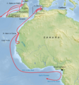
A map showing one idea of Hanno's route, possibly reaching Mount Cameroon.
See also
 In Spanish: Hannón el Navegante para niños
