
Santiago, Cape Verde facts for kids

Map of Santiago, Cape Verse
|
|
 |
|
| Geography | |
|---|---|
| Location | Atlantic Ocean |
| Coordinates | 15°04′N 23°38′W / 15.067°N 23.633°W |
| Archipelago | Cape Verde |
| Area | 1,003.71 km2 (387.53 sq mi) |
| Length | 75 km (46.6 mi) |
| Width | 35 km (21.7 mi) |
| Highest elevation | 1,394 m (4,573 ft) |
| Administration | |
| Demographics | |
| Population | 273,919 |
| Pop. density | 272.9 /km2 (706.8 /sq mi) |
Santiago, also called Santiagu in Cape Verdean Creole, is the biggest island in Cape Verde. Its name means "Saint James" in Portuguese. It is a very important island for farming. About half of all people in Cape Verde live here. Praia, the capital city of Cape Verde, is located on Santiago.
Santiago is part of a group of islands in the Atlantic Ocean called Macaronesia. These islands have similar natural environments, known as ecosystems.
Contents
History of Santiago Island
A navigator from Genoa, named António de Noli, found Santiago island around 1460. He worked for Prince Henry of Portugal. In 1462, de Noli started the first capital city of the islands, called Ribeira Grande. Today, this city is known as Cidade Velha.
Population on Santiago
As of 2010, about 273,919 people lived on Santiago island. This means there were about 272.9 people for every square kilometer.
The largest city on the island is Praia, which is also the capital of Cape Verde. In 2010, Praia had a population of 131,602 people.
Geography of Santiago
Santiago is in the southern group of islands called Sotavento. It is about 40 kilometers (25 miles) west of Maio island. It is also about 50 kilometers (31 miles) east of Fogo island.
Santiago island covers an area of 1,003.71 square kilometers (387.53 square miles). It is about 75 kilometers (47 miles) long from north to south. It is also about 35 kilometers (22 miles) wide from east to west.
The island has many mountains, but it is a bit flatter in the southeast. There are two main volcanic mountain ranges:
- Serra da Malagueta: This mountain range is in the northern part of the island.
- Serra do Pico de Antónia: This range is in the southern part of the island. It stretches from the southeast to the northwest. The highest point on the island, Pico de Antónia, is here. It is 1,394 meters (4,573 feet) high.
There are two natural parks on the island. They help protect the plants and animals in these mountain areas:
- Parque Natural de Rui Vaz e Serra de Pico de Antónia
- Parque Natural de Serra da Malagueta
Climate in Praia
Praia, located on the southeast coast, has a tropical and subtropical Desert climate. This type of climate is known as Bwh in the Köppen climate classification system.
The average temperature in Praia for the whole year is 24.4°C (75.9°F). The warmest month is usually August, with an average temperature of 26.7°C (80.1°F). The coolest month is typically January, with an average temperature of 22.2°C (72.0°F).
Praia gets about 210.8 millimeters (8.3 inches) of precipitation each year. August is usually the wettest month, with about 99.1 millimeters (3.9 inches) of rain. March is typically the driest month, with almost no rain. On average, there are 49 days with some precipitation. September has the most rainy days (7 days), while December has the fewest (2 days).
Administration of Santiago
Santiago island is divided into 9 areas called municipalities (conselhos). These municipalities are further divided into 10 smaller areas called parishes (freguesias).
Images for kids
-
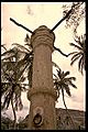
The pillory in Cidade Velha.
-
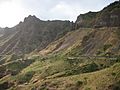
The Serra Malagueta mountain range in the northern part of the island of Santiago, Cape Verde
-
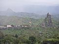
Santiago island. The wetter climate of the interior and the eastern coast contrasts with the dryer one in the south/southwest coast


See also
 In Spanish: Isla de Santiago para niños
