
São Nicolau, Cape Verde facts for kids
|
Native name:
Saniclau
Nickname: Ilha de Chiquinho
|
|
|---|---|
 |
|

São Nicolau
Location in Cape Verde
|
|

São Nicolau
Location in Cape Verde
|
|
| Geography | |
| Location | Atlantic Ocean |
| Coordinates | 16°36′54″N 24°16′16″W / 16.615°N 24.271°W |
| Area | 343 km2 (132 sq mi) |
| Length | 44.5 km (27.65 mi) |
| Width | 22.0 km (13.67 mi) |
| Highest elevation | 1,312 m (4,304 ft) |
| Highest point | Monte Gordo |
| Administration | |
| Concelhos (Municipalities) | Ribeira Brava, Tarrafal de São Nicolau |
| Largest settlement | Ribeira Brava |
| Demographics | |
| Population | 12,424 (2015) |
| Pop. density | 36.2 /km2 (93.8 /sq mi) |
São Nicolau is a beautiful island in Cape Verde, a country made of islands in the Atlantic Ocean. It's part of the Barlavento group, which means "windward" islands. In 2015, about 12,400 people called São Nicolau home. The two main towns on the island are Ribeira Brava and Tarrafal de São Nicolau.
Contents
Discovering São Nicolau
This island was first found by Europeans in 1461 or 1462. A Portuguese explorer named Diogo Afonso discovered it. He also found two other nearby islands around the same time: São Vicente and Santo Antão.
Island Life and Geography
São Nicolau is known for its green valleys and tall mountains. The highest point on the island is Monte Gordo, which stands 1,312 meters (about 4,304 feet) tall. The island is about 44.5 kilometers (27.7 miles) long and 22 kilometers (13.7 miles) wide.
Main Towns
- Ribeira Brava: This is the biggest town on São Nicolau. It's located in a valley and is known for its charming old buildings.
- Tarrafal de São Nicolau: This town is on the coast and is a fishing center. Many people here work with the sea.
Nature and Climate
São Nicolau has a dry climate, but it gets enough rain to support some farming. The island's landscapes range from dry coastal areas to more humid mountain regions. This variety allows different plants and animals to live there.
Images for kids
-
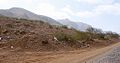
A cobblestone-paved road with the view of the island's mountain.
-
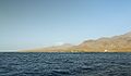
Coast of the island of São Nicolau
-
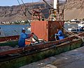
Tarrafal de São Nicolau fishing boat


See also
 In Spanish: São Nicolau para niños
