
Boa Vista, Cape Verde facts for kids
|
Nickname: Ilha das dunas (island of the dunes)
|
|
|---|---|
 |
|
 |
|

Boa Vista
Location in Cape Verde

Boa Vista
Location in Africa
|
|
| Geography | |
| Location | Atlantic Ocean |
| Coordinates | 16°6′N 22°48′W / 16.100°N 22.800°W |
| Archipelago | Cape Verde |
| Area | 631.1 km2 (243.7 sq mi) |
| Length | 30.8 km (19.14 mi) |
| Width | 28.9 km (17.96 mi) |
| Highest elevation | 387 m (1,270 ft) |
| Highest point | Monte Estância |
| Administration | |
| Municipality | Boa Vista |
| Largest settlement | Sal Rei |
| Demographics | |
| Population | 14,451 (2015) |
| Pop. density | 22.9 /km2 (59.3 /sq mi) |
Boa Vista (which means "good view" in Portuguese) is a desert-like island that belongs to the Cape Verde Islands. It is the third largest island in Cape Verde, covering about 631 square kilometers.
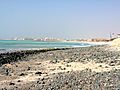
Boa Vista is the closest Cape Verde island to the African continent, only about 450 kilometers from Senegal. The capital city of Boa Vista, Sal Rei, is located on the northwest side of the island. Boa Vista is mostly known for its beautiful beaches, sea turtles, and traditional music.
Contents
Geography

Boa Vista is the third biggest island in Cape Verde, after Santo Antão and Santiago. It covers 631.1 square kilometers. You can find it south of Sal island and north of Maio island. The island is mostly flat, but it has several hills. The tallest point is Monte Estância, which is 387 meters high. Other hills include Monte Santo António and Morro Negro.
Boa Vista is famous for its many large beaches. Some popular ones are Atalanta, Chaves, and Santa Mónica. The northernmost tip of the island is Ponta do Sol, and the westernmost tip is Ponta Varandinha. The main river, Ribeira do Rabil, has the largest river basin in all of Cape Verde. Boa Vista is also known for its desert, Deserto de Viana, and its large areas of sand dunes. There are also several small, uninhabited islands around Boa Vista, with Ilhéu de Sal Rei being the largest.
History
The island of Boa Vista was not inhabited by people when it was discovered in 1460 by explorers António de Noli and Diogo Gomes. For a long time, the only activity on the island was raising wild cattle. The first settlement, now called Povoação Velha, was started in 1620 because of its salt deposits. English traders were the main ones who collected this salt.
Around 1820, after many pirate attacks, people moved to a new settlement called Porto Inglês, which was later renamed Sal Rei. This new town had been founded in the late 1700s. Like much of Cape Verde, the salt industry on Boa Vista relied heavily on forced labor. A special group was set up in Boa Vista in 1842 to try and end this, but it wasn't fully stopped until 1876. Until 1935, the municipality of Boa Vista also included the island of Sal. Cape Verde became an independent country in 1975.

Government
The island of Boa Vista is managed by one local government area called the Concelho da Boa Vista. This area is divided into two smaller parts called freguesias (civil parishes): Santa Isabel and São João Baptista. The main city and seat of this government is Sal Rei.
Population
In the 1830s, about 4,000 people lived on Boa Vista. By 2015, the population had grown to 14,451. Most people live in Sal Rei, but there are also smaller villages with fewer people. With about 23 people per square kilometer, Boa Vista is the least crowded island in Cape Verde.
The people of Boa Vista come from many different backgrounds. The largest group are Creoles, who have mixed African and European family roots. This is because many Portuguese settlers formed families with people from the African continent during the time Portugal ruled the island.
| Year | Population |
|---|---|
| 1940 |
2,779
|
| 1950 |
2,985
|
| 1960 |
3,263
|
| 1970 |
3,569
|
| 1980 |
3,372
|
| 1990 |
3,452
|
| 2000 |
4,193
|
| 2010 |
8,554
|
| 2015 |
14,451
|
Economy
In the past, people on Boa Vista made a living by collecting salt and farming dates. Today, they still grow dates, but tourism is a much bigger part of the economy. Many people work in the tourism industry as taxi drivers, hotel staff, or by selling souvenirs in Sal Rei. The money from tourism has grown a lot since the international airport opened in 2007. There are now several hotels and beach resorts on the island.
Transport
The main airport on Boa Vista is Aristides Pereira International Airport, which is about 5 kilometers southeast of Sal Rei. You can also travel to and from the island by ferry from the port of Sal Rei.
The island has 64 kilometers of national roads. The main road connects Sal Rei and Rabil.
Nature
Boa Vista doesn't have as many different plants and animals as some other Cape Verde islands, like Santiago or Santo Antão, which are wetter. Only 3% of Boa Vista is covered by forests. However, a large part of the island (37%) is a protected area, which is the highest percentage among all the islands in Cape Verde where people live.
There are 14 protected areas on Boa Vista. These include beaches that are very important nesting spots for loggerhead sea turtles and different kinds of birds. The island is also home to some unique species that are found nowhere else, such as the Boa Vista wall gecko (Tarentola boavistensis) and certain types of sea snails (like Conus boavistensis).
Gallery
-
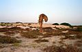
Boa Vista landscape.
-
Praia de Cabral, Boa Vista, Cape Verde
-
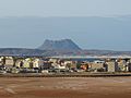
The capital, Sal Rei
-
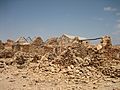
Ruins of the abandoned village Curral Velho.
-
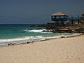
Sal Rei beach


Sports
There are several football (soccer) clubs on Boa Vista, which are part of the Boa Vista Regional Football Association.
Notable residents
- Aristides Pereira, Cape Verde's first president
- Germano Almeida, a Cape Verdean writer
See also
 In Spanish: Isla de Boa Vista para niños
