
Manchester city centre facts for kids
Quick facts for kids Manchester City Centre |
|
|---|---|
| Central Business District | |
 Aerial view of Manchester city centre from the south, looking north. |
|

Manchester City Centre
|
|
| Population | 17,861 (2011) |
| OS grid reference | SJ839980 |
| • London | 163 mi (262 km) SE |
| Metropolitan borough | |
| Metropolitan county | |
| Region | |
| Country | England |
| Sovereign state | United Kingdom |
| Post town | MANCHESTER |
| Postcode district | M1, M2, M3, M4 |
| Dialling code | 0161 |
| Police | Greater Manchester |
| Fire | Greater Manchester |
| Ambulance | North West |
| EU Parliament | North West England |
| UK Parliament |
|
Manchester City Centre is the main business area of Manchester in North West England. It's a busy place, home to many shops, offices, and fun activities. In 2011, about 17,861 people lived in the city centre area.
This important part of Manchester grew from a Roman fort called Mamucium around 79 AD. It was built near the Medlock and Irwell rivers. Later, it became the town of Manchester. The city centre was a key place during the Industrial Revolution. It became famous for the cotton trade, with grand buildings like the Royal Exchange. After the cotton trade slowed down and during World War II, the city centre faced tough times. But it bounced back! The CIS Tower, built in 1962, was once the tallest building in the UK.
Today, Manchester city centre is a major transport hub for Greater Manchester. Millions of people can reach it within an hour. A big event, the 1996 Manchester bombing, led to a huge effort to rebuild and improve the city centre. This helped it become a lively place for shopping, entertainment, offices, and city living. Its economy mainly relies on shops and services.
Contents
- Manchester's Past: A Journey Through Time
- Exploring Manchester's Layout
- Unique Areas of the City Centre
- Castlefield: Where History Meets Modern Life
- Northern Quarter: A Creative Hub
- Central Retail District: Shopping Paradise
- Spinningfields: The Business Heart
- Piccadilly: The Transport Hub
- Peter's Fields (Civic Quarter): Important Buildings and History
- Chinatown: A Taste of the Far East
- Canal Street: The Gay Village
- Unique Areas of the City Centre
- Getting Around Manchester City Centre
- Manchester's Economy: Shops and Fun
Manchester's Past: A Journey Through Time

Manchester started as a small civilian settlement next to a Roman fort called Mamucium. This fort was built around 79 AD on a high spot near the Medlock and Irwell rivers. It was a good place to defend against local tribes. After the Romans left Britain, people moved closer to where the Irwell and Irk rivers meet.
During the Middle Ages, the area we now call the city centre was known as the township of Manchester. There was even a medieval castle, first mentioned in 1184. It was owned by the Grelley family, who were the local barons. Later, a college for priests was built there in 1421. This building eventually became Chetham's School of Music, which is still there today!
Exciting Plans for the Future
Manchester city centre is a busy place for over 2.5 million people in the Greater Manchester area. Many new projects are planned to make it even better:
- St Peter's Square Makeover: This square, where Manchester Central Library is, will get a huge upgrade. It will become more pedestrian-friendly. There will also be a new memorial for the Peterloo Massacre of 1819.
- One St Peter's Square: A new tall office building is being built here. It will have 14 floors of modern office space. It's right across from the Midland Hotel and Central Library.
- Manchester Victoria station Upgrade: This train station is getting a big makeover. A new roof is being built, and old parts of the station are being cleaned up. The work started in 2013.
- NOMA Project: The Co-op is turning a large area of Manchester into a new space. It will have shops, offices, and homes. Their new headquarters will also be there.
- River Street Tower: A new 125-meter skyscraper was approved in 2012. It's designed by Ian Simpson. This building will be one of the tallest outside London.
There are also plans to expand the city centre northwards. This will connect Victoria and Piccadilly stations even better.
Exploring Manchester's Layout

The city centre is known by a few names: Central Manchester, the City Centre, or Manchester Central. It's generally the area inside Manchester's main ring road. This area is the commercial heart of Greater Manchester. It works closely with nearby Salford and Trafford for city planning and transport.
Unique Areas of the City Centre

Manchester city centre grew very quickly during the Industrial Revolution. Because of this, it doesn't have a perfect, planned layout. However, many areas have their own special feel. You can find old industrial warehouses, grand civic buildings, and modern developments. These unique areas are protected as "conservation areas" by Manchester City Council.
The council says these areas are important for Manchester's identity. They show the city's past and add to its beauty. New buildings are designed to fit in with these older parts of the city.
Castlefield: Where History Meets Modern Life
Castlefield is in the southwest part of the city centre. It's near Deansgate and the River Irwell. This area has the sites of the old Roman fort and the first inter-city railway station. It's the only Urban Heritage Park in the UK. You can see many old 19th-century warehouses and docks here. These were used to move goods during Manchester's industrial boom.
Today, Castlefield is a peaceful place with waterside bars and pubs. A famous building here is Manchester Liverpool Road station. It was the first station for the Liverpool and Manchester Railway in 1830. The old station building and a warehouse are now part of the Museum of Science and Industry (MOSI). For many years, Castlefield was considered for UNESCO World Heritage Status because of its important industrial history.
Northern Quarter: A Creative Hub

The Northern Quarter is in the northwest, near Victoria Station and Piccadilly Gardens. It's known for its alternative and artistic vibe. This area used to be the main shopping district. But when the Manchester Arndale shopping centre opened, it became quieter.
In the late 1980s, it was renamed the Northern Quarter. The idea was to bring new life to the area. Now, it's a popular spot for unique shops, cool bars, restaurants, and nightclubs. Many of these places are independent businesses.
Central Retail District: Shopping Paradise

The Manchester Arndale shopping centre opened in 1975. This shifted the main shopping area to Market Street and nearby streets. Even though some people didn't like its design, the Arndale is very popular. It gets 41 million visitors each year. It's the biggest city centre shopping mall in the UK.
This area was rebuilt after the 1996 bombing. It now includes Manchester Cathedral, Shambles Square, and Exchange Square. Big stores like Selfridges and Marks & Spencer have large shops here. Other shops are on nearby Deansgate and King Street.
Spinningfields: The Business Heart

Spinningfields is in the west, near Deansgate. It's the main business district of Manchester city centre. The idea for this area started in 1997. Developers wanted to create a special business hub after the 1996 bombing. The area is named after an old narrow street.
Spinningfields is famous for its modern, glass buildings, mostly offices. In 2010, it had 35% of the city centre's top office space. Nearly 20,000 people work for 44 companies here. Important buildings include 1 The Avenue and the Civil Justice Centre, known for its unique design.
This area also has many popular restaurants and bars. It has become a lively place, especially after work hours. The money made from shops and entertainment in Spinningfields grew from £10 million in 2008 to £50 million in 2014.
Piccadilly: The Transport Hub

Piccadilly is the city centre's main transport hub. You can find train, tram, and bus services all within a five-minute walk. It's usually very busy with people traveling to and from the city centre. The area is dominated by Piccadilly Gardens. This is the largest public square in the centre. It was redeveloped in the early 2000s.
For over 150 years, a hospital called Manchester Royal Infirmary was on this site. It closed in 1914 and was later pulled down. A public garden was created, which is why it's called Piccadilly Gardens. The area has its own tram station and a large bus station.
Peter's Fields (Civic Quarter): Important Buildings and History
-
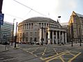
Manchester Central Library
-
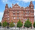
Midland Hotel
-
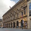
The Free Trade Hall


.jpg)
Peter's Fields, now known as St Peter's Square, is a civic area. It has many important buildings and monuments. These include Manchester Central Library, the Midland Hotel, and Manchester Town Hall. The council calls it "perhaps the greatest collective accolade to Manchester's original modern heritage."
The square is famous for the Peterloo Massacre in 1819. This was when cavalry charged into a large crowd of people. They had gathered to demand changes to how people were represented in government. A monument will be built by 2019 to mark the 200th anniversary of this important event. The square has also been redeveloped with new office buildings. The Cenotaph (a war memorial) was moved in 2014. The St Peter's Square tram stop will also be improved.
Chinatown: A Taste of the Far East

Chinatown is an area south of Piccadilly Gardens. It's full of Asian restaurants and shops. It's the second largest Chinatown in the United Kingdom. The first Chinese settlers came to Manchester in the early 1900s. Many worked in laundries. Manchester's first Chinese restaurant opened in 1948.
More Chinese people came to Manchester in the 1950s after World War II. They helped fill job shortages. By the 1970s, other Chinese businesses opened, like medicine shops and supermarkets. The area has kept its Far Eastern feel ever since. In 1987, a beautiful archway called a paifang was put up. It was a gift to the Chinese community.
Canal Street: The Gay Village

Canal Street is often called the Gay Village. It's east of Portland Street, with the Rochdale Canal running through it. This area has many bars, clubs, and other places. Many of them are for the gay community. The area has been linked to the gay community since the early 1900s. This was even when homosexuality was against the law.
Getting Around Manchester City Centre

Manchester City Centre has excellent transport links.
Train Stations
There are four main train stations in the city centre: Piccadilly, Victoria, Oxford Road, and Deansgate.
- Manchester Piccadilly station is the biggest station. It has 14 train platforms and 2 tram platforms. It's on the southeast side of the city centre, near Piccadilly Gardens.
- Manchester Victoria station is the main station for trains from the north and west of Greater Manchester. It also has tram platforms. Victoria is in the northwest of the city centre, near the Manchester Arena. It had a big £44 million renovation that finished in 2015.
- Manchester Oxford Road serves the southern part of the city centre. It's near the University of Manchester and Manchester Metropolitan University.
- Deansgate is in the southwest, near Castlefield. It's also close to the Beetham Tower and the Great Northern complex. You can easily walk to the tram stop from here.
Metrolink Trams
The Metrolink is a light rail tram service in Central Manchester. Trams usually run every 6 minutes during busy times. They connect the city centre to many places across Greater Manchester. As of 2021, there are eight lines. They connect to places like Altrincham, Ashton-under-Lyne, Bury, East Didsbury, Eccles, Manchester Airport, MediaCityUK, Rochdale and the Trafford Centre. A new tram line was recently built through the city centre.
Here are the Metrolink stops in the city centre:
- Deansgate-Castlefield
- Exchange Square
- Market Street
- Piccadilly
- Piccadilly Gardens
- Shudehill
- St Peter's Square
- Victoria
Second City Crossing (2CC)
To help with more trams and services, a new tram route was built through the city centre. It's called the 2CC. It runs from Victoria station to St Peter's Square. Work on this route started in 2014 and caused some street closures.
Bus and Coach Services
There are two main bus stations in the city centre: Manchester Piccadilly bus station and Shudehill Interchange. They offer local bus services to all 10 boroughs of Greater Manchester. Some buses also go to nearby counties like Cheshire and Lancashire.
- Piccadilly Gardens bus station mainly serves the south and east of Greater Manchester.
- Shudehill Interchange mainly serves the north and west of Greater Manchester.
Chorlton Street coach station offers long-distance coach services. These coaches go to cities all over Great Britain.
Manchester's Economy: Shops and Fun

Deansgate and Market Street are the main shopping streets. King Street is known for its fancy shops. There's also the huge indoor Manchester Arndale Centre. Manchester city centre has several large department stores like Marks and Spencer and Selfridges.
The city centre also has many fun places. The Printworks is a big entertainment complex. It has a cinema, bars, clubs, and restaurants. The Northern Quarter is known for its cool, independent shops and cafes.
The city centre has many public spaces. Piccadilly Gardens has fountains and green areas. Exchange Square is near Urbis, which is now the National Football Museum. Both Piccadilly and Exchange Square are used for public events. Two of the city centre's oldest buildings, The Old Wellington Inn and Sinclair's Oyster Bar, were moved and rebuilt in 1999 to create Shambles Square next to Manchester Cathedral.
You can find a wide variety of restaurants in the city centre. There are also many hotels, like the Midland.
Leisure and Entertainment

Manchester city centre has many nightclubs. The gay village is around the Canal Street area. It hosts an annual Gay Pride Festival. There's also a large Chinatown with many Asian restaurants. The Northern Quarter is known for its creative vibe and many bars. You can also find live music venues there.
There are two major theatres in the city centre: the Palace Theatre (opened 1891) and the Manchester Opera House (opened 1912). The Royal Exchange is a famous theatre company. It's known for its unique 'the round' stage layout. The Cornerhouse is a place for visual arts and films. A new building for Cornerhouse and Library Theatre will open in 2015.
Manchester Art Gallery, opened in 1824, gets over half a million visitors every year. It's one of the largest art galleries outside London. The Manchester Museum of Science and Industry in Castlefield explores the UK's industrial past, focusing on Manchester. The People's History Museum looks at the social history of Manchester and the UK.


