Geography of Greater Manchester facts for kids
Greater Manchester is a busy area in the United Kingdom. It's a metropolitan county, which means it's a large area with many towns and cities close together. Most of Greater Manchester is made up of urban areas (cities and towns), but it also has some green spaces and countryside.
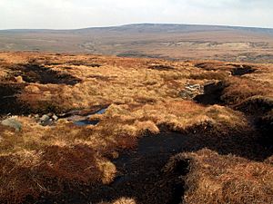
This county covers about 492.7 square miles (1,276 square kilometers). On its eastern side, you'll find the Pennines, which are a range of hills. There are also other hills called the West Pennine Moors in the west. Several rivers flow through Greater Manchester, including the Mersey, Irwell, and Tame. The highest point in Greater Manchester is Black Chew Head, which stands 542 meters (1,778 feet) above sea level.
Greater Manchester isn't just one big city. It's made up of ten main areas, each with its own important town centre. This makes it a very complex place, with lots of different communities and a busy transport system.
Contents
Exploring Greater Manchester's Towns
Greater Manchester is divided into ten different areas called metropolitan boroughs. Each borough has a main town or city that acts as its centre. Here's a look at some of the key towns and cities within these boroughs:
Highest Points in Greater Manchester

The highest spot in Greater Manchester is Black Chew Head. It's 542 meters (1,778 feet) above sea level. Each of the ten boroughs also has its own highest point.
Here are the highest points for each borough:
| Rank | Metropolitan borough | Height (m) | Name |
|---|---|---|---|
| 1 | Oldham | 542 | Black Chew Head |
| 2 | Tameside | 497 | Hoarstone Edge |
| 3 | Rochdale | 474 | Blackstone Edge |
| 4 | Bolton | 445 | Winter Hill |
| 5 | Bury | 415 | Holcombe Moor |
| 6 | Stockport | 327 | Mellor Moor |
| 7 | Wigan | 156 | Billinge Hill |
| 8 | Salford | 115 | Greenheys |
| 9 | Manchester | 108 | Heaton Park |
| 10 | Trafford | 70 | The Devisdale |
Understanding the Land: Geology of Greater Manchester
The ground beneath Greater Manchester is made up of rocks from different periods in Earth's history. Most of the area sits on sandstones and mudstones. These rocks are covered by thick layers of clay, sand, and gravel left behind by glaciers about 15,000 years ago.
Older rocks, called Millstone Grit, can be found in the northeast, forming uplands like the moors near Rochdale and Oldham. Above these are layers of rock called Coal Measures, where towns like Oldham, Rochdale, Bolton, and Wigan are built.
Earthquakes in Greater Manchester
In late 2002, Greater Manchester experienced a series of small earthquakes. More than 100 tremors were recorded in just a few months. The strongest one was a magnitude 3.9 earthquake. Scientists believe these quakes were caused by rocks moving deep underground along natural cracks called faults.
History of Coal Mining
People started digging for coal in Greater Manchester as early as the 13th century. However, coal mining really took off during the Industrial Revolution. Canals like the Bridgewater Canal were built to transport coal cheaply to Manchester and the River Mersey.
In some areas, like Oldham, coal seams were very close to the surface. As mining technology improved, deeper mines were dug. Coal mining continued in the western part of the area until the 1960s and stopped completely in north Manchester in the late 1970s.
Greater Manchester's Urban Areas
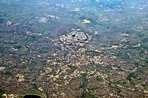
The Greater Manchester Urban Area is a large connected area of towns and cities. It includes most of Greater Manchester but also some places just outside the county, like Wilmslow in Cheshire. It doesn't include all towns within Greater Manchester, such as Wigan, which has its own separate urban area.
Weather in Greater Manchester
Greater Manchester has a mild maritime climate, similar to most of the UK. This means it has cool summers and mild winters. The area gets about 806.6 mm (31.76 inches) of rain each year, which is less than the UK average.
Snowfall is not very common in the main built-up areas because of the "urban warming" effect. However, the hills around the county, like the Pennines, get more snow. Sometimes, roads leading out of the county can even close due to heavy snowfall.
Plants and Animals in Greater Manchester
Even though Greater Manchester is very urban, it has a lot of natural beauty and wildlife. There are many different habitats, including woodlands, grasslands, moorlands, wetlands, and river valleys. These areas are home to a wide variety of plants and animals.
Organisations work to protect these natural spaces. There are 21 Sites of Special Scientific Interest (SSSI) in Greater Manchester, which are important places for wildlife. For example, Astley and Bedford Mosses are old peat bogs, and the Wigan Flashes are wetlands created by old coal mining areas.
Common Plants
You can find common plants like clover, sorrel, nettle, and thistle growing wild. In the uplands, like Saddleworth Moor, you'll see lots of common heather. The Rochdale Canal is home to a rare aquatic plant called Floating Water-plantain.
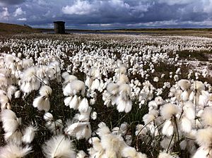
In 2002, Common cottongrass, a plant with fluffy white plumes, was chosen as the county flower of Greater Manchester.
Wild Animals and Their Life Cycle
The grey squirrel is one of the most common wild mammals in Greater Manchester. Hedgehogs and bats are also often seen in gardens.
Among birds, the house sparrow, common starling, and common blackbird are very common. You might also spot Eurasian magpies and feral pigeons. The South Pennines area is especially important for birds like the European golden plover, curlew, merlin, and twite.
 | William Lucy |
 | Charles Hayes |
 | Cleveland Robinson |


