
Radcliffe, Greater Manchester facts for kids
Quick facts for kids Radcliffe |
|
|---|---|
 A prominent landmark, St Thomas and St John with St Philip Church |
|

Radcliffe
|
|
| Population | 29,950 |
| OS grid reference | SD785075 |
| • London | 170 mi (274 km) SE |
| Metropolitan borough | |
| Metropolitan county | |
| Region | |
| Country | England |
| Sovereign state | United Kingdom |
| Post town | MANCHESTER |
| Postcode district | M26 |
| Dialling code | 0161 |
| Police | Greater Manchester |
| Fire | Greater Manchester |
| Ambulance | North West |
| EU Parliament | North West England |
| UK Parliament |
|
Radcliffe is a busy market town in Greater Manchester, England. It's located in the Irwell Valley, about 7 miles (11 km) northwest of Manchester. The town is also about 3 miles (5 km) southwest of Bury. The old Manchester Bolton & Bury Canal runs through the town.
People have lived in Radcliffe for a very long time. Signs of activity from the Mesolithic period (Stone Age), Roman times, and the Norman era have been found here. A Roman road even passed through the area. Radcliffe is mentioned in the famous Domesday Book as "Radeclive." In the Middle Ages, it was a small area with the Church of St Mary and the Radcliffe Tower. Both of these buildings are very old and important.
Radcliffe had lots of coal, which was perfect fuel for the Industrial Revolution. This helped the town grow with cotton spinning and papermaking factories. By the mid-1800s, Radcliffe was a key mill town. It had many cotton mills, bleachworks, and good transport links by road, canal, and railway.
In 2011, about 29,950 people lived in Radcliffe. Today, it's mostly a place where people live. Many of the old cotton mill buildings are now used by small businesses.
Contents
- Exploring Radcliffe's Past
- How Radcliffe is Governed
- Radcliffe's Location and Landscape
- Who Lives in Radcliffe?
- Radcliffe's Economy and Shops
- How Has Radcliffe's Population Changed?
- Important Buildings and Places
- Getting Around Radcliffe
- Learning in Radcliffe
- Places of Worship
- Sports and Fun in Radcliffe
- Public Services in Radcliffe
- Famous People from Radcliffe
- Radcliffe's Culture and Fun
- Images for kids
- See also
Exploring Radcliffe's Past
What's in a Name?
The name Radcliffe comes from old English words: read and clif. These words mean "the red cliff or bank" and refer to the red cliffs along the River Irwell. The Domesday Book from 1086 called it "Radeclive." Over time, the spelling changed a bit, but the meaning stayed the same. The Radcliffe family, who were important in the area, even took their name from the town.
Early Settlements and Roman Roads
The very first people lived here around 6,000 BC during the Mesolithic period. They likely stayed for parts of the year. In 1949, archaeologists found signs of ancient activity at Radcliffe Ees, a flat area by the River Irwell. They thought it might have been a lake village. Later, in 1961, more digging found sharpened posts and wooden tools. In 1911, a stone axe-hammer was found in the river, showing more signs of early human life.
During the Roman period, a Roman road ran through the area. It connected the Roman forts of Mamucium (Manchester) and Bremetennacum (Ribchester). This road followed the modern border between Radcliffe and Bury.
After the Norman conquest of England in the 1000s, Radcliffe became a parish and township. It was one of only four parishes in the area mentioned in the Domesday Book. Radcliffe started as two small villages: Radcliffe, near the Church of St Mary and Radcliffe Tower, and Radcliffe Bridge, where a crossing over the Irwell was located.
Radcliffe During the Industrial Revolution


Radcliffe's first factories appeared after 1680. People worked from home, weaving wool and linen or bleaching fabrics. In 1780, Robert Peel built the town's first factory. It used water power from the River Irwell to spin and weave cotton.
Conditions in these early factories were tough. Children, some bought from workhouses, worked long hours and were often locked in. Robert Peel himself said conditions were "very bad." An outbreak of typhoid in 1784 led to doctors inspecting the factory. Their report helped lead to the Factory Act of 1802, which aimed to improve factory hygiene. Over time, conditions did get better.
Radcliffe had a lot of coal underground, which was a great source of fuel. Coal mining started as early as 1246. At first, miners dug shallow "bell pits." But with steam engines, they could dig much deeper. Radcliffe once had about 50 coal pits! Most closed by the end of the 1800s. The last legal coal mining in Radcliffe stopped in 1949.
The town was home to many textile mills. There were about 60 textile mills and 15 spinning mills, plus 18 bleachworks. However, other industries like mining and paper making were also very important for jobs.
Radcliffe became famous for its paper industry. The East Lancashire Paper Mill, founded in 1860, provided much-needed jobs. It made paper for printing and writing. The Radcliffe Paper Mill, started during the First World War, made paper for roofing felt. After World War II, this mill employed over 600 people.
Other businesses included making bricks, chimney pots, and even motor vehicles until the late 1950s. During the Second World War, factories in Radcliffe made parts for weapons, aircraft, and tanks.
Radcliffe After the Factories
From the 1950s, Radcliffe's textile industry started to shrink. The large paper mills also closed down by the end of the 20th century. Pioneer Mill, which was the last cotton mill in Radcliffe, stopped weaving in 1980.
Even though many old factories are gone, Radcliffe still has many old Victorian and Edwardian houses. New homes have also been built where old factories used to be. Radcliffe became part of the Metropolitan Borough of Bury in 1974.
How Radcliffe is Governed

.jpg)
Radcliffe has had different ways of being governed over the years. In 1866, the Radcliffe Local Board of Health was set up. This group of 12 people made sure the town was clean and healthy.
In 1894, Radcliffe became an urban district within Lancashire. This meant it had its own local council with 24 members. The Radcliffe Town Hall was built in 1911 and was the main building for the council.
In 1935, Radcliffe became a municipal borough, which gave it more power. But in 1974, under a new law, Radcliffe became part of the Metropolitan Borough of Bury.
Today, Radcliffe is divided into three areas for voting: Radcliffe North, Radcliffe East, and Radcliffe West. It's part of the Bury South area for the UK Parliament.
Radcliffe's Location and Landscape
 |
Bolton | Tottington | Bury | |
| Little Lever | Unsworth | |||
| Kearsley | Clifton | Whitefield |

Radcliffe is located in the Irwell Valley, with the River Irwell flowing through it. The towns of Bury and Bolton are nearby. Manchester city centre is about 6.5 miles (10.5 km) to the south-southeast.
The River Irwell has been very important for Radcliffe's growth, providing water for its industries. Radcliffe E'es, a flat area along the river, is now empty land where a new school is planned. The land in Radcliffe slopes down towards the River Irwell.
Radcliffe is surrounded by green spaces. The River Roch joins the Irwell just east of the town. The Irwell flows from east to west, dividing the town into north and south sides. The town centre is on the north side of the valley. Several bridges cross the river, including road bridges and old railway viaducts.
Who Lives in Radcliffe?
| Radcliffe compared | |||
|---|---|---|---|
| 2001 UK census | Radcliffe | Bury (borough) | England |
| Total population | 34,239 | 180,608 | 49,138,831 |
| White | 96.2% | 93.9% | 91.0% |
| Asian | 2.1% | 4.0% | 4.6% |
| Black | 0.3% | 0.5% | 2.3% |
| Christian | 73.5% | 73.7% | 71.7% |
| Buddhist | 0.1% | 0.1% | 0.3% |
| Hindu | 0.4% | 0.4% | 1.1% |
| Jewish | 6.7% | 4.9% | 0.5% |
| Muslim | 1.7% | 3.7% | 3.1% |
| Sikh | 0.1% | 0.1% | 0.7% |
| Other religions | 0.1% | 0.2% | 0.3% |
| No religion | 10.2% | 10.2% | 14.6% |
| Religion not stated | 7.1% | 6.7% | 7.7% |
In 2001, Radcliffe had a population of 34,239 people. There were slightly more females than males. Most people were married or single. About 31.1% of adults aged 16-74 had no formal qualifications.
Radcliffe's neighborhoods are like suburbs of Bury and Manchester. This means many people who live here might work or have connections to those bigger towns. The people living in Radcliffe come from a mix of backgrounds, including working-class families and middle-class families.
Radcliffe's Economy and Shops
Radcliffe's first market opened in 1851. The town used to have many Co-op stores, with the largest being a four-story building built in 1877. The current market hall, built in 1937, had a big fire in 1980 but was fixed.
Many banks have closed in Radcliffe recently. As of May 2019, only the TSB bank remains in the town centre.

Radcliffe has two local newspapers: the Radcliffe Times and The Advertiser. In 2018, the main gates from the old East Lancashire Paper Mill (which closed in 2001) were put up in Radcliffe's Festival Gardens.
A new road, the A665 Pilkington Way Bypass, was built in the 1980s. This helped reduce traffic in the town centre. A large Asda supermarket opened in 1997, which moved from an older store. However, this new road has made it harder for people to walk or cycle to the town centre, and it has affected the shops there.

The closure of the East Lancashire and Radcliffe Paper Mills, which employed thousands, greatly impacted the town's economy. The town's shopping centre has struggled, and many shops have closed. However, a Dunelm Group store (for home furnishings) and a new Lidl supermarket have opened.
There are plans to "Re-invent Radcliffe" with new housing, improved industrial areas, and a redeveloped market. They also want to make Radcliffe a centre for the arts and improve transport links.
How Has Radcliffe's Population Changed?
| Population growth in Radcliffe from 1801 to 2001 | ||||||||
|---|---|---|---|---|---|---|---|---|
| Year | 1801 | 1811 | 1821 | 1831 | 1841 | 1851 | 1861 | |
| Population | 2,497 | 2,792 | 3,089 | 3,904 | 5,099 | 6,293 | 8,838 | |
| Year | 1871 | 1881 | 1891 | 1901 | 1911 | 1921 | 1931 | |
| Population | 11,446 | 16,267 | 20,021 | 25,368 | 26,084 | 24,759 | 24,675 | |
| Year | 1939 | 1951 | 1961 | 1971 | 1981 | 1991 | 2001 | |
| Population | 26,951 | 27,556 | 26,726 | 29,274 | 27,642 | 32,567 | 34,239 | |
| Ancient Parish 1801–1891 • Urban District 1901–1931 • Municipal Borough 1939–1971 • Urban Subdivision 1981–2001 | ||||||||
The population of Radcliffe has changed a lot over the years. From 1801 to 2001, the population grew from under 2,500 people to over 34,000. This growth was largely due to the Industrial Revolution and the jobs it created.
In 1921, many people worked in the textile industry. But by 1951, those numbers had dropped a lot. Even fewer people worked in mining as the coal pits closed. By 2001, very few people in Radcliffe worked in mining. Most people worked in manufacturing, retail, health, and social work.
Important Buildings and Places

Radcliffe Tower is what's left of a stone manor house from the early 1400s. It's a very important historical building. The Parish Church of St Mary is also a Grade I listed building, meaning it's historically very important.
Radcliffe has other important buildings too. Dearden Fold Farmhouse is from the 1500s. The Radcliffe Cenotaph, built in 1922, remembers those who fought in the First World War. Outwood Viaduct, an old railway bridge, and St Thomas' Church are also important landmarks. St Thomas' Church is very noticeable and took nine years to build, finishing in 1871.
The town's first public drinking fountain was put up in 1896. The town hall, built in 1911, was later turned into homes.
Getting Around Radcliffe

Old roads, like the one from Manchester to Blackburn, passed through Radcliffe. The bridge over the Irwell was probably built in the Middle Ages. In the 1700s and 1800s, new toll roads (called turnpikes) were built to improve travel.
During the Industrial Revolution, the roads weren't good enough for all the goods being moved. So, the Manchester Bolton & Bury Canal was built, reaching Radcliffe in 1796. For 38 years, this canal was the main way to transport goods.
Later, railways arrived. The East Lancashire Railway opened in 1846, connecting Radcliffe directly to Manchester and Bury. Two stations served the town: Radcliffe Bridge and Withins Lane. The Liverpool and Bury Railway opened in 1848 with a station called Black Lane.
In 1879, a new railway line opened, connecting Manchester to Bury through Whitefield and Prestwich. This line had a new station called Radcliffe New Station.

Radcliffe also had a large tram network. The first tram ran in 1905. Today, public transport is managed by Transport for Greater Manchester (TfGM).
Now, Radcliffe is served by the Metrolink, a light rail system. It opened in 1992, using the old railway line between Manchester and Bury. Trams run frequently from Radcliffe station. The old Radcliffe Bridge station is gone, replaced by the A665 Pilkington Way road.
The old railway lines are now used for other things. The Outwood Viaduct has been restored, and part of the old railway route is now a nature trail, part of the Irwell Sculpture Trail. National Cycle Route 6 also runs through the town, using parts of the old railway lines.
Learning in Radcliffe

One of the first schools in Radcliffe was the Close Wesleyan Day School, opened around 1840. St Thomas's day school opened in 1861 and could hold over 500 children. It was rebuilt in 1877. St John's school started in 1860. In the past, many older students were "half-timers," meaning they spent half the day at school and half at work. This stopped in 1919.
Radcliffe also had a technical school, which opened in 1896. It's now used as council offices. Radcliffe County Secondary School was founded in 1933.
Today, Radcliffe has ten primary schools. However, it does not have any secondary schools within the town itself. A new school was planned, but its construction is now uncertain.
Places of Worship

Radcliffe has a long history of different churches. The Parish Church of St Mary was built in the 1300s, with its tower added in the 1400s. It's a very old and important church.

The Parish of St Thomas and St John also serves Radcliffe. St Thomas' Church is a very noticeable building. The original church was built in 1819, but it was replaced by the current, larger building in 1862. The Church of St John opened in 1866 but was later demolished in the 1970s. Radcliffe also has the Church of St Andrew, built in 1877.
Radcliffe has other churches too. The main Roman Catholic church, St. Mary & St. Philip Neri, opened a new building in 2009. There are also United Reformed Churches, a Methodist New Connexion church, a mosque, and a centre for Swedenborgianism.
Sports and Fun in Radcliffe
Radcliffe has a rich history of sports, including football, rugby, cricket, and swimming. In the past, entertainment included bear-baiting, bull-baiting, and cock-fighting. These cruel sports were eventually banned. Horse racing took their place for a while.
The town is home to Radcliffe Cricket Club. Famous cricketers like Sir Frank Worrell and Sir Garfield Sobers played for the club. Radcliffe also has two Football teams: Radcliffe Town and Radcliffe F.C..
Radcliffe was also the home of Nellie Halstead, a famous runner known as "Britain's greatest woman athlete." She competed in the 1932 Summer Olympics.
Public Services in Radcliffe

In the past, Radcliffe had its own ways of dealing with sewage and providing electricity. Radcliffe Power Station, opened in 1905, provided electricity to the town. There was also a joint gas board that supplied gas to Radcliffe and nearby areas. By 1935, the town had its own fire brigade and ambulances.
Today, emergency medical transport is provided by the North West Ambulance Service. Fire and rescue services come from the Greater Manchester Fire and Rescue Service. Policing is handled by the Greater Manchester Police, though the Radcliffe police station closed in 2015. Waste management is handled by the local council. Electricity is supplied by United Utilities.
Famous People from Radcliffe
Many notable people were born or lived in Radcliffe.
- Private James Hutchinson, a First World War hero who received the Victoria Cross.
- Donald Jack, a Canadian author.
- Harry Hill, an Olympic Medal-winning cyclist who won bronze in 1936.
- Nellie Halstead, a runner who competed in the 1932 and 1936 Olympics.
- Danny Boyle, an Oscar-winning film director.
- John Spencer, a three-time World Champion snooker player.
Radcliffe's Culture and Fun

As a mill town, Radcliffe had many places for people to have fun, including cinemas and pubs. Public baths were built in 1898 for swimming. A new swimming pool complex opened in 2015 at the old Riverside High School.
A public library opened in 1907, with money donated by Andrew Carnegie.
The Radcliffe Brass Band has been performing since 1914. In the past, "Whit Walks" and "Rushcart" processions were popular events in the town.
Radcliffe has several parks, including Coronation Park and Close Park. Close Park was donated by the Bealey family, who owned many bleachworks. The town is also part of the Irwell Sculpture Trail, which features outdoor art.
Images for kids
-
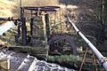
This old beam engine once pumped water from the Irwell to Mount Sion Mill.
-
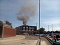
A fire at Radcliffe precinct on June 27, 2018.
-
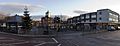
A view of Radcliffe's main shopping area.


See also
 In Spanish: Radcliffe para niños
