- This page was last modified on 17 October 2025, at 10:18. Suggest an edit.
Manchester Bolton & Bury Canal facts for kids
| Manchester Bolton & Bury Canal | |
|---|---|
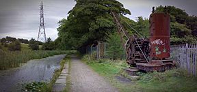
The Grade II Listed steam crane at Mount Sion, on the Bury arm
|
|
| Specifications | |
| Maximum boat length | 68 ft 0 in (20.73 m) |
| Maximum boat beam | 14 ft 2 in (4.32 m) (originally 7 ft 0 in or 2.13 m) (Widened from 1794) |
| Locks | 16 (originally 12 and later 17) (5 added for Irwell extension making 17 total, as of 2008 a single deep lock has replaced locks 1&2) |
| Original number of locks | 12 and later 17 |
| Maximum height above sea level | 247 ft (75 m) |
| Status | Under restoration |
| Navigation authority | Canal and River Trust |
| History | |
| Original owner | Manchester Bolton & Bury Canal Company |
| Principal engineer | Matthew Fletcher |
| Other engineer(s) | Hugh Henshall, Charles Roberts, John Nightingale |
| Date of act | 1791 |
| Date of first use | 1797 |
| Date completed | 1808 |
| Date closed | 1924, 1941, 1961 |
| Geography | |
| Start point | River Irwell, Salford (originally Oldfield Road, Salford) |
| End point | Bury and Bolton |
| Branch(es) | Fletcher's Canal |
The Manchester Bolton & Bury Canal is an old canal in Greater Manchester, England. It was built to connect the towns of Bolton and Bury with Manchester. When it was fully open, the canal was about 15 miles (24 km) long.
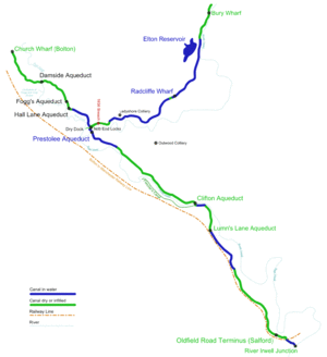
It started at the River Irwell in Salford. To climb to its highest point, the canal needed 17 locks. It went through Pendleton, then split into two parts: one going northwest to Bolton and the other northeast to Bury. The section between Bolton and Bury was flat, so it didn't need any locks. Six aqueducts were built to carry the canal over rivers like the Irwell and Tonge, and also over several roads.
Local landowners and business people started the canal project in 1791. It was built between 1791 and 1808, during a time known as the "Golden Age of canal building." It cost about £127,700, which would be a huge amount of money today. The canal was first planned for narrow boats, but its design was changed to fit wider boats. This was because they hoped to connect it to the Leeds and Liverpool Canal, though this connection never happened.
Later, the canal company also built a railway line next to the canal. This railway needed some changes to the Salford part of the canal. Most of the goods carried on the canal were coal from nearby mines. As the mines closed down, parts of the canal were used less and less. It was officially closed in 1961.
In 1987, a group was formed to try and bring the canal back to life for fun activities. In 2006, restoration work began near the River Irwell in Salford. Today, you can travel by boat on the canal as far as Oldfield Road in Salford.
Contents
History of the Canal
How the Idea Started
The area around the Irwell Valley had fast-flowing rivers that often flooded or dried up. This made it hard to move goods by river, except for the Mersey and Irwell Navigation west of Manchester. After the American Revolutionary War ended, things became more stable, and people started thinking about better transport.
In 1790, a plan for a canal linking Manchester, Bolton, and Bury was suggested. Matthew Fletcher, an engineer, had already surveyed the route. Meetings were held in Manchester and Bolton to discuss the idea. People wanted to ask Parliament for permission to build the canal.
Some local factories and mills were worried because they used water from the rivers and brooks. They feared the canal might take their water. So, a rule was added to the plan to protect mill owners. Another engineer, Hugh Henshall, promised that his plan would not take water from the river during dry times. He said floods and small streams would fill the canal's reservoirs.
Getting Money for the Canal
To build the canal, people bought shares in the company. A list of these early investors shows that many important people bought shares. The biggest investment was £3,000, and the smallest was £100. In total, £47,700 was raised this way.
The company made regular requests for more money from shareholders over the years. The canal started paying back its investors in July 1812, giving them a 4% profit.
Building the Canal
On May 13, 1791, Parliament approved the plan, and the company got permission to build the canal. They could buy land up to 26 yards (24 meters) wide for the canal. The plan was for the canal to split into two branches at Prestolee: one to Bolton and one to Bury.
A committee was formed to manage the building work. They ordered tools like wheelbarrows and planks. Matthew Fletcher was put in charge of buying land and talking to builders. In August 1791, a builder named John Seddon agreed to start work on a part of the canal.
The company also thought about extending the canal from Bury to connect with the Rochdale Canal. They even considered linking to the Leeds and Liverpool Canal. These connections would have brought a lot more boat traffic. However, the Bridgewater Canal owner, the Duke of Bridgewater, made a deal with the Rochdale Canal Company instead. So, in 1797, the Bury extension plan was dropped.
In 1794, an agreement was made to link the Bolton arm of the canal to the Leeds and Liverpool Canal. This meant the Manchester Bolton & Bury Canal had to be made wider to fit the bigger boats used on the Leeds and Liverpool Canal. This change cost a lot of money, but the Leeds and Liverpool Canal changed its route, so the link was never built. Even so, making the locks wider meant two narrowboats could use them at the same time, which saved time and water.
By 1796, much of the canal was finished, including the part to Bury. The Bolton arm opened the next year. In 1800, a connection to Fletcher's Canal was completed. But since the link to the Leeds and Liverpool Canal didn't happen, the canal was still separate from other waterways.
The company spent all its initial money and owed £31,345. In 1805, they got permission to raise another £80,000 to pay debts and finish the canal. By November 1808, the entire canal was complete. A connection to the Rochdale Canal finally happened in 1839 through the Manchester and Salford Junction Canal.
What the Canal Carried
Most of the boats on the canal carried coal from the many mines along its route. Some mines even had small railways to bring coal to the canal. In the late 1800s, over 650,000 tons of coal were moved each year. Other goods like salt and fruit were also transported. Milestones along the towpath helped calculate the fees, as many journeys were short.
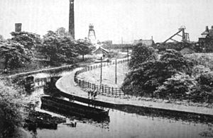
The coal boats were special. They had boxes with hinged bottoms. Cranes would lift these boxes out of the boats, position them over a storage area, and then open the bottom to drop the coal. This made loading and unloading very fast, helping the canal stay competitive.
In winter, the canal would sometimes freeze. An icebreaker boat called "Sarah Lansdale" was used to clear the ice. Horses pulled it while the crew rocked the boat to break the ice.
The canal also offered passenger services. A trip from Bolton to Manchester took about three hours. The first passenger boat launched in 1796. Passengers would often change boats at Prestolee to avoid delays at the locks. Over 60,000 people traveled on the canal each year in the 1830s. The service was quite comfortable, with heating in winter and drinks served on board.
The Railway Arrives
In 1830, the canal company decided to build a railway line next to the canal. In 1831, they got permission from Parliament to become the "Company of Proprietors of the Manchester, Bolton and Bury Canal Navigation and Railway Company." They planned to build a railway from Manchester to Bolton and Bury.
Local mine owners were worried they would lose access to the canal. So, the company agreed to keep the canal open and build the new railway alongside it. The railway opened on May 28, 1838. It carried far more passengers than the canal. Soon after, passenger services on the canal stopped, and the boats were sold.
Over the years, the railway company grew and changed names. In 1890, the railway line through Salford was widened. This meant some of the canal's locks had to be moved, and a bridge replaced a tunnel under the railway.
The Canal's Decline
By 1924, the Bolton arm of the canal was used much less. Coal trade continued until the 1930s, but then many mines closed, reducing traffic even more. Parts of the canal banks often burst, especially near the Irwell and Croal rivers, due to ground sinking from mining. A big break in the canal happened in 1936 and was never fixed.
In 1941, a law was passed that officially closed about 7 miles (11 km) of the canal, including a section from Prestolee to Clifton and the entire Bolton arm. During World War II, a section in Agecroft was put into pipes underground to protect a nearby factory from bomb damage.
The canal still made some money from selling water, but very little from tolls. By 1951, it was losing money. A report in 1955 said the canal no longer had enough business to stay open for boats. So, in 1961, the canal was officially closed. One last coal delivery service continued until 1968, but that was the end of commercial use.
Special Features of the Canal
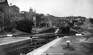
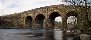
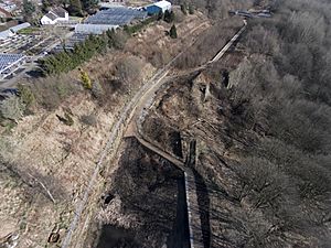
The canal has several interesting features. Prestolee Aqueduct and Clifton Aqueduct are both old, protected structures. Nob End Locks (also called Prestolee Locks) are where the three parts of the canal meet. They are made of two sets of three staircase locks, with a small area for boats to pass in between. These locks lowered the canal's level by 64 feet (19.5 meters) over a short distance. The upper part of the locks can still be seen, but most of the lower part was filled in during the 1950s.
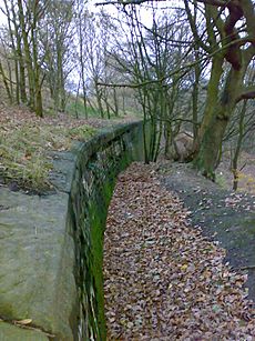
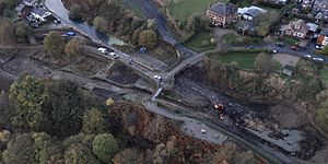
A large break in the Bury arm of the canal showed how strongly the walls were built. Old railway rails were used inside the walls to make them stronger. You can still see them where the canal broke.
The Mount Sion steam crane is a very old crane that sits rusting at Mount Sion, on the Bury arm. It was built around 1875–1884 and used to lift coal boxes from boats. It's now a protected historical item.
How the Canal Was Built
The canal originally got its water from the River Irwell in Bury. But this wasn't enough, so in 1842, Elton Reservoir was built to supply most of the canal's water. The Bury and Bolton arms of the canal were mostly flat. But the Salford arm used 17 wide locks to drop 190 feet (58 meters) over 8 miles (13 km) to its lowest point.
Even though the canal was first planned to be narrow, it was made wider in 1794. This was to allow for a connection with the Leeds and Liverpool Canal, which used wider boats. This meant some narrow locks that were already built had to be removed. The connection never happened, but the wider locks allowed two narrowboats to pass through at once, saving time and water.
Much of the Bury arm runs next to the River Irwell. Huge walls had to be built to stop the canal bank from sliding down the hill. Similar, but smaller, strengthening was needed on the Bolton arm where it ran beside the River Croal. In these areas, the towpath is usually on the side closest to the river.
Six aqueducts were needed to carry the canal over rivers and roads. On the Bolton arm, these included Hall Lane Aqueduct, Fogg's Aqueduct, and Damside Aqueduct, but these have all been taken down. On the Salford arm, the canal flowed over Prestolee Aqueduct, then Clifton Aqueduct, and finally Lumn's Lane Aqueduct (which is also gone).
Many bridges were also built along the canal. Most were small, for farm access, but larger bridges were built where the canal crossed important roads.
Cranes were used at the many wharfs (loading areas) along the canal to unload goods. The steam crane at Mount Sion is one example that still exists.
Canal Breaches
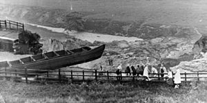
The canal has broken its banks many times. In 1799, a flood washed away parts of the banks. In 1853, two boats were swept away when a 93-yard (85-meter) section broke near Nob End Locks. More breaks happened in the late 1800s due to the ground sinking from mining. Engineers worked to fix these problems. The canal company even bought land with coal under the canal to prevent future sinking.
One of the most serious breaks happened on July 6, 1936, near Nob End. The Manchester Evening News reported it the next day:
CANAL BURSTS ITS BANKS - Barges Smashed and River Dammed "When the Bolton-Manchester Canal burst its banks at Little Lever yesterday millions of gallons of water cascaded 300 feet into the River Irwell, carrying down hundreds of tons of earth and stones. The river rapidly became blocked on the Bury side and the banked-up water flooded the surrounding land. "Like Niagara" was the description applied by one resident in the vicinity. Bricks and iron reinforcements of the side of the canal were torn away and carried into the river. Canal barges were smashed up as they too swept over the falls. Fortunately, there are no houses in the neighbourhood, and no one was hurt. It is feared that work at a paper mill and a chemical works which depend upon the canal for transport will be affected. Mr John W. Martin, of Loxham Street, Bolton, said: "I was cycling along the bank when I suddenly saw signs of a subsidence begin on a bend in the canal. I could not stop and my only chance was to ride furiously along the two feet of earth which remained. As I passed over the earth fell away behind the back wheel of my bicycle and I was thrown off. "The noise was deafening. A few yards from me tremendous quantities of water, rock, and earth were moving bodily from the canal. A gap about 100 yards long has been opened in the canal embankment. A few years ago there was a similar landslide near the spot."
This 1936 break was never repaired. Although the canal was still used for a while, it eventually closed in 1961.
What the Canal Looks Like Today
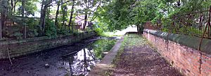
Almost 60% of the canal's original length no longer holds water. Bury Wharf is now an industrial area. A car park covers part of the canal near Daisyfield Viaduct. The canal is still in water but overgrown with weeds near Radcliffe. It continues in water up to a dam at Ladyshore.
The 1936 break was never fixed, leaving a big gap in the canal's path. On the Salford arm, the top three locks at Prestolee are ruined, and the bottom three are gone. The canal has water from the bottom of the locks to Ringley Locks. Ringley Bridge is filled in, as is the canal through Ringley Village. Kilcoby Bridge is missing.
The canal is blocked by the M60 motorway, which was built over its path. A sludge pond also blocks a section near Clifton Aqueduct. The canal gets water again beyond Clifton Aqueduct for a short section. Lumn's Lane Aqueduct is gone, but the canal has water between there and Holland Street. Beyond that, the canal is filled in and built over, especially through Pendleton. The part where it met the River Irwell in Salford has recently been fixed and can be used by boats again.
On the Bolton arm, Hall Lane Aqueduct was taken down in 1950, leaving a gap. Damside Aqueduct in Darcy Lever was also removed in 1965. The St Peter's Way road has destroyed a large part of the canal going into Bolton. The last part of the Bolton arm that still has water is now used for fishing.
The entire route of the canal is protected. This means that new buildings or projects cannot stop its future restoration.
Bringing the Canal Back to Life
To help save the canal, the Manchester Bolton & Bury Canal Society was started in 1987. They work to protect the canal and get it restored. In 2005, money was announced for a restoration project at Middlewood Locks in Salford. This work started in September 2006.
During the restoration, workers found what they thought was a World War II bomb, but it was just an old mortar with no explosives. A new tunnel was built under the Manchester to Preston Line. The old Bloody Bridge, which was missing, was replaced with a new wooden bridge. Much of the canal's old stone was reused. The first two river locks were replaced by a single, deeper lock.
The restoration of this section was finished in July 2008, and an opening ceremony was held in September. A new tunnel under the Manchester Inner Ring Road was named the Margaret Fletcher tunnel. Bringing the whole canal back to life could create up to 6,000 jobs and add £6 million to the local economy each year. The total cost is estimated to be £60 million. The next big restoration project might be along Salford Crescent.
Local volunteers from the Manchester Bolton and Bury Canal Society have been working for years to clear overgrown plants and tidy up the canal. In April 2013, a new pedestrian bridge was opened at Nob End Locks. It was designed by artist Liam Curtin and built by volunteers using large pieces of Meccano. Toward the end of 2015, work began to dig out the buried locks at Nob End, showing the six locks again. They also dug out the infill under the first bridge on the Bolton arm, revealing the towpath that had been hidden for decades.
Locations of Canal Features
|
|
|
| Coordinates |
|---|

