Clifton, Greater Manchester facts for kids
Quick facts for kids Clifton |
|
|---|---|
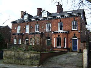
 Housing on Rake Lane near the railway station |
|
| OS grid reference | SD775035 |
| Metropolitan borough | |
| Metropolitan county | |
| Region | |
| Country | England |
| Sovereign state | United Kingdom |
| Post town | MANCHESTER |
| Postcode district | M27 |
| Dialling code | 0161 |
| Police | Greater Manchester |
| Fire | Greater Manchester |
| Ambulance | North West |
| EU Parliament | North West England |
| UK Parliament |
|
Clifton is a neighbourhood in Swinton, which is part of the City of Salford in Greater Manchester, England. It sits on the edge of the Irwell Valley in the northern part of Salford. Long ago, Clifton was part of Lancashire. It was a very important place for coal mining.
Contents
Clifton's Past: A Look at History
The name Clifton comes from old English words. Clif means "cliff" or "slope," and tun means "settlement." So, Clifton means "the settlement near a cliff or riverbank." Clifton was first mentioned in official records way back in 1183 or 1184.
Mining for Coal in Clifton
Clifton was once a busy centre for coal mining. One important mine was Clifton Hall Colliery. It started operating around 1820. This mine closed in 1929.
A very sad event happened at Clifton Hall Colliery on June 18, 1885. An explosion deep underground killed 178 men and boys. Investigations showed that the explosion was caused by firedamp (a dangerous gas) catching fire from a candle.
After the explosion, brave people went into the mine to help. Two of them, 16-year-old blacksmith George Hindley and fireman George Higson, were given an Albert Medal for their heroic actions.
Another mine, Wet Earth Colliery, closed in 1928. You can still see parts of it today in Clifton Country Park. This park is close to the River Irwell and the Manchester-Preston railway line.
Clifton's Industries and Factories
Besides coal mining, Clifton also had other important industries. Pilkington's Lancastrian Pottery started making beautiful pottery and tiles in 1892. The Chloride Electrical Storage Company opened a factory here in 1893 to make batteries. Later, in 1936, Magnesium Elektron Ltd built a large factory to produce magnesium metal.
How Clifton Was Governed
Clifton used to be a small area called a "township" within the larger area of Eccles. In 1933, the township was divided up. Parts of it became part of Kearsley Urban District and the Municipal Borough of Swinton and Pendlebury.
Clifton's Location and Landscape
Clifton is located about five miles northwest of Manchester. The main road through it is the A666 road, which goes to Bolton. The area covers about 850 acres. The River Irwell forms its northeastern border.
The Manchester-Preston railway line runs through Clifton. There was once a railway junction here for a line that went to Bury and Rossendale. The land in the west of Clifton is higher, reaching over 300 feet above sea level. This area is mostly moss land.
Getting Around: Transport in Clifton
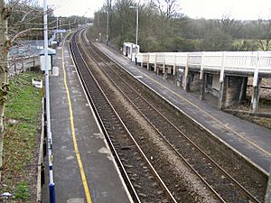
Clifton has its own train station, Clifton railway station, which is on the Ribble Valley Line. In the past, this station was called "Clifton Junction." This was because it was where the Manchester and Bolton Railway met the Manchester, Bury and Rossendale Railway lines.
The line to Bury crossed the Irwell Valley over the Clifton Viaduct. This viaduct is famous locally as "the thirteen arches." Clifton Junction was very important for bringing workers to the large factories nearby, like Magnesium Elektron, Chloride Batteries, and Pilkington's Tiles.
The Manchester, Bolton and Bury Canal also passed through Clifton. The Clifton Aqueduct carried the canal over the River Irwell. This aqueduct is now a listed building and is protected. There are plans to fix up the canal for people to use for fun activities.
Clifton's Churches
Clifton has two Anglican churches. St. Anne's Church has been on Manchester Road since it was finished in 1874. St. Thomas's Church was built in 1974. It replaced an older church from 1898 that was made of corrugated metal. People used to call the old church "Th'owd Tin Mission."
Learning in Clifton: Schools
Clifton has two primary schools and a special centre for students who need extra support.
| School | Locality | Description | Ofsted |
|---|---|---|---|
| Clifton Primary School | Wroe Street, Clifton, M27 6PF | Primary school | 105907 |
| St Mark's R.C. Primary School | Queensway, Clifton, M27 8QE | Primary school | 105956 |
| The Clifton Centre | Silverdale, Clifton, M27 8GW | Pupil referral unit | 130007 |
Clifton Library
You can find Clifton Library at the Clifton Community Centre on Wynne Avenue.
Sports and Recreation
Clifton Cricket Club plays in the Premier Division of the Greater Manchester Cricket League. The club has been very successful recently. They have won the GMCLT20 competition three times and become regional T20 champions. They also reached the finals of national cricket competitions. Their cricket ground is on Manchester Road.
Queensmere Dam is a local spot for fishing. It is leased by Swinton and Pendlebury Anglers. Queensway, a road built in the 1960s, links many parts of Clifton to Bolton Road. Before this road, Queensmere Dam was just known as "the Dam."
Local Meeting Spots: Public Houses
Clifton has three public houses, or pubs, along Manchester Road: the Oddfellows Arms, the Golden Lion, and the Robin Hood. The Holyrood nursery on Rake Lane used to be a pub called the Beehive.
Clifton Barracks
The British Army has a training centre on Manchester Road. It's known locally as "Clifton Barracks." This centre is very close to junction 16 of the M60 motorway.
 | Charles R. Drew |
 | Benjamin Banneker |
 | Jane C. Wright |
 | Roger Arliner Young |


