Whitefield, Greater Manchester facts for kids
Quick facts for kids Whitefield |
|
|---|---|
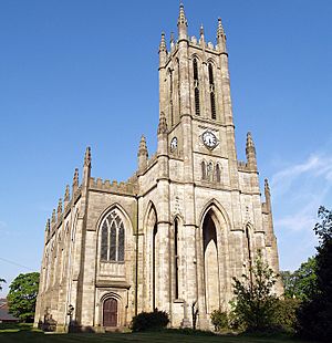
 All Saints' Church, Stand, a Waterloo church in Whitefield |
|
| Population | 23,283 (2001 Census) |
| OS grid reference | SD815065 |
| • London | 168 mi (270 km) SE |
| Metropolitan borough | |
| Metropolitan county | |
| Region | |
| Country | England |
| Sovereign state | United Kingdom |
| Post town | MANCHESTER |
| Postcode district | M45 |
| Dialling code | 0161 |
| Police | Greater Manchester |
| Fire | Greater Manchester |
| Ambulance | North West |
| EU Parliament | North West England |
| UK Parliament |
|
Whitefield is a town in Greater Manchester, England. It is part of the Metropolitan Borough of Bury. The town is located on hilly ground near the River Irwell. It is about 3 miles (4.8 km) southeast of Bury. Whitefield is also about 5 miles (8.0 km) northwest of Manchester. In 2001, about 23,283 people lived there.
Whitefield was historically part of Lancashire. An old Roman road passed through the area. This road connected Mamucium (Manchester) to Bremetennacum (Ribchester). For many centuries, Whitefield was a part of the Pilkington area. This area was known for farming. People also wove wool at home to earn extra money.
Whitefield grew a lot during the Industrial Revolution. The town's name might come from "bleachfields." These were areas where Flemish settlers whitened their fabrics. Another idea is that the name comes from "wheat-fields." New roads helped Whitefield grow into a mill town by the mid-1800s. It became a local government district in 1866.
Contents
- What's in a Name? The History of Whitefield's Name
- Whitefield's Early History
- How Whitefield is Governed
- Whitefield's Location and Surroundings
- Who Lives in Whitefield? Demographics
- Whitefield's Economy and Jobs
- Getting Around Whitefield: Transport
- Places of Worship in Whitefield
- Culture, Education, and Sports in Whitefield
- Public Services in Whitefield
- Places to Visit in Whitefield
- See also
What's in a Name? The History of Whitefield's Name
There are a few ideas about how Whitefield got its name. One idea is from John Wilson's book, A History of Whitefield (1979). It suggests the name came from Flemish weavers. They used to spread out their fabrics to bleach them in the sun. This process was called "tentering."
Another idea is that Whitefield was once a farming area with open fields. So, the name might be a changed version of "Wheat-fields." A third idea is that the name refers to a field of white flowers. There is even a street called Lily Hill Street, which supports this idea.
An old document from 1861 mentions "Whitefield Moore" in Pilkington. This shows the name has been around for a long time.
Whitefield's Early History
In the time of Queen Elizabeth I, Whitefield was mostly open moorland. Until the 1800s, it was part of the Manor of Pilkington. In the 1400s, the Pilkington family owned much of the land. They supported the House of York during the Wars of the Roses.
After Richard III was defeated in 1485, Henry VII became king. He rewarded Thomas Stanley by making him the Earl of Derby. The Earls of Derby then received many lands, including Pilkington and Bury. They usually had agents manage their lands. This was different from the Earls of Wilton, who lived nearby and helped their local communities.
Over many years, small villages grew in the Whitefield area. These included Besses o' th' Barn, Lily Hill, and Stand. These small places eventually formed what we know as Whitefield today.
How Whitefield is Governed
In 1853, Whitefield was part of the Pilkington area. In 1894, Pilkington stopped being a separate area. Part of Whitefield's border also changed to include parts of Radcliffe. This change helped with the sewage system in the area.
Whitefield got its own local board in 1866. After 1894, it became an urban district. This meant it had its own local government.
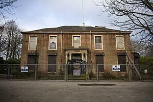
The Whitefield Town Hall was bought in 1933. It used to be a house called Underley. Before that, the council meetings were held on Elms Street. On April 1, 1974, Whitefield became part of the Metropolitan Borough of Bury. This is a local government area within Greater Manchester.
Whitefield's Location and Surroundings
 |
Radcliffe | Bury | Heywood |  |
| Kearsley | Middleton | |||
| Clifton | Prestwich | Heaton Park |
Whitefield is located at 53°33′7″N 2°17′57″W / 53.55194°N 2.29917°W. It is west of where the M60 and M66 motorways meet. The River Irwell is to the south. Larger towns like Bury and Middleton are to the north and east. Whitefield is considered part of the Greater Manchester Urban Area. Manchester city centre is about 5 miles (8.0 km) south-southeast of Whitefield.
Smaller areas within Whitefield include Besses o' th' Barn, Hillock, and Stand. Kirkhams is south of the M60 motorway.
Whitefield has three medium-sized council housing estates: Hillock Estate, Elms Estate, and Victoria Estate. The Elms estate was built from the 1920s to the 1950s. The Hillock estate was planned in the 1950s. It was for 8,000 people moving from crowded parts of Manchester. Many of these homes are now privately owned.
Much of Whitefield is made up of middle-class suburban areas. These are homes for people who travel to work in other towns. There are also some older terraced houses, especially near Lily Hill Street. The area also has larger homes around Ringley Road and Park Lane. New buildings have been added in recent years.
Who Lives in Whitefield? Demographics
| Whitefield compared | |||
|---|---|---|---|
| 2001 UK census | Whitefield | Bury (borough) | England |
| Total population | 23,283 | 180,608 | 49,138,831 |
| White | 95.3% | 93.9% | 90.9% |
| Asian | 2.0% | 4.0% | 4.6% |
| Black | 0.7% | 0.5% | 2.3% |
In 2001, a census counted the population of the UK. It gathered details like age, ethnicity, and religion. The census showed Whitefield had 23,283 people. There were more females than males.
About 28.8% of people over 16 were single. 44.6% were married, and 8.4% were divorced. Whitefield had 9,849 households. Many were one-person homes (29.8%) or married couples (36.8%). About 11.4% were single parents. Also, 30.2% of people aged 16–74 did not have formal academic qualifications.
In terms of religion, most residents (74.3%) were Christian. 6.0% were Jewish, and 1.6% were Muslim. About 10.3% said they had no religion.
How Whitefield's Population Has Changed
Historians have tracked Whitefield's population over time. In 1666, there were 135 "hearths" (homes). By 1714, the population was about 740. It grew to 2,455 in 1789 and 2,780 in 1793.
The table below shows how the population has grown since 1901:
| Population growth in Whitefield since 1901 | |||||||||||
|---|---|---|---|---|---|---|---|---|---|---|---|
| Year | 1901 | 1911 | 1921 | 1931 | 1939 | 1951 | 1961 | 1971 | 1981 | 1991 | 2001 |
| Population | 6,588 | 6,976 | 6,902 | 9,107 | 12,192 | 12,914 | 14,372 | 21,866 | 27,650 | 22,783 | 23,284 |
| Urban District 1901–1971 • Urban Subdivision 1981–2001 | |||||||||||
Whitefield's Economy and Jobs
| Whitefield compared | |||
|---|---|---|---|
| 2001 UK Census | Whitefield | Bury (borough) | England |
| Population of working age | 16,824 | 151,445 | 35,532,091 |
| Full-time employment | 42.2% | 42.9% | 40.8% |
| Part-time employment | 11.7% | 12.0% | 11.8% |
| Self-employed | 7.5% | 8.1% | 8.3% |
| Unemployed | 2.7% | 2.8% | 3.3% |
| Retired | 15.1% | 13.3% | 13.5% |
In the early 1900s, Whitefield had many businesses related to textiles. These included companies that bleached, dyed, and finished fabrics. There were also cotton manufacturers and companies making small fabric items. Building companies were also present.
Whitefield is close to the M60 motorway and Manchester city. This means many small businesses and trading areas are located here. In recent years, Whitefield has seen new shops and businesses built. For example, a new Morrisons supermarket opened in 2008.
A sweet factory, Hall's, used to be on Stanley Road. They were famous for their "Mentho-Lyptus" cough drops. A large flooring company, Polyflor, is still in the area.
The 2001 census showed what kinds of jobs people in Whitefield had. Many worked in retail and wholesale (18.9%). Others worked in manufacturing (13.7%), health and social work (12.2%), and business services (11.9%). Whitefield had more people working in finance compared to the national average.
Getting Around Whitefield: Transport

Public transport started in Whitefield in the early 1800s. By 1817, coach services ran between Manchester and Bury. These coaches likely carried goods more than people. The Coach & Horses public house at Kirkhams was a stop for these coaches.
A new road, Bury New Road, was built in 1827. It was a "turnpike road," meaning people paid a toll to use it. Toll booths were set up along this road.
In the 1860s and 1870s, a four-horse bus ran hourly between Whitefield and Manchester. Local stops included the Bay Horse Inn and the Church Inn.
Steam trams started running in 1883 between Bury and Kersal Bar. Later, electric trams replaced them. These trams connected Bury and Manchester. In 1926, buses replaced the trams between Whitefield and Manchester. A bus station opened in 1931.
Interestingly, in the 1920s, evening trams had letterboxes on the front. This allowed people to post letters at tram stops. The letters would reach the Manchester post office in time for the last collection.
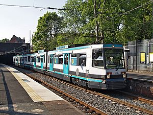
On July 18, 1872, a railway line was approved. It connected Manchester and Bury, passing through Whitefield. The Lancashire and Yorkshire Railway line opened in 1879. A new station, Whitefield railway station, was built. The line became electric in 1916. This cut travel time between Manchester and Bury from 32 minutes to 24 minutes.
Today, this line is used by the Metrolink. Services started on April 6, 1992. Another station, Besses o' th' Barn, also serves the area. All public transport in the area is managed by Transport for Greater Manchester.
Places of Worship in Whitefield
In the 1600s, a law called the Five Mile Act 1665 made it hard for non-Church of England groups to meet. Stand, near Whitefield, was a good place for them to gather. It was far enough from major towns to be legal. People started meeting at Old Hall, the home of Thomas Sergeant.
By 1672, a barn was used for preaching. In 1693, the Rev. Robert Easton became the first Minister of Stand Chapel. This building also served as Stand Grammar School during weekdays.
Over time, Stand Chapel became Unitarian. This caused some people to leave and form a new church, Stand Independent Chapel. The original Stand Unitarian Chapel was rebuilt in 1818.
Stand All Saints' CofE Church is a famous landmark. It was built to celebrate Napoleon's defeat at the Battle of Waterloo in 1815. The Earl of Derby gave the land for the church. It was designed by Sir Charles Barry in a Gothic style. The church tower is 186 feet (57 m) tall. It cost £14,987 to build. The church is now part of a special conservation area.
By 1952, there were enough Roman Catholics in Whitefield to need their own church. St Bernadette's Church was built on Manchester Road in 1956.
Next to St Bernadette's, a meetinghouse for the Church of Jesus Christ of Latter-day Saints was built.
Other places of worship include the New Jerusalem Church, Whitefield Methodist Chapel, and Besses United Reformed Church. There are also two synagogues and a spiritualist church.
Whitefield Hebrew Congregation built its synagogue on land that used to be a Church of England school.
In 2010, plans were made for an eruv in Whitefield. An eruv is a symbolic boundary that allows Orthodox Jewish families to do things normally not allowed on the shabbat (Sabbath). This includes carrying keys or pushing prams. The Whitefield eruv would be the first outside London in the UK.
Culture, Education, and Sports in Whitefield
Whitefield has local newspapers like the Advertiser and the Prestwich and Whitefield Guide.
Sedgley Park R.U.F.C. is a rugby team that plays its home matches at Park Lane.
The Besses o' th' Barn Band has been around since at least 1818. It started as a string band and then became a reed band. It was founded by three brothers, John, James, and Joseph Clegg. The band's headquarters have been on Moss Lane since 1884. In the early 1900s, this brass band became very famous. They even went on world tours!
Stand Cricket Club, founded in 1853, plays on Hamilton Road.
Whitefield is the birthplace of Dodie Smith. She is the author of the famous novel The Hundred and One Dalmatians.
Public Services in Whitefield
Whitefield's gas supply was first provided by the Radcliffe and Pilkington Gas Company, founded in 1864.
Around 1883, Thomas Thorp started an engineering business in Victoria Lane. He had an observatory on his roof. He also invented the "penny-in-the-slot" gas meter. This allowed people to pay for gas as they used it.
Places to Visit in Whitefield
- The Nature Trail
- Red Rose Forest – This is the second largest community forest in England.
- Irwell Sculpture Trail
See also
 In Spanish: Whitefield para niños
 | Selma Burke |
 | Pauline Powell Burns |
 | Frederick J. Brown |
 | Robert Blackburn |


