Heywood, Greater Manchester facts for kids
Quick facts for kids Heywood |
|
|---|---|
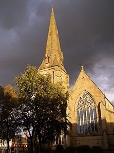
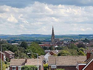 A view of Heywood, towards St Luke's Church |
|
| Area | 7 sq mi (18 km2) |
| Population | 28,205 (2011) |
| • Density | 4,029/sq mi (1,556/km2) |
| OS grid reference | SD855104 |
| • London | 169 mi (272 km)SSE |
| Metropolitan borough |
|
| Metropolitan county | |
| Region | |
| Country | England |
| Sovereign state | United Kingdom |
| Post town | HEYWOOD |
| Postcode district | OL10 |
| Dialling code | 01706 |
| Police | Greater Manchester |
| Fire | Greater Manchester |
| Ambulance | North West |
| EU Parliament | North West England |
| UK Parliament |
|
Heywood is a town in Greater Manchester, England. It's part of the Metropolitan Borough of Rochdale. In 2011, about 28,205 people lived there. Heywood is located on the south side of the River Roch. It's about 2 miles (3.2 km) east of Bury, 4 miles (6.4 km) southwest of Rochdale, and 8 miles (12.8 km) north of Manchester. To the south is Middleton, and to the north are hills and open land called the Pennines.
Long ago, the Anglo-Saxons cleared the thick forests here, making fenced areas called "heys." In the Middle Ages, Heywood was a small church area around Heywood Hall, a large house owned by the Heywood family. Most people were farmers, but they also wove wool at home to earn extra money.
Later, in the late 1700s, factories started to appear. Heywood grew into a "mill town" because of its many cotton mills and coal mining areas. During the mid-1800s, the cotton business grew so fast that many new people moved to Heywood. The town became an official borough in 1881. In the mid-1900s, the cotton and mining industries slowed down. Heywood was known for its high-quality cotton. The Queen Mother even visited in the early 1900s to see the cotton factories. Cotton from Heywood was used to make a dress she wore for her 50th birthday!
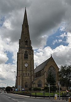
Heywood is close to a major highway, the M62 motorway, which helps transport goods from the large distribution parks in the town's south. The tall, 188-foot (57 m) Parish Church of St Luke the Evangelist, built in the 1860s, stands out in the town centre. Heywood was also the birthplace of Peter Heywood, a judge who helped discover the famous Gunpowder Plot in 1605. Today, Heywood has a station on the East Lancashire Railway, a special heritage railway.
Contents
- Heywood's Past: A Look at History
- How Heywood is Governed
- Heywood's Location and Surroundings
- Heywood's People: Demographics
- Heywood's Economy: How People Work
- Heywood's Landmarks: Places to See
- Getting Around: Transport in Heywood
- Learning in Heywood: Education
- Sports and Activities in Heywood
- Famous People from Heywood
- Twin City
- See also
Heywood's Past: A Look at History
Early Times and the Heywood Family
People have lived in the Heywood area for a very long time, even back to the Mesolithic period (the Middle Stone Age). Old tools made of flint have been found here. Things from the Roman period and the Bronze Age have also been discovered. For example, a Bronze Age burial mound about 2 feet (0.6 m) high and 33 feet (10 m) wide was found in the 1960s.
The name Heywood likely comes from an old English word, "haga," which means a hedge or an animal enclosure. In the 1100s, Heywood was a small village within a larger area called Heap. The Heywood family, who lived in Heywood Hall, were important people in the area from the 1000s onwards. One famous member, Peter Heywood, was a judge who helped arrest Guy Fawkes during the Gunpowder Plot in 1605. Another Peter Heywood was on the ship HMS Bounty when its crew rebelled in 1789.
From Farming to Factories: The Industrial Revolution
For many years, Heywood was a quiet farming area with only a few small villages. Farmers often made extra money by weaving wool and other fabrics at home using spinning wheels. But as the demand for cotton grew and new machines were invented in the 1700s, bigger buildings were needed.
The first cotton mill in Heywood, Makin Mill, was built in the late 1700s. Soon, people started leaving farming to work in these new factories. The cotton business in Heywood boomed, and by 1833, there were 27 cotton mills! This huge growth meant many new people moved to Heywood, making it a very busy place. By 1885, a poet named Edwin Waugh said Heywood was "almost entirely the creation of the cotton industry."
Heywood also had coal mining. Coal pits were opened in the early 1800s. Some mines, like Captain Fold Colliery, had accidents and closed. Mining continued in some areas until 1950.
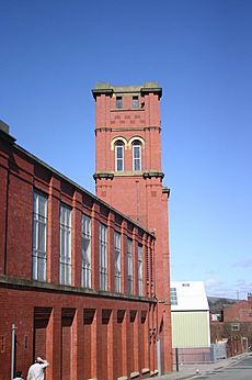
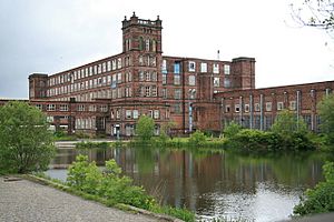
In 1905, Plum Tickle Mill opened as the world's largest cotton spinning mill under one roof. However, like many other mills, it closed in the 1960s. Most of Heywood's old cotton mills have now been taken down to make way for new homes. Some, like the Mutual Mills, are still standing and are protected as historic buildings.
Modern Heywood: Changes and Growth
In the 1970s, the railway line that served Heywood closed. But it has since been reopened as part of the East Lancashire Railway heritage project, connecting Heywood to Bury.
There's a local story that people from Heywood used to have tails, and pubs even had holes in their benches for them! This led to Heywood being nicknamed "Monkey Town." A more likely reason for the nickname is that the town was once called "Heap Bridge," which sounded like "Ape Bridge" to Irish workers building the railway.
In the 1900s, Heywood's cotton mills faced tough times. Many closed down. In 2007, plans were made to update Heywood and make it more appealing to younger people. This plan includes building new shops, businesses, and homes.
A local legend says that the southern part of St Luke's Church was so beautiful that Adolf Hitler wanted to take it if he had won World War II.
How Heywood is Governed
Local Government History
Heywood has been part of Lancashire since the 1100s. The Heywood family, who lived at Heywood Hall, had a lot of power in the area for centuries.
In 1864, Heywood got its first local health board to help with hygiene and sanitation. This board grew, and in 1881, Heywood officially became a Municipal Borough. This meant it had its own local council. The council worked from Heywood's Municipal Buildings. Over the years, Heywood's boundaries changed a bit, adding some areas and giving away others. In 1967, Heywood became a "twin town" with Peine in Germany, meaning they have a special friendship.
In 1974, the Municipal Borough of Heywood was dissolved. Heywood then became part of the Metropolitan Borough of Rochdale in Greater Manchester. The old Municipal Buildings were taken down in the mid-1980s. Today, Heywood has its own "Township Committee" within Rochdale, which meets regularly to discuss local issues and help make Heywood a better place.
Who Represents Heywood in Parliament?
For a long time, Heywood was part of different areas that elected Members of Parliament (MPs) to the House of Commons in London. Since 1983, Heywood has been part of the Heywood and Middleton constituency. From 2014 to 2019, the MP was Liz McInnes from the Labour Party. In the 2019 election, Chris Clarkson from the Conservative Party became the MP.
Heywood's Location and Surroundings
Heywood is about 169 miles (272 km) north-northwest of central London. It sits south of the Pennines hills, on the south bank of the River Roch. Bury, Middleton, and Rochdale are nearby towns. Heywood is about 7.4 miles (11.9 km) south of Manchester city centre.
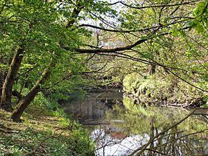
The River Roch flows west of Heywood towards Bury, then joins the River Irwell. The land in Heywood generally gets higher as you move away from the river. To the north are the Roch Valley and Cheesden Valley, which has a wooded river and high moorland. The soil in Heywood is sandy, with clay underneath.
Heywood's main area has homes around Market Street, which is the town's business centre. There are different types of housing, from busy urban areas to quiet rural spots. Most of the land is used for homes. Heywood is surrounded by a "Green Belt," which includes wooded valleys, moorland in the north, and flat farmland in the south.
Some areas within Heywood include Broadfield, Captain Fold, Crimble, Darnhill, and Hopwood. Darnhill is a planned housing area built in the 1950s and 1960s. Thousands of people moved there from crowded areas in Manchester, increasing Heywood's population.
 |
Ramsbottom | Norden | Whitworth |  |
| Bury | Rochdale | |||
| Whitefield | Middleton | Royton |
Heywood's People: Demographics
| Heywood Compared | |||
|---|---|---|---|
| 2011 UK Census | Heywood | Rochdale (borough) | England |
| Total population | 28,205 | 211,699 | 53,012,456 |
| White | 95.6% | 81.7% | 85.4% |
| Asian | 2.0% | 14.9% | 7.8% |
| Black | 1.0% | 1.3% | 3.5% |
In 2001, Heywood had a population of 28,024. There were slightly more females than males. About 30.3% of people over 16 had never been married, and 39.7% were married. Most households were either one-person homes or married couples. About 38.3% of people aged 16–74 did not have any formal qualifications.
In 2001, most Heywood residents (80.6%) said they were Christian. A smaller number were Muslim (1.1%) or followed other religions. About 9.9% said they had no religion.
Heywood's population stayed fairly steady for most of the 1900s. But it grew from 24,090 in 1960 to 30,443 in 1970. This was because of the Darnhill housing estate, which brought thousands of people from inner-city Manchester to Heywood starting in 1963.
| Population change in Heywood since 1891 | |||||||||||||||
|---|---|---|---|---|---|---|---|---|---|---|---|---|---|---|---|
| Year | 1891 | 1901 | 1911 | 1921 | 1931 | 1939 | 1951 | 1961 | 1971 | 1981 | 1991 | 2001 | |||
| Population | 23,185 | 25,458 | 26,697 | 26,693 | 25,968 | 25,063 | 25,201 | 24,090 | 30,443 | 29,686 | 29,286 | 28,024 | |||
|
Urban Sanitary District 1891 Municipal Borough 1901–1971 Urban Subdivision 1981–2001 |
|||||||||||||||
Heywood's Economy: How People Work
| Heywood Compared | |||
|---|---|---|---|
| 2011 UK Census | Heywood | Rochdale | England |
| Population of working age | 20,754 | 152,742 | 38,881,374 |
| Full-time employment | 39.7% | 36.4% | 38.6% |
| Part-time employment | 15.1% | 13.2% | 13.7% |
| Self employed | 6.9% | 7.0% | 9.8% |
| Unemployed | 6.6% | 5.9% | 4.4% |
| Retired | 14.1% | 13.7% | 13.7% |
For a long time, Heywood's economy was all about making textiles, especially cotton. But since the factories closed down in the 1900s, Heywood's economy now focuses on its town centre and the Heywood Distribution Park. This park is one of the biggest industrial parks owned by a single company in the UK. It covers over 200 acres (81 ha) and is home to large companies like Argos and Eddie Stobart.
The whole town is being improved as part of a big government plan called "New Deal for Communities." This plan is investing about £52 million to make Heywood better. Some projects have included a new health centre, a new family centre, and a sports and leisure village.
In 2001, most people in Heywood worked in retail (shops) and wholesale (selling goods in bulk), manufacturing (making things), and health and social work. A smaller number worked in education, transport, and construction.
The Heywood Advertiser is a local newspaper that started in the 1800s. It has a readership of 16,500 people and also has a website.
Heywood's Landmarks: Places to See
Heywood's most important landmark is the parish church of St Luke the Evangelist. It's the main building in the town centre. There was a church here even before 1611. The current church was built in the 1860s. Its tall tower and spire are separate from the main church building and stand 188 feet (57 m) high, making it a clear landmark in Heywood.
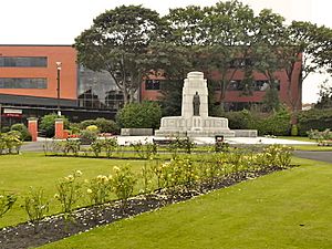
The Heywood War Memorial is in Memorial Gardens, across from St Luke's Church. It was built to remember the men from Heywood who died in the First World War and later, the Second World War. It's a grey stone monument with a bronze statue of a woman holding a laurel wreath, which means peace. The names of the fallen soldiers were finally carved onto the memorial in 1986, after a long campaign.
Ashworth Valley is a beautiful local area. Queens Park was reopened in 2006 after a big renovation, bringing back many of its old Victorian features like the fountain and statues.
Getting Around: Transport in Heywood
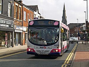
Public transport in Heywood is managed by Transport for Greater Manchester. Buses connect Heywood to places like Bolton, Bury, Rochdale, and Manchester. Major roads also link Heywood to other towns. The M62 motorway passes south of the town, and you can get on it at Junction 19.
Heywood also has a railway station on the East Lancashire Railway. This is a special heritage railway that connects Heywood to Rawtenstall railway station and Ramsbottom railway station. The original station closed in 1970, but it reopened in 2003 as an extension of the heritage railway from Bury Bolton Street railway station.
Learning in Heywood: Education
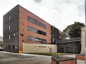
Heywood Technical School opened in 1894. It also had an art school. Later, it became Heywood Day Secondary School and then Heywood Grammar School. In 2010, Heywood Community High School closed, even though it was a very good school.
Here are some of the schools in Heywood:
- Hopwood County Primary School
- St. Luke's C.E. Primary School
- All Souls' Primary School
- St. Joseph's R.C. Primary School
- Harwood Park Primary School
- Heapbridge Primary School
- Woodland Primary School
- St. Margaret's Primary School
- Our Lady and St Paul's R.C. Primary School
- Newhouse Academy
- Holy Family RC & CE College (formerly St. Joseph's R.C. High School)
Birtle View was a school for children with special needs. It closed in 2007, and the building was replaced by a doctor's surgery.
Sports and Activities in Heywood
Heywood Cricket Club plays in the Central Lancashire Cricket League. They have won the Wood Cup nine times since 1921.
Heywood Hockey Club is a men's field hockey club in Heywood.
Darnhill and Heywood Amateur Boxing Club is located in Darnhill.
The Heywood Sports Culture and Leisure Village was built to offer new sports and leisure activities.
Famous People from Heywood
Many notable people were born or grew up in Heywood:
- Lewis Alessandra: A professional footballer.
- William Brett: A former trade union leader.
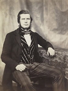
- Roger Fenton: A very early war photographer, born in Heywood in 1819.
- Christine Gaskell: A gold medalist swimmer from the 1974 British Commonwealth Games. The local swimming pool, Gaskell Pool, is named after her.
- Paul Gerrard: A professional goalkeeper who played for Oldham Athletic and Sheffield United.
- Julie Goodyear: An actress famous for playing Bet Lynch in Coronation Street.
- Peter Kane: World flyweight boxing champion in 1938–39.
- David Malin: A famous astrophotographer.
- Nico Mirallegro: An actor known for My Mad Fat Diary.
- Keri-Anne Payne: A British Olympic swimmer and silver medalist, who has lived in Heywood since she was 13.
- Debbie Rush: An actress who plays Anna Windass in Coronation Street.
- Ian Simpson: A well-known architect.
- Anne Kirkbride: The late actress famous for playing Deirdre Barlow in Coronation Street lived in Heywood for many years.
- Lisa Stansfield: An R&B and soul singer.
- Elliott and Luke Tittensor: Actors.
- Ryan Tunnicliffe: A professional footballer who started at Manchester United.
Twin City
Heywood is twinned with Peine in Germany.
See also
 In Spanish: Heywood (Gran Mánchester) para niños
 | Georgia Louise Harris Brown |
 | Julian Abele |
 | Norma Merrick Sklarek |
 | William Sidney Pittman |


