
Whitworth, Lancashire facts for kids
Quick facts for kids Whitworth |
|
|---|---|
 A view over Whitworth, to Brown Wardle Hill |
|

Whitworth
|
|
| Population | 7,500 (2011 Census) |
| OS grid reference | SD882185 |
| Civil parish |
|
| District | |
| Shire county | |
| Region | |
| Country | England |
| Sovereign state | United Kingdom |
| Post town | ROCHDALE |
| Postcode district | OL12 |
| Dialling code | 01706 |
| Police | Lancashire |
| Fire | Lancashire |
| Ambulance | North West |
| EU Parliament | North West England |
| UK Parliament |
|
Whitworth is a town in Lancashire, England. It is located in the Pennines hills, between the towns of Bacup to the north and Rochdale to the south. In 2011, about 7,500 people lived there.
The town is spread across the Whitworth Valley, an area of about 7 square miles (18 km2). This valley includes smaller places like Healey, Broadley, Facit, and Shawforth. These areas are connected by the A671 road. Some tiny villages, like Cowm Top, were even moved to build reservoirs.
Whitworth is also twinned with Kandel in Germany. This means the two towns have a special friendship.
Contents
Whitworth's Past: A Look Back in Time
Early Days of Whitworth
The very first history of Whitworth is a bit of a mystery. It's hard to know exact dates from long ago. In ancient times, Whitworth was on the edge of a huge forest called the Forest of Rossendale. This forest covered a massive 22,000 acres (8,900 hectares).
People have found old tools like flint arrows, stone hammers, and spearheads in the area. These discoveries show that people from the Mesolithic period (Middle Stone Age) lived here. They roamed the open moors, which were bleak and empty back then. Whitworth also has a notable history because of the "Whitworth Doctors." These doctors lived in Whitworth House, a building that still stands today in Whitworth Square.
In those early years, Whitworth was part of the large ancient parish of Rochdale. This parish was itself part of the hundred of Salford, which was one of the main divisions of Lancashire during Norman times. The Abbot of Whalley Abbey owned a lot of the land in this region.
How Whitworth Grew Over Time
In the 1500s, people started raising sheep and weaving cloth. By the 1600s, the first industry arrived: coal mining. However, for a long time, industries were small and run from homes. Whitworth, Facit, and Shawforth remained small villages.
A big change happened in the mid-1700s with the building of a turnpike road. This was a special road where you paid a toll to use it. It connected Manchester to Burnley, passing through Rochdale, Whitworth, and Bacup. This road was very important for moving local goods to bigger cities like Manchester and places in Yorkshire. It helped Whitworth's industries grow, and the villages in the valley started to get bigger.
By the 1800s, quarrying (digging for stone) and coal mining became the main industries. But making yarn (thread) was still important too.
Towards the end of the 1800s, Whitworth saw even more development.
- In 1881, a railway line opened, connecting Bacup and Rochdale. However, passenger trains stopped running in 1947.
- Two reservoirs, Cowm and Spring Mill, were finished in 1877 and 1887. They helped supply water to Rochdale.
- In 1910, a tram service was started by Rochdale Corporation. It first went to Whitworth and later to Bacup. Buses took over from the trams in 1932.
Whitworth's population reached its highest point of 9,574 people in 1901. But then, during the economic problems of the 1930s and after the Second World War, the population went down. In 1951, it was 7,442, and by 1961, it was 7,031. Since then, the number of people living in Whitworth has risen back to around 7,500.
How Whitworth is Governed

Whitworth is part of the Rossendale and Darwen area for the UK Parliament. Jake Berry has been the Member of Parliament (MP) for this area since 2010. An MP is a person elected to represent their local area in the national government.
Local services in Whitworth are managed by three different councils:
- Lancashire County Council
- Rossendale Borough Council
- Whitworth Town Council
Whitworth Town Council
The Whitworth Town Council was created in 1974. Before this, Whitworth had its own "Urban District" council, which managed the valley. But this was changed when local government was reorganized.
The history of local government in Whitworth started in 1874. Because the area was growing a lot, a "local board" was set up to manage Whitworth. Later, Whitworth became its own parish, separate from the huge Rochdale Parish. In 1894, an "urban district council" took over from the local board, giving Whitworth even more independence. The first chairman of this council was William Ernest Whitworth.
However, in 1974, the Whitworth Urban District was ended. Whitworth then became part of the new Rossendale Borough.
Today, the town council has twelve elected members and a part-time town clerk. Their main goal is to "improve the quality of life for the community of Whitworth." The council works to protect Whitworth's rights, listen to local opinions, and promote the town's history, culture, and identity.
Local Representatives
Whitworth's current mayor is Councillor Gareth Baron, and the deputy mayor is Councillor Kim Olaolu. They lead a council of twelve members. These members represent two areas, called wards: Facit & Shawforth in the north, and Healey & Whitworth in the south.
| Ward | Councillor | Party | |
|---|---|---|---|
| Facit & Shawforth | Tom Aldred | Labour | |
| Facit & Shawforth | Louise Burton | independent | |
| Facit & Shawforth | David Chorlton | independent | |
| Facit & Shawforth | Kim Olaolu | independent | |
| Facit & Shawforth | Sarah Rhodes | Independent | |
| Facit & Shawforth | Janet Whitehead | Independent | |
| Healey & Whitworth | Michael Whitworth | Community First | |
| Healey & Whitworth | Gareth Baron | Independent | |
| Healey & Whitworth | Alan Neal | Community First | |
| Healey & Whitworth | Robbie Blezard | Community First | |
| Healey & Whitworth | Mike Royds | Community First | |
| Healey & Whitworth | Dayne Powell | Community First | |
Whitworth also has councillors who serve on the Rossendale Borough Council.
| Ward | Councillor | Party | |
|---|---|---|---|
| Facit & Shawforth | Janet Whitehead | Labour | |
| Facit & Shawforth | Scott Smith | Conservative | |
| Healey & Whitworth | Alan Neal | Community First | |
| Healey & Whitworth | Dayne Powell | Community First | |
One councillor from Whitworth also serves on the Lancashire County Council.
| Ward | Councillor | Party | |
|---|---|---|---|
| Whitworth and Bacup | Scott Smith | Conservative | |
Whitworth's Geography

Whitworth is located in the Pennines hills, between Bacup to the north and Rochdale to the south. The town is built around the Whitworth Valley.
In April 1976, an area in and around Healey Dell became a special local nature reserve. A famous sight in Healey Dell is the Healey Dell Viaduct, a railway bridge that stands 150 feet (46 meters) above the River Spodden. This river starts in the Lancashire Pennine hills above Whitworth and flows south through Healey Dell until it joins the River Roch in Rochdale.
Brown Wardle Hill is a hill between Whitworth and the village of Wardle. The top of the hill is on the border of Greater Manchester and Lancashire. It is 1,312 feet (400 meters) above sea level. This hill is part of the South Pennines.
Whitworth has a temperate maritime climate. This means it has relatively cool summers and mild winters, similar to much of the British Isles. It rains regularly throughout the year, but usually not very heavily.
Fun Things to Do in Whitworth
Whitworth has several places for sports and activities. Some are quite unique!
One special place is the Whitworth Waterski and Recreation Centre at Cowm Reservoir. It has facilities for both able-bodied people and those with disabilities. You can try water skiing, inflatable rides, and banana boat rides.
The Whitworth Leisure Centre on John Street opened in June 2003. It was built thanks to the efforts of the Community Leisure Association of Whitworth (CLAW). The center has a refurbished swimming pool and offers many other activities.
Because Whitworth is close to high moorland, especially Brown Wardle Hill, it's a great spot for hang gliding. The rugged quarry areas are also interesting for motor sports.
More common sports are available too. You can play golf at Lobden Golf Club, crown green bowls at Festival Park Bowling Club, and go fishing with the Whitworth Angling Club.
A new civic hall, called "The Ashcroft," was built on Market Street. It opened on October 28, 2006. The previous hall was destroyed by a fire in 2003. The Ashcroft is also run by the Community Leisure Association of Whitworth (CLAW).
There are also several football clubs in the area. The most well-known is the Whitworth Valley Football Club.
Gallery
-
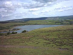
View from Brown Wardle looking out over Watergrove Reservoir, formerly the site of the town of Watergrove.
-
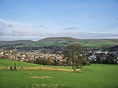
View of Brown Wardle from Cock Hall
-
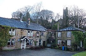
Red Lion pub, Whitworth Square
-
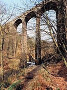
Healey Dell Viaduct
-
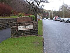
Market Street, Whitworth


See also
 In Spanish: Whitworth para niños
