Burnley facts for kids
Quick facts for kids Burnley |
|
|---|---|
| Town | |
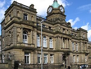
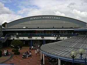
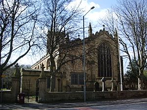
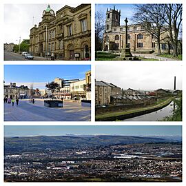 Clockwise from top left: Burnley Town Hall; St Peter's Church; Belle Vue Mill; View of eastern Burnley and the Forest of Pendle; St James's Street in the town centre |
|
| Area | 15.82 km2 (6.11 sq mi) |
| Population | 78,266 (2021 Census) |
| • Density | 4,947/km2 (12,810/sq mi) |
| OS grid reference | SD836326 |
| • London | 181 mi (291 km) SSE |
| District |
|
| Shire county | |
| Region | |
| Country | England |
| Sovereign state | United Kingdom |
| Post town | BURNLEY |
| Postcode district | BB10-BB12 |
| Dialling code | 01282 |
| Police | Lancashire |
| Fire | Lancashire |
| Ambulance | North West |
| EU Parliament | North West England |
| UK Parliament |
|
Burnley (pronounced BURN-lee) is a town in Lancashire, England. It's the main town of the wider Borough of Burnley. In 2021, about 78,266 people lived there. Burnley is about 21 miles (34 km) north of Manchester and 20 miles (32 km) east of Preston. It sits where the River Calder and River Brun meet.
The town is close to beautiful countryside. It's known for its strong manufacturing and aerospace industries. Burnley started as small farming villages in the early medieval period. It has had a market for over 700 years. During the Industrial Revolution, it became a major mill town. At its busiest, it made a lot of cotton cloth. It was also a big centre for engineering.
Today, Burnley still has a strong manufacturing sector. It has good economic links with Manchester and Leeds. In 2013, the UK Government called it the 'Most Enterprising Area in the UK'. Since 2015, you can take a direct train from Burnley Manchester Road to Manchester Victoria.
History of Burnley
What's in a Name?
The name Burnley likely comes from "Brun Lea." This means "meadow by the River Brun." Over time, the spelling changed. Some old spellings include Bronley (1241) and Brumleye (1294).
Early Days
People lived around Burnley a very long time ago. Stone Age tools have been found on the nearby moors. There are also old burial mounds and stone circles. Some hill forts like Castercliff date back to 600 BC. This shows the area was busy even before recorded history.
The Romans were here too, but no big settlements have been found. Some roads they built might have passed through the town. After the Romans, the area became part of different kingdoms.
Burnley was first officially recorded in 1122. A charter gave its church to monks from Pontefract Abbey. Back then, it was a small farming village. It got a corn mill in 1290 and a market in 1294. It had only about 50 families. The old Market Cross from 1295 still stands today.
By 1550, Burnley had grown to about 1,200 people. It was still centred around St Peter's. Richer families built bigger homes like Gawthorpe Hall and Towneley Hall. The town's grammar school started in 1559. By 1790, Burnley was a small market town with about 2,000 people. Weaving became important in the mid-1700s.
The Industrial Revolution
The second half of the 1700s brought big changes. Making cotton started to replace wool. Burnley's first factories used water power from the River Calder and River Brun. They drove spinning machines. In 1754, the first main road, a turnpike, connected Burnley to other towns. This helped the town grow.
Coal mining also grew fast in the 1700s. Deeper mines replaced older, shallow ones. By 1800, there were many coal pits in the town centre.
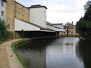
The Leeds and Liverpool Canal arrived in 1796. This allowed goods to be moved in large amounts. It greatly boosted the local economy. Many new mills, foundries, and ironworks were built. These supplied machines and iron for the cotton mills and coal mines. Burnley became famous for its mill-engines. The "Burnley Loom" was known as one of the best worldwide.
In 1824, the local bank collapsed, causing some mills to close. A drought that summer also hurt many mills. This led to many people losing their jobs. By 1830, there were 32 steam engines in cotton mills. One of these is now in the Science Museum in London.
In the 1840s, many Irish families moved to Burnley because of the Great Famine. They formed a community in the Park District. In 1848, the railway connected Burnley to the national network. This was another big boost for the town. By 1851, the population was almost 21,000.
The Lancashire Cotton Famine (1861–1865) was a tough time. It was caused by the American Civil War. But trade soon picked up. By 1866, Burnley was the world's biggest producer of cotton cloth. By the 1880s, it made more looms than anywhere else in the country.
The population grew to 87,016 by 1891. Burnley Town Hall was built between 1885 and 1888. Electricity came to Burnley in 1893, first for street lighting.
By 1901, Burnley's textile industry was at its peak. There were 700,000 spindles and 62,000 looms. Other industries included iron foundries and paper mills. By 1911, the population reached over 100,000. But the First World War marked the start of a decline for the textile industry. The town's population also began to drop.
World Wars and Beyond
Over 4,000 men from Burnley died in the First World War. This was about 15% of the working-age men. Two soldiers from Burnley, Hugh Colvin and Thomas Whitham, received the Victoria Cross. A memorial was built in Towneley Park in 1926 to remember those who died.
During the Second World War, Burnley was mostly safe from bombing. Only a few bombs fell near the town. Factories in Burnley helped the war effort. They made electrical parts and were involved in developing early jet engines. The Old Vic Theatre Company and Sadler's Wells Opera moved to Burnley during the war.
After the war, in 1955, Queen Elizabeth II visited Burnley. In 1960, Burnley FC won the Football League championship. The Queen visited again in 1961. The 1960s saw many old buildings demolished for new ones. These included the Charter Walk shopping centre and a new bus station. The last deep coal mine closed in 1971.
In 1980, the M65 motorway connected Burnley to the motorway network. This led to new housing developments. In 2001, there were some disturbances in the town due to racial tensions.
The "Forest of Burnley" project planted about a million trees around the town.
How Burnley is Governed
Burnley has three levels of government. Local services are handled by Burnley Borough Council and Lancashire County Council. At a national level, the town elects a Member of Parliament (MP) to the UK Parliament.
Local Council
The Burnley Borough Council is currently run by a group of different political parties working together. The mayor's job is mostly ceremonial and changes each year.
The borough has 15 areas called wards. Twelve of these are within Burnley town itself. The other three cover nearby Padiham and some villages.
County Council
Lancashire County Council is currently controlled by the Conservative Party. The borough has six divisions that elect members to this council.
National Parliament
The Burnley constituency elects one MP. In the 2024 election, Oliver Ryan from the Labour Party was elected. Before that, the town had a Conservative MP for the first time in over 100 years. A famous MP for Burnley was Arthur Henderson, a former leader of the Labour Party and a Nobel Peace Prize winner.
Geography of Burnley
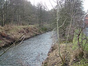
Burnley is in a valley where the River Brun and River Calder meet. It's surrounded by fields and wild moorland. To the west are Padiham, Accrington, and Blackburn. To the north are Nelson and Colne. The town centre is about 118 metres (387 ft) above sea level.
Some areas in town include Burnley Wood, Rose Hill, and Daneshouse. Reedley is often seen as part of Burnley, but it's actually in the neighbouring borough of Pendle.
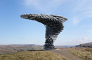
To the northwest is the famous Pendle Hill, which is 557 metres (1,827 ft) high. To the southwest is Hameldon Hill, with a weather radar and radio transmitter. To the east are the moors of the South Pennines. To the south is the Forest of Rossendale. You can see the white turbines of the Coal Clough Wind Farm from most of the town. The unique Singing Ringing Tree sculpture also overlooks the town from Crown Point.
Burnley has a temperate maritime climate. This means cool summers and mild winters. It rains regularly but usually lightly.
People and Population
| The Borough of Burnley compared | |||
|---|---|---|---|
| UK Census 2011 | Burnley | NW England | England |
| Total population | 87,059 | 7,052,177 | 53,012,456 |
| Foreign born | 7.7% | 8.2% | 13.8% |
| White | 87.4% | 90.2% | 85.4% |
| Asian | 10.7% | 5.5% | 7.1% |
| Black | 0.2% | 1.4% | 3.5% |
| Christian | 63.6% | 67.3% | 59.4% |
| Muslim | 9.9% | 5.1% | 5.0% |
| Hindu | 0.2% | 0.5% | 1.5% |
| No religion | 19.7% | 19.8% | 24.7% |
| Under 18 years old | 22.2% | 21.2% | 21.4% |
| Over 65 years old | 16.2% | 16.6% | 16.3% |
| Unemployed | 5.3% | 4.7% | 4.4% |
| Perm. sick / disabled | 7.0% | 5.6% | 4.0% |
In 2001, the population of Burnley was 73,021. The wider area, including Nelson and Colne, had about 149,796 people. In 2011, about 87.4% of people in the borough were white. About 10.7% were of South Asian background. Most people identified as Christian (63.6%) or Muslim (9.9%).
Most of Burnley's Asian residents live in the Daneshouse and Stoneyholme areas. The Asian community here is smaller than in nearby towns like Blackburn or Oldham.
Burnley has some of the lowest property prices in the UK. Many streets with terrace housing near the town centre are very affordable.
| Year | 1911 | 1921 | 1931 | 1939 | 1951 | 1961 | 1971 | 2001 | |||||||||||||
|---|---|---|---|---|---|---|---|---|---|---|---|---|---|---|---|---|---|---|---|---|---|
| Population | 106,322 | 103,157 | 89,258 | 85,400 | 84,987 | 80,559 | 76,489 | 73,021 | |||||||||||||
Burnley's Economy
In 2013, Burnley won an 'Enterprising Britain' award. This means it was the 'Most Enterprising Area in the UK'. The Prime Minister and Prince of Wales praised the town.
Burnley's economy is changing. It has new rail links to Manchester and investments in old industrial areas. While traditional manufacturing has decreased, advanced manufacturing is still very strong. The Secretary of State for Business, Vince Cable, said in 2013 that Burnley was "booming economically" due to manufacturing and its link to the aerospace industry.
The last deep coal mine closed in 1981. The last steam-powered mill, Queen Street Mill, closed in 1982. Over the next 20 years, Burnley's three biggest factories closed. The town has worked hard to recover. Its main job sector is now Health (21%), followed by Manufacturing (16%).
Modern economic growth has focused on industrial estates and business parks. Examples include Heasandford and Network 65. Key manufacturing companies today work in special fields. These include aerospace parts (Safran Aircelle, Unison Engine Components) and professional audio (AMS Neve).
Ian Mankin Ltd continues Burnley's history of fabric weaving. They make high-quality fabrics at Ashfield Mill.
Burnley's main shopping area is St James Street and the Charter Walk Shopping Centre. The town centre has many well-known shops. There are also four retail parks and some mill shops nearby. New plans are in place for a cinema and restaurants in the town centre.
The local brewery, Moorhouse's, makes award-winning beers. Other local breweries also produce cask ales.
Religion in Burnley
St Peter's Church is very old, dating back to the 15th century. It's a Grade II* listed building, meaning it's historically important. St Andrew's Church was built in 1866–67.
The chapel at Towneley Hall was once the main place for Roman Catholic worship. Before the Industrial Revolution, many non-conformist churches opened. In 1891, the Baptist Union of Great Britain was created in Burnley.
Burnley has ten mosques. The first one built specifically as a mosque opened in 2009. In total, 17 religious buildings in Burnley are listed as Grade II historic buildings.
Famous Landmarks
Leeds and Liverpool Canal
The Leeds and Liverpool Canal has some special features in Burnley. The "Straight Mile" is a 1,120-metre (3,675 ft) long, almost perfectly flat embankment. It was built between 1796 and 1801 to avoid needing locks. It's considered one of the original seven wonders of British waterways. The Whittlefield motorway aqueduct (built in 1980) was one of the first canal aqueducts built over a motorway in the UK.
Weavers' Triangle
The Weavers' Triangle is an area west of Burnley town centre. It has many 19th-century industrial buildings near the Leeds and Liverpool Canal. This area is important because its cotton mills show the town's history and the growth of its weaving industry. Since the 1980s, efforts have been made to redevelop this area.
Singing Ringing Tree
The Singing Ringing Tree is a unique wind powered sound sculpture. It looks like a tree and is located in the Pennines, about 2 miles (3 km) south of Burnley.
Finished in 2006, it's part of a project to create new landmarks in East Lancashire. Designed by Mike Tonkin and Anna Liu, it's 3 metres (9.8 ft) tall. It's made of galvanised steel pipes. When the wind blows, it makes a slightly discordant and deep choral sound. Some pipes are for structure, while others are cut to make sound. The sound is created by tuning the pipes based on their length.
In 2007, this sculpture won a National Award from the Royal Institute of British Architects (RIBA).
Towneley Hall
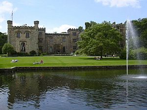
Towneley Hall was the home of the Towneley family for over 500 years. Members of this family were important in science, technology, and religion in the 17th and 18th centuries. The family line ended in 1878. In 1901, Lady O'Hagan sold the house and 62 acres (25 ha) of land to Burnley Corporation.
The hall has a 15th-century chapel. It also contains a beautifully carved altarpiece from about 1525.
Getting Around Burnley
Burnley is connected to the M65 motorway at Junctions 9, 10, and 11. This motorway goes west to Preston (connecting to the M6) and northeast to Nelson and Colne. Other main roads connect Burnley to nearby towns. The A56 road bypasses the town, linking to the M66 motorway towards Manchester.
Burnley has four train stations: Burnley Manchester Road, Burnley Central, Burnley Barracks, and Rose Grove. A fifth station, Hapton, serves Padiham and Hapton.
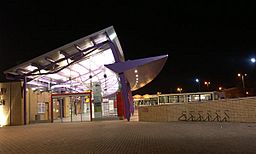
Since May 2015, there's a direct train service from Burnley to Manchester. This journey now takes about 45 minutes. A new building for Manchester Road station was built for this service.
The Burnley bus station won an award in 2003. The main bus company is Burnley Bus Company. There are also long-distance coach services to London and Birmingham. The X43 "Witch Way" bus service runs from Burnley to Manchester.
Burnley doesn't have an airport. However, four international airports are within an hour's drive. These include Manchester Airport and Leeds Bradford Airport. Since 2009, the Reedley Marina offers a place for boats on the Leeds and Liverpool Canal.
Sports in Burnley
The most popular sport in Burnley is football, thanks to Burnley Football Club. They are known as "The Clarets" and started in 1882. They were one of the first professional football clubs. In 1888, they were one of the 12 founding members of the Football League.
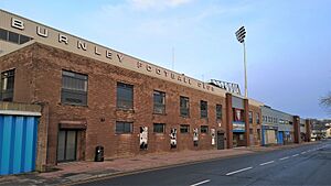
The club plays its home games at Turf Moor. The team is very popular in the town. Burnley FC has won the English championship twice (in 1920–21 and 1959–60). They have also won the FA Cup once (1913–14). Burnley is one of only five English clubs to have won all four professional league divisions.
Burnley has two cricket clubs in the Lancashire Cricket League. Burnley Cricket Club plays at Turf Moor, next to the football ground. England cricketer James Anderson started his career there.
The town also has Burnley Rugby Club. They play at Holden Road. There's also a Rugby League team, Burnley and Pendle Lions RLFC. Burnley Tornados is the American Football club.
Burnley has good public sports facilities. The St Peter's Centre (opened 2006) has swimming, squash, and a gym. The Spirit of Sport complex has a large sports hall and pitches. There's an athletics track at Barden Lane. For golfers, there are courses at Towneley Park and the private Burnley Golf Club. You can also find tennis courts, bowling greens, and a skate park in town. The private Crow Wood Leisure Centre offers fitness, racquet sports, and horse riding.
Culture and Fun
Museums and Art
On the edge of town, you can find art galleries in two large homes: Towneley Hall and Gawthorpe Hall in Padiham. There are also two local museums. The Weavers' Triangle Trust runs a Visitor Centre and Museum of Local History. The Queen Street Mill Textile Museum is special because it's the only steam-powered cotton weaving shed left in the world.
Mid Pennine Arts helps with art projects and exhibitions in the town.
Parks and Green Spaces
Burnley has several large parks. Towneley Park was once a deer park for Towneley Hall. Three parks have won the Green Flag Award: Queens Park (which has summer brass band concerts), and Thompson Park (with a boating lake and miniature railway). Other parks include Scott Park and Ightenhill Park. A greenway path links Burnley Central Station to Rowley Lake.
Activities and Entertainment
There's a modern 24-lane ten pin bowling centre. A 9-screen multiplex cinema opened in 1995. The town's theatre, Burnley Mechanics, hosts comedians, music, and amateur plays. In 2005, Burnley Youth Theatre moved into a new, purpose-built performance space.
Festivals and Events
Each year, Burnley hosts the two-day Burnley International Rock and Blues Festival. It started in 1988 and is one of the biggest blues festivals in the country. It brings fans from all over. In the 1970s, Burnley was also important for Northern soul music. The town has also hosted a Balloon Festival and a science festival. A funfair is usually held in July.
In July 2023, Burnley had its first ever Pride parade.
Nightlife
Burnley has various bars and nightclubs. The town has a small gay scene.
A popular local drink is Bénédictine and hot water, called "Bene 'n' Hot." Soldiers brought the taste for it back from Normandy after the First World War. The Burnley Miners' Club is known for drinking a lot of this French liqueur.
Media and TV Appearances
Local radio for Burnley is provided by Capital Manchester and Lancashire and BBC Radio Lancashire. Local TV news comes from BBC North West Tonight and ITV Granada Reports.
There are two local newspapers: the Burnley Express and the Lancashire Telegraph.
Burnley has been a filming location for TV shows and movies. Parts of the 1961 film Whistle Down the Wind were filmed here. The BBC series All Quiet on the Preston Front and Juliet Bravo also used the town. Queen Street Mill was used in the Oscar-winning film The King's Speech (2010) and other TV shows. Towneley Hall appeared in the BBC drama Casanova.
In 2023, Netflix released the film "Bank of Dave." It tells the story of Burnley businessman David Fishwick.
Education in Burnley
Burnley Grammar School started in 1559. It moved to a new building in 1876. The first technical school opened in 1892.
In 2003, a plan was made to replace all the secondary schools in Burnley. New schools opened between 2006 and 2010.
Today, there are five secondary schools for students aged 11–16:
| School | Locality | Description | Ofsted | Website |
|---|---|---|---|---|
| Blessed Trinity RC Community College | Burnley | Secondary school | 134997 | website |
| Burnley High School | Burnley | Secondary school | 141028 | website |
| Sir John Thursby Community College | Burnley | Secondary school | 134996 | website |
| Shuttleworth College | Padiham | Secondary school | 134994 | website |
| Unity College | Burnley | Secondary school | 135003 | website |
Thomas Whitham Sixth Form offers education for students aged 16 and older. University Technical College Lancashire opened in Burnley in 2013 for 14- to 19-year-olds. Burnley High School is a free school that opened in 2014.
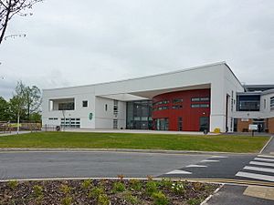
Burnley College is the main college for post-16 education. It offers many courses, including A Levels and vocational training. Burnley College works with the University of Central Lancashire (UCLan Burnley) to provide adult education and degree courses. The college moved to a new £80 million campus in 2009.
Educational results in Burnley have been improving. In 2012, 82% of children achieved Level 4 or above in English at the end of primary school. Burnley College reported a 99.8% A Level pass rate in 2012.
Famous People from Burnley
Arts and Entertainment
- Ian McKellen: A very famous actor, born in Burnley in 1939.
- Other actors: J. Pat O'Malley, Mary Mackenzie, Irene Sutcliffe, Julia Haworth, Jody Latham, Natalie Gumede, and Lee Ingleby.
- Musicians: Members of the band Chumbawamba (Danbert Nobacon, Alice Nutter, Lou Watts, Boff Whalley), Eric Haydock (from The Hollies), and singer Hollie Steel.
- Writers: Silas K. Hocking (author of Her Benny), crime writer Stephen Booth.
- TV creators: Screenwriter Paul Abbott (creator of Shameless), and TV producer Peter Salmon.
Science and Industry
- Sir Willis Jackson: An engineer born and educated in Burnley.
- James Drake: A pioneer of British motorways.
- Richard Towneley: A 17th-century scientist who made many discoveries at Towneley Hall.
- Edwin Southern: A molecular biologist who invented the Southern blot.
Sports Stars
- James Anderson: England and Lancashire cricketer.
- Footballers: Jimmy Crabtree, Billy Bannister, Jay Rodriguez, Oliver Norwood, Adnan Ahmed, Rachel Brown (England Women's goalkeeper), Chris Casper.
- Other athletes: Craig Heap (Commonwealth Games Gold Medal gymnast), Fabian Coulthard (Supercars Championship driver), Neil Hodgson (2003 World Superbike champion), Holly Lam-Moores (handball player), Jock McAvoy (boxer), Sophie Hitchon (hammer thrower).
- Football figures: Bob Lord (long-time Burnley F.C. chairman), Jimmy Hogan (football pioneer).
See also
 In Spanish: Burnley para niños
 | Isaac Myers |
 | D. Hamilton Jackson |
 | A. Philip Randolph |


