River Brun facts for kids
The River Brun is a river in eastern Lancashire, England. It's about 4.5 miles (7.2 km) long. A river's catchment area is all the land where rain falls and drains into that river. The Brun's catchment area is about 24.13 square kilometers (9.32 sq mi).
Quick facts for kids River Brun |
|
|---|---|

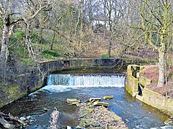
The Brun as it falls over the old weir in Burnley
|
|
| Country | England |
| Physical characteristics | |
| Main source | Hurstwood, Worsthorne, Lancashire |
| River mouth | River Calder, Burnley |
| Length | 4.5 miles (7.2 km) |
Where the River Brun Flows
The River Brun starts near the village of Hurstwood. It begins where two smaller streams, Hurstwood Brook and Rock Water, meet. Hurstwood Brook collects water from Wether Edge and Hameldon hills. Rock Water starts nearby and gets water from Cant Clough Beck and Shedden Clough stream.
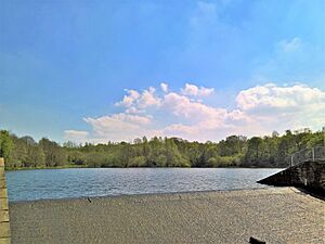
The river then flows northwest towards the town of Burnley. It passes by a place called Ormerod. Here, a small stream from Worsthorne joins the Brun. The river continues past the Hollins and the hamlet of Brownside. It then flows through Rowley Lake, near Rowley Hall.
After this, Swinden Water joins the Brun. Then, the River Don also meets the Brun at Netherwood Bridge. At this point, the Brun turns west.
The river enters Burnley at Heasandford. Here, the Walshaw Clough stream flows into the Brun. The river passes the Burnley Youth Theatre. It then turns southwest, going through Bank Hall Park. It flows under the Leeds and Liverpool Canal. The Brun then enters Thompson Park, where it fills the boating lake. It continues past St Peter's Church.
As the Brun moves through the town center, it goes underground for a short time. This happens at the St Peter's Centre and again under the Charter Walk shopping center. The river then turns west again. Finally, the Brun flows over one last small waterfall. It then joins the River Calder near the Active Way roundabout.
History of the River Brun
Many people believe the River Brun gave Burnley its name. The name "Burnley" might come from old English words meaning "meadow by the brown river." However, it's also possible the town was named first, and then the river got its name from the town.
West of Hurstwood, the Brun flows under Salterford Bridge. This bridge is where an old saltway (a path for carrying salt) used to cross the river. Near where the River Don joins the Brun, you can still see parts of old sluices and dams. These structures used to supply water to a mill lodge for the old Heasandford Mill. This mill was once located further downstream.
Close to St. Peter's Church, you can see parts of an old weir. Water from this weir flowed through a special channel called a goit. This goit led to a lodge that supplied water for the town's old corn mill. This mill was used to grind grain. It is thought to have been built around 1290. It used water power until 1820.
The old bridge near the church was taken down in 1736. A new, wider bridge was built nearby. The last place the river crosses before joining the Calder is called Salford. This area of town was also known by that name in the early 1900s.
The lake at Rowley and the river's path to Heasandford were created in the 1970s. Before this, the river flowed differently. The Don used to collect Swinden Water before meeting the Brun closer to the old mill lodge. Bank Hall was once a big coal mine. It operated for over 100 years until 1971. Another mine was near Rowley Hall, working from 1861 to 1928. The area was used for dumping waste from the mines for many years. The mining caused a lot of pollution in the river. The new river path also allowed the old river valley to be used as a landfill site.
For over 40 years, Lancashire County Council has been working to clean up the river. The Bank Hall site has been turned into a park. They are also creating the Brun Valley Forest Park along the river. This park stretches between Brownside and Heasandford. From 2011 to 2015, a project called the Urban River Enhancement Scheme (URES) helped improve the river's environment in the town. This included building fish passes on the weirs. Fish passes help fish swim over obstacles like weirs.
 | William M. Jackson |
 | Juan E. Gilbert |
 | Neil deGrasse Tyson |


