
River Spodden facts for kids
Quick facts for kids River Spodden |
|
|---|---|

Fairies Chapel, Healey Dell
|
|
| Country | England |
| Physical characteristics | |
| Main source | Freeholds Top, Shawforth, Whitworth, Lancashire |
| River mouth | River Roch, Rochdale 53°36′55.43″N 2°9′59.85″W / 53.6153972°N 2.1666250°W |
The River Spodden is a river in North West England. It's one of the two main rivers that flow into the River Roch. It starts in the Pennine hills of Lancashire, north of Whitworth. The river then flows south through the beautiful Whitworth Valley. It eventually reaches Rochdale, Greater Manchester, where it joins the River Roch. A special place along the river is the Healey Dell Nature Reserve, known for its lovely wooded valley.
Contents
River Spodden: Where It Starts and Flows
The River Spodden begins at a spot called Freeholds Top. This is on Shawforth Moor, near the village of Shawforth in Whitworth. In the early 1800s, people said it started "near High House."
The river flows south through a narrow valley. It passes through towns like Shawforth, Facit, Whitworth, and Broadley. For about one kilometer, it forms the border between the Rochdale and Rossendale areas. It also marks the line between Greater Manchester and Lancashire counties.
After that, it flows through Healey Dell, Lowerfold, and Shawclough. Finally, it reaches Spotland Fold and Spotland Bridge. The River Spodden then joins the River Roch at Mitchell Hey in Rochdale. This meeting point is about four kilometers downstream from where the River Roch's other main river, the River Beal, joins it.
The River Spodden drops 235 meters along its 12-kilometer path. It gets water from nine smaller streams that flow directly into it. Four more streams also add water indirectly.
| Next confluence upstream | River Roch | Next confluence downstream |
| Moss Brook | River Spodden | Sudden Brook |
History of the River Spodden
The River Spodden has a long and interesting history. Its name has changed many times over the years.
River Names Through Time
The river was called "Sprotton" in 1577 and the "Spotton Brook" in 1611. It even gave its name to the area of Spotland. Spotland was one of the first four main areas in the Parish of Rochdale. It was first known as "Spoddenland." The river acted as a border within Spotland, separating its eastern and western parts.
The name "Spotland" was used as early as 1066. A local historian, Dr. Whitaker, wrote in the early 1800s that "Spod" or "Spud" meant "spear" in some old languages. He thought the river got this name because it flowed in a very straight line until it met the River Roch. The area around the Spodden valley was known for keeping old Saxon traditions and language alive.
The road next to the river, north from Spotland Bridge, is still called Spod Lane today. People living nearby even called the river "the Spod" as recently as the late 1970s.
Mills and Factories Along the River
The strong flow of the River Spodden through Healey Dell was used for power a long time ago. It might have powered a corn mill (for grinding grain) even in Anglo-Saxon times. The word "Healey" itself comes from Anglo-Saxon and means "high pasture."
In 1636, the old corn mill became a wool fulling mill (for processing wool). A new corn mill was built further upstream. The remains of the 17th-century mill, which was built over the river, can still be seen. It was known as "Th' Owd Mill i' t' Thrutch."
After this, the river's water was used a lot by factories. By 1851, there were 9 cotton mills and 7 woollen mills in the Rochdale area that used only river power. As factories needed more power, many started using river water to help steam engines. In 1841, 6 cotton mills and 42 woollen mills used water this way.
In total, 30 wool or cotton factories were built along the river. There was also a stone dressing mill, a metal works, and a brick works. The river was very important for industry in the area.
The Old Railway Viaduct
A cool feature of the River Spodden is the old railway viaduct. It's 100 feet (32 meters) high! This bridge was built in 1867 for a railway line that went from Rochdale to Bacup. The viaduct has eight arches and is made from local stone. During its building, the river had to be moved for a bit.
The railway line followed the river's path for a long way. It went from Lower Fold almost to the river's source at Shawforth Moor. The railway was very useful for moving stone and coal from the quarries and mines in the Whitworth valley. The railway line closed in 1967, and the tracks were removed. However, the viaduct is still there. You can walk across it, and a sewer pipe for Rochdale to Whitworth also runs over it.
Turner Brothers Asbestos Works
In 1855, one of the Turner brothers built a cotton mill called Clod Mill next to the river at Spotland Fold. The company Turner Brothers started in 1871. They began making asbestos products like packing and cloth. The company grew very quickly and became famous across the country and even worldwide. The Clod Mill site became much larger.
Later, the company made products that mixed rubber and asbestos, like parts for car clutches and brakes. By 1910, the factory was known as "Asbestos and India Rubber Works." Over time, people learned about the health risks of asbestos. The company faced many claims from workers who had become ill. Because of this, the company began to decline and eventually stopped working at the site. Parts of the factory were taken down starting in 2001, and the process continued until 2013.
The Great Flood of 1838
On July 4, 1838, a huge storm hit the area. It was one of the worst storms people had ever seen. Heavy rain and hail caused the River Spodden to rise very high. Near Spotland Bridge, the water reached 15 feet (4.5 meters)! Spotland Bridge was washed away, along with other smaller bridges.
Many mills and houses near the river were badly damaged. Factories like Healey Hall Mills, Foot Mill, and Meanwood Die Works were almost destroyed. Even the Fairies Chapel in Healey Dell (which we'll talk about next) was damaged. The next day, hailstones weighing as much as 12 ounces (340 grams) were found on Rooley Moor. The hailstorm was so strong that it broke windows in houses and weaving sheds. At Moss Mill in Rochdale, it was said that one thousand panes of glass were broken!
Fairies Chapel: A Magical Place
Another cool spot along the River Spodden is the Fairies Chapel. As the river flows through Healey Dell, it goes into a narrow gorge called the Thrutch. "Thrutch" is an old Lancashire word meaning to push or crowd.
Inside this gorge, the river's water carved out a cave on the side. The rocks there took on strange shapes. People imagined them as a "pulpit, reading desk and seats." This led to the area being called the Fairies Chapel. An old picture of the Fairies Chapel from 1854 can be seen in a history book about Lancaster.
People used to believe in fairies very strongly. A local historian, William Robertson, wrote in 1881 that many working-class people truly believed in fairies. They thought fairies were real beings who helped stop bad things from happening. They especially protected those whom the fairies cared about.
The Fairies Chapel was supposedly controlled by the Fairy Queen. People believed she could see the future. Her most famous prediction was for Lady Eleanor Byron, a relative of the poet Lord Byron. The Fairy Queen told her that she would get married and become a widow on the very same wedding day! Sadly, some parts of the Fairies Chapel were damaged by the big flood in July 1838.
Healey Dell Nature Reserve
The River Spodden is the main feature of the Healey Dell Nature Reserve. Besides the river and the Fairies Chapel, the reserve is home to many kinds of wild flowers and grasses. In autumn, you can see brightly colored fungi, like Wax Caps.
If you stand on the high railway viaduct walkway, you might spot migrating birds in summer. Swifts and martins fly around during the day. In the evening, you can see bats flying. It's a great place to explore nature!
Tributaries of the River Spodden
The River Spodden has many smaller streams that flow into it. These are called tributaries. Here are some of them:
- Red Brook
- Shawclough Brook
- Caldershaw Brook
- Smallshaw Brook
- Dunishbooth Brook
- Prickshaw Brook
- Fern Isle Brook
- Tong End Brook
- Cowm Brook
- Walstead Brook
- Cowm Brook
- Hud Brook
- Knowsley Brook
- Red Shore Brook
More Information Online
- Healey Dell Nature Reserve website
- Healey Dell Heritage Centre & Tea Rooms website
- "Visit Rochdale" website - Healey Dell page
Gallery
-
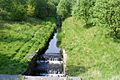
The River Spodden flowing through Facit.
-
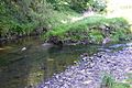
Where Tong End Brook joins the River Spodden.
-
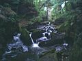
The Fairies Chapel in Healey Dell.
-
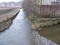
The River Spodden meeting the River Roch in Rochdale.


