Bacup facts for kids
Quick facts for kids Bacup |
|
|---|---|
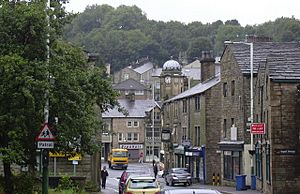 Yorkshire Street, Bacup |
|
| Population | 13,323 (2011 Census) |
| OS grid reference | SD868231 |
| • London | 175 mi (282 km) SSE |
| District | |
| Shire county | |
| Region | |
| Country | England |
| Sovereign state | United Kingdom |
| Post town | BACUP |
| Postcode district | OL13 |
| Dialling code | 01706 |
| Police | Lancashire |
| Fire | Lancashire |
| Ambulance | North West |
| EU Parliament | North West England |
| UK Parliament |
|
Bacup (/ˈbeɪkəp/ BAY-kəp, /ˈbeɪkʊp/) is a town in the Rossendale Borough in Lancashire, England. It is located in the South Pennines, close to the borders of West Yorkshire and Greater Manchester. The town sits in the Rossendale Valley and the upper Irwell Valley. It is about 4 miles (6.4 km) east of Rawtenstall, 6 miles (9.7 km) north of Rochdale, and 7 miles (11 km) south of Burnley. In 2011, Bacup had a population of 13,323 people.
Bacup started as a small village after the Anglo-Saxons arrived in England. For many years, it was known for making flannel and woollen cloth at home. Many of these old weavers' cottages are still standing today. During the Industrial Revolution, Bacup grew into a busy mill town. It was built around a bridge over the River Irwell and a main crossroads. Large woollen and cotton mills became a common sight. In 1882, Bacup was given a special charter, making it a proper town with its own elected government. This government included a mayor and councillors who looked after local matters.
In 1974, Bacup became part of the larger Rossendale borough. Bacup is known for its historic buildings and traditions. Many people see it as one of the best-preserved mill towns in England. English Heritage has even named Bacup town centre a special protected area because of its unique old buildings.
Contents
History of Bacup
The name Bacup comes from an old English word, fūlbæchop. This means "muddy valley by a ridge." The word fūl- meant "foul" or "muddy." It was used in the oldest known mention of the area, around the year 1200. Later, the "ful-" part of the name was dropped. The meaning of -bæchop is not as clear. It might mean "ridge valley" or "back valley," because of its location at the back of the Irwell Valley.
Early Settlements
Archaeologists have found signs that people lived in the Bacup area during the Neolithic (New Stone Age). Anglo-Saxons settled here in the Early Middle Ages. Some stories say that in the 900s, Anglo-Saxons fought against Gaels and Norsemen at Broadclough, a village north of Bacup. For a long time, the River Irwell divided the area into two old church districts: Whalley and Rochdale. Bacup mainly grew in the Whalley area, but it also stretched into Rochdale's Spotland.
Bacup's Industrial Growth
The local landscape was perfect for early industries. There was plenty of water power from the rivers and streams. This helped power early weavers' cottages, coal pits, and stone quarries. When the factory system started during the Industrial Revolution, Bacup changed from a small village into a busy mill town. Many families moved here to work in the cotton mills. Local coal was used to power the quarries, cotton spinning, and shoemaking factories. This helped the local economy grow. In 1882, Bacup officially became a borough with its own local government.
Changes in the 20th Century
Bacup was a very successful and crowded industrial area by the early 1900s. However, the Great Depression and the decline of industries in the UK greatly affected Bacup. Many textile factories closed down. The town also saw its population shrink. From 22,000 people in 1911, it dropped to 15,000 by 1971. The Bacup railway station also closed in 1966. Many buildings became empty and run-down.
Despite these challenges, Bacup has kept its unique "historic character." In 2005, records showed that Bacup had some of the lowest crime rates in the county.
Town Regeneration
In 2013, the Rossendale Borough Council received £2 million from the Heritage Lottery Fund. This money was for a 5-year project to improve Bacup. The project aimed to restore Bacup's historic buildings and cultural heritage. It also offered training in traditional building skills and held events for local people. This investment has helped property prices in the area go up. Bacup is now becoming more attractive to people who travel to bigger cities like Greater Manchester for work.
Bacup 2040 Vision
Because the first project was so successful, the Rossendale Borough Council started the Bacup 2040 Vision and Masterplan in 2019. This new plan aims to make Bacup a modern town. It wants to create a town centre that is less focused on shops and more on visitors and local residents. The council used this plan to apply for money from the Future High Street Fund.
A group called the Bacup 2040 Board was set up in 2019. It includes local residents, business owners, and community groups. This board helps guide the plans for Bacup's future. In February 2020, plans for an £11.5 million redevelopment of Bacup's town centre, including the Market Square, were announced. The first step began in June 2020, with a £1 million project to fix up the old Regal Building.
In 2023, it was announced that Rossendale would receive £17.9 million. Of this, £8.3 million will be used to improve Bacup Market. The plan is to build a new two-story market hall. The ground floor will have local food, crafts, and places to eat and drink. The top floor will have a cycle hub and spaces for creative people to work.
How Bacup is Governed
Bacup has been part of Lancashire for a very long time. In the past, it was a small church area connected to the parishes of Whalley and Rochdale.
Bacup's first local government was set up in 1863. It was called the Bacup Local Board of Health. This group was in charge of keeping the town clean and healthy. In 1882, Bacup was given a special charter, making it a proper borough. This meant it had its own elected town government with a mayor and councillors. This council was based at Bacup Town Hall.
In 1974, the Bacup borough government was ended. Since then, Bacup has been part of Rossendale. This is a larger local government district within Lancashire.
Bacup is represented in the UK Parliament as part of the Rossendale and Darwen area. From 1992 to 2010, the Member of Parliament (MP) was Janet Anderson from the Labour Party. In 2010, Jake Berry from the Conservative Party became the MP. In 2024, Andy MacNae of Labour took the seat.
Geography of Bacup
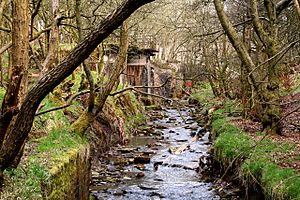
Bacup is located about 15 miles (24 km) north-northeast of Manchester. It is 17 miles (27 km) southeast of Blackburn and 26 miles (42 km) southwest of Bradford. The town sits on the western slopes of the South Pennines, in the upper part of the Irwell Valley. The River Irwell, which is about 39 miles (63 km) long, flows through Bacup towards Rawtenstall. Its source is near the town's outskirts at Weir. In the centre of Bacup, the river flows mostly underground in a culvert. Bacup is about 1,000 feet (300 m) above sea level. The town centre is about 835 feet (255 m) above sea level.
Bacup is surrounded by open moorland and grasslands on most sides. To the west, Stacksteads connects Bacup to Waterfoot and Rawtenstall. The towns of Burnley and Accrington are to the north. Todmorden, Walsden, and West Yorkshire are to the east. Rochdale and Greater Manchester are to the south. Rawtenstall, where Bacup is governed from, is to the west. Some areas and suburbs of Bacup include Britannia, Broadclough, Deerplay, Dulesgate, Stacksteads, and Weir.
Bacup has a temperate maritime climate, like most of the British Isles. This means it has fairly cool summers and sometimes harsh winters. There is usually light rain throughout the year.
Landmarks in Bacup
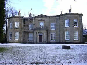
Bacup's main church is called Saint John the Evangelist. Besides this, Bacup has many other churches. Most of Bacup's important buildings were built in the Victorian period. However, there are older notable buildings like Fearns Hall (1699), Forest House (1815), and the 18th-century Stubbylee Hall. The Bacup Natural History Society Museum was started in 1878.
Bacup is home to Elgin Street, which is 17 feet (5.2 m) long. It used to hold the record as the shortest street in the world. But in November 2006, Ebenezer Place in Scotland became the new record holder. Many of Bacup's historic buildings are being restored as part of a £2 million improvement plan.
Transport in Bacup
Bacup railway station opened in 1852. It was the end of the Rossendale line. Another railway line from Rochdale was extended to Bacup in 1883. This line closed to passengers in 1947. The Bacup station finally closed in December 1966, ending all passenger train services.
In June 2014, the police announced they would watch the road between Weir and Bacup (which goes through Broadclough). This road had become a dangerous spot with many serious accidents and even deaths.
A671 Bypass Proposals
There have been many road accidents on the A671 as it goes through the small villages of Broadclough and Weir near Bacup. Some of these accidents have been fatal. Local residents and County Councillor Jimmy Easton have asked for a bypass road to be built. They suggest using parts of Bacup Old Road for this new route.
Culture and Community
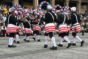
A very important day in Bacup's cultural year is Easter Saturday. On this day, the Britannia Coconut Dancers perform a special dance procession around the town. The Britannia Coconut Dancers are an English country dance group from Bacup. Their dances are part of local folk traditions. They wear special costumes and paint their faces black. People believe their traditions come from Moorish, pagan, medieval, mining, and Cornish customs. The Easter Saturday procession starts every year at the Traveller's Rest Public House on the A671 road. The dancers are joined by members of the Stacksteads Silver Band and dance through the streets.
Bacup Museum is a local history centre and exhibition space. The Bacup Natural History Society was formed in 1878. Volunteers run the society and the museum. The museum has many collections about home life, military history, industry, nature, and religion.
Bacup has been used as a filming location for several TV shows and movies. These include the 1980s BBC police drama Juliet Bravo, Hetty Wainthropp Investigates, parts of The League of Gentlemen, and the film Girls' Night. Some scenes from the BBC TV drama Oranges Are Not the Only Fruit were also filmed in Bacup. The famous 1961 British film Whistle Down the Wind starring Hayley Mills also used various parts of Bacup for filming. The comedy drama Brassic is also largely filmed in Bacup.
Media
Local news and TV shows for Bacup are provided by BBC North West and ITV Granada. TV signals come from the Winter Hill and local relay transmitters.
Local radio stations include BBC Radio Lancashire (95.5 FM), Heart North West (105.4 FM), Capital Manchester and Lancashire (107.0 FM), Greatest Hits Radio Lancashire (96.5 FM), and Rossendale Radio (104.7 FM), which is a community radio station.
The local newspaper for the town is the Lancashire Telegraph.
The Sky TV comedy Brassic is partly filmed in Bacup.
Notable People from Bacup
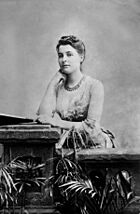
- Lawrence Heyworth (1786–1872), a Member of Parliament and activist.
- Isaac Hoyle (1828–1911), a mill-owner and politician.
- Emily Sarah Holt (1836–1893), an English children's novelist.
- John B. Sutcliffe (1853–1913), an English-American architect.
- Beatrice Webb (1858–1943), a famous sociologist and social reformer. She lived among textile factory workers in Bacup in the 1880s.
- Sir John Maden (1862–1920), a politician who was an MP for Rossendale.
- Herbert Bolton (1863–1936), a palaeontologist and museum director.
- Betty Jackson (born 1949), a fashion designer. Her father owned a shoe factory in Bacup.
- Johnny Clegg (1953–2019), a South African musician.
- Paul Stephenson (born 1953), a former Metropolitan Police Commissioner.
- Jennie McAlpine (born 1984), an actress who plays Fiz Stape in Coronation Street.
- Sam Aston (born 1993), an actor who plays Chesney Brown in Coronation Street.
Sports Figures
- Eddie Cooper (1915–1968), a cricketer who played for Worcestershire.
- Everton Weekes (1925–2020), a famous cricketer who lived in Bacup and played for Bacup Cricket Club.
- Marc Pugh (born 1987), a footballer with over 470 club games.
- Matty James (born 1991), a footballer for Wrexham A.F.C.
- Reece James (born 1993), a footballer for Rotherham United F.C..
See also
In Spanish: Bacup para niños
 | Sharif Bey |
 | Hale Woodruff |
 | Richmond Barthé |
 | Purvis Young |


