
Prestwich facts for kids
Quick facts for kids Prestwich |
|
|---|---|
 Church of St Mary the Virgin, Prestwich |
|

Prestwich
|
|
| Population | 31,500 |
| OS grid reference | SD814034 |
| • London | 166 mi (267 km) SE |
| Metropolitan borough | |
| Metropolitan county | |
| Region | |
| Country | England |
| Sovereign state | United Kingdom |
| Post town | MANCHESTER |
| Postcode district | M25 |
| Dialling code | 0161 |
| Police | Greater Manchester |
| Fire | Greater Manchester |
| Ambulance | North West |
| EU Parliament | North West England |
| UK Parliament |
|
Prestwich is a town in Greater Manchester, England. It's about 3 miles (5 km) north of Manchester city centre. It's also 3 miles (5 km) north of Salford and 5 miles (8 km) south of Bury.
Prestwich has always been part of the historic county of Lancashire. It was home to an old church called St Mary's Church, which is a very important historic building. Today, Prestwich is a popular place for people who work in Manchester to live. It has even been called the 'new Didsbury', comparing it to another well-off area in the south of the city. The Sunday Times has often said Prestwich is one of the best places to live in the UK.
The oldest part of Prestwich is called Prestwich Village, located around Bury New Road. Prestwich is also known for its large Jewish community. This community, along with those in nearby Whitefield, Broughton, and Crumpsall, forms the second largest Jewish community in the UK outside of London.
Contents
What's in a Name?
The name Prestwich probably comes from old English words. Preost means 'priest' and wic means 'farm'. So, Prestwich could mean 'the priest's farm' or 'priest's retreat'. The word wic also comes from the Latin word vicus, meaning 'place', and often meant a 'dairy farm'.
The town's name has been written in different ways over time. For example, it was called Prestwich in 1194, Prestwic in 1202, and Prestewic in 1203.
A Look Back in Time
Early Days


Bury New Road, a main road today, generally follows an old Roman road. This Roman road connected forts in Manchester (called Mamucium) and Ribchester (called Bremetennacum). Some people think a Roman fort might have been built at "Castle Hill" near the border with Salford. This fort might have protected cattle kept in the nearby woods. Roman coins have been found in the area, including near Prestwich Golf Course.
In 1972, a collection of 65 silver coins from the time of King Stephen was found in the Sedgley Park area. Prestwich became a manor (a large estate) in the Middle Ages. In 1212, it was owned by Adam de Prestwich. The lord of the manor was also in charge of the local church. Over the centuries, the ownership of the manor changed hands many times between different families, including the Langleys and the Coke family.
In 1794, Peter Drinkwater bought the manor. His family owned it until 1861. Later, his home, Irwell House, and Drinkwater Park were sold to the local councils. In the 1600s and 1700s, local rules were managed by the church and parish officers. Local judges met in the "Star Chamber" at the Ostrich Inn, which is now called the Church Inn. The village even had stocks (a device used for punishment) until 1800.
How Prestwich Grew
The town first grew around the parish church, making Church Lane the old town centre. In the late 1700s, Prestwich was mostly countryside with a few farms. The population was around 670 people. Areas like Rooden Lane were known for hand loom weaving, and silk weaving was done in Simister and Bowlee.
During the 1800s, more small settlements appeared. When the railway arrived in 1881, wealthy business people from Manchester started building large houses and moving to Prestwich.
Prestwich Hospital, a large hospital for mental health, was built in 1851. By 1900, it was the biggest of its kind in Europe. Sedgley Park Teacher Training College opened in Prestwich in 1903. By 1912, the population had grown to 12,800. From the 1930s, the remaining open land was built on, and by 1961, the population reached 31,000. Prestwich had become a busy suburb of Manchester.
How Prestwich is Governed
Local History
Historically, Prestwich was the main church area for a large ancient parish called Prestwich-cum-Oldham. In 1867, a local board was set up to manage health and other local matters. This board later became the Prestwich Urban District in 1894. Some nearby areas were added to it.
In 1903, Heaton Park became part of the City of Manchester. In 1933, a part of Prestwich was added to another district. Prestwich officially became a municipal borough in 1939, with its own council based at Prestwich Town Hall. However, in 1974, under a new law, Prestwich became part of the Metropolitan Borough of Bury in Greater Manchester.
Where is Prestwich?
Prestwich is located east of the River Irwell. To the north is Whitefield, to the east is Heaton Park, and to the west is Prestwich Forest Park and the Irwell Valley. To the south is the City of Salford. Two main roads, Bury New Road (A56) and Bury Old Road, run through Prestwich from central Manchester to Bury.
The ground beneath Prestwich has coal and sandstone from a very old geological period. On top of this, there is sand, gravel, and clay left behind by glaciers.

People of Prestwich
The 2021 census showed that about 31,500 people live in Prestwich.
Jewish Community
About 20% of the people in Prestwich are Jewish. This area, along with nearby Whitefield, Broughton, and Crumpsall, has the second largest Jewish community in the UK outside of London.
The Jewish community is especially strong around the Sedgley Park area in the south of Prestwich. Here you can find several synagogues, as well as Jewish shops and delis along King's Road, Bury New Road, and Bury Old Road.
How the Population Changed
| Population growth in Prestwich 1881–1971 | ||||||||||||
|---|---|---|---|---|---|---|---|---|---|---|---|---|
| Year | 1881 | 1891 | 1901 | 1911 | 1921 | 1931 | 1939 | 1951 | 1961 | 1971 | ||
| Population | 8,627 | 10,485 | 12,839 | 17,195 | 18,750 | 23,881 | 32,594 | 34,466 | 34,191 | 32,825 | ||
|
Prestwich CP/Tn |
||||||||||||
What Prestwich is Known For

The main shopping area in Prestwich is around the Longfield Centre. This centre, which used to have a community hall, library, and health clinic, is planned to be updated starting in 2024. The Sunday Times describes Prestwich as an "interesting mix of old and new," with modern bars and restaurants alongside traditional places. Many local pubs are run by Joseph Holt.
In the Sedgley Park area, you can find several kosher restaurants and delis. Prestwich is now seen as a well-off area and has been called the "Didsbury of North Manchester."
Getting Around Prestwich

Getting around Prestwich is easy thanks to Transport for Greater Manchester. The town has good transport links to Manchester city centre, Bury, and other parts of Greater Manchester.
Prestwich has four tram stations on the Manchester Metrolink line that goes from Manchester to Bury. These stations are Besses o' th' Barn, Prestwich, Heaton Park, and Bowker Vale. You can park your car at Besses and Prestwich stops, but a larger park-and-ride is available at Whitefield. The Metrolink line used to be a train line, and Prestwich station was first built in 1879.
Bury New Road is the main road through the town. Buses run frequently between Prestwich, central Manchester, and Bury. Local bus routes also connect Prestwich to areas in Salford like Pendlebury and Swinton. Express bus services link Prestwich to Manchester and other towns further north. Bury New Road was first built in 1826.
The M60 motorway also crosses Bury New Road at Junction 17, which is just north of Prestwich town centre.
Places to See
Historic Buildings
-
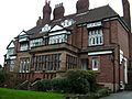
A beautiful Arts and Crafts building on Hilton Lane, built around 1880.
-
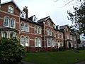
Beech Tree Bank on Rectory Lane, with renovated Victorian houses built in 1881.
-
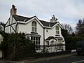
Poppythorn Cottage on Poppythorn Lane.


Parks and Nature
Richard Buxton, a shoemaker, wrote a guide to plants around Manchester in 1849. He noted that places like Prestwich Clough and Mere Clough were home to many interesting plants.
In 1906, Prestwich Clough, a "sylvan and beautiful" area, was opened to the public as a park. Today, Prestwich Forest Park covers about 200 hectares (500 acres) on the western side of Prestwich. It includes Philips Park, Prestwich Clough, Mere Clough, Waterdale Meadow, and Drinkwater Park.
Much of this park area used to be industrial in the 1700s and 1800s. Now, it has been restored with lots of woodlands, reservoirs, and grasslands, becoming a home for wildlife. You can still see hints of its industrial past. Philips Park is a special Local Nature Reserve, and Prestwich Clough is important for its wildlife. The Irwell Sculpture Trail and a National Cycle Route both go through the park. Philips Park Barn has been renovated and is now a centre for environmental education.
Schools in Prestwich
Prestwich has four secondary schools: The Heys School, St Monica's High School, Parrenthorn High School, and Manchester Mesivta School. St Monica's is a Catholic school, and Mesivta is a Jewish school. For further education after secondary school, students usually go to Holy Cross College or Bury College in Bury.
Places of Worship
The Parish Church of St Mary the Virgin is a very old and important building, dating back to around 1500. It was the main church for a large area.
St Margaret's Church was built near Heaton Park in 1849. It became its own parish church in 1885. This church is known for its beautiful oak carvings by Arthur Simpson of Kendal. Other Anglican churches in the area include St Gabriel's, St Hilda's, and St George's.
The Roman Catholic Church became more active in the late 1800s. The current Catholic church, called Our Lady of Grace, opened in 1931.
There are also two Methodist churches: Heaton Park Methodist Church and Prestwich Methodist Church. The Congregational Church on Bailey Street was originally designed by a famous architect, Alfred Waterhouse, in 1864.
As more Jewish families moved to Prestwich, especially from nearby Manchester and Salford, synagogues were built. The 1934 Holy Law Synagogue was the first purpose-built synagogue in Prestwich. There are also Jewish cemeteries in Philips Park, Prestwich Village, and Rainsough.
Sports and Activities
The most well-known football team in Prestwich is Prestwich Heys A.F.C.. They play in a league called the North West Counties Football League. Other local teams include Prestwich F.C. and Prestwich Marauders F.C.
Prestwich Cricket, Tennis & Bowling Club is one of the oldest sports clubs in the Manchester area. It offers cricket, crown green bowling, tennis, and football.
You can also play golf at Prestwich Golf Club and crown green bowling in St. Mary's Park. Nearby Heaton Park also has bowling greens that were built for the 2002 Commonwealth Games.
Culture and Media
You can read local news in The Prestwich and Whitefield Guide and The Bury Times. The Jewish Telegraph newspaper is also made and printed in Prestwich.
The Longfield Centre used to have a large civic hall with a special dance floor, but it closed in 2021. There are several private clubs in Prestwich, like Prestwich Church Institute and the Carlton Club. There are also political clubs for the Conservative and Liberal parties.
Famous People from Prestwich
Many interesting people have connections to Prestwich:
- Celia Birtwell, a textile and fashion designer, grew up here.
- Jenny Frost, a singer from the band Atomic Kitten, went to school in Prestwich.
- Liam Frost, a musician and singer, grew up in the town.
- Guy Garvey, the lead singer of the band Elbow, lives in Prestwich.
- Kevin Godley and Lol Creme from the band 10cc were from Prestwich.
- Howard Jacobson, an author and winner of the Man Booker Prize, was born and raised here.
- Abbie McManus, a footballer for Manchester United and England.
- Arlene Phillips, a famous choreographer, was born in Prestwich.
- Mark E. Smith, the lead singer of the band The Fall.
- William Sturgeon, a physicist and inventor who created the first electric motor, lived and is buried in Prestwich.
- Victoria Wood, a well-known writer, comedian, and actress, was born in Prestwich.
Images for kids
-
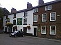
The Church Inn (formerly the Ostrich Inn) next to St Mary's Church
-
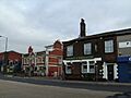
The White Horse (left) and the Railway and Naturalist (right), Prestwich Village
-
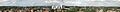
Prestwich Panorama taken from the tower of the Church of Saint Mary the Virgin
-
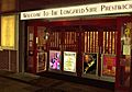
Longfield Suite main entrance
-
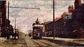
Tram to Manchester passing through Prestwich village in 1904
-
Arts and Crafts, grade II listed building on Hilton Lane, built c1880
-
Beech Tree Bank, Rectory Lane. Renovated Victorian villas built 1881
-
Poppythorn Cottage on Poppythorn Lane
-
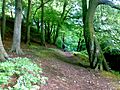
One of the trails to Mere Clough

