Pendlebury facts for kids
Quick facts for kids Pendlebury |
|
|---|---|
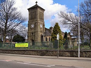 St John's Church, Pendlebury |
|
| Population | 13,069 (2011) |
| OS grid reference | SD790012 |
| • London | 167 mi (269 km) SE |
| Metropolitan borough | |
| Metropolitan county | |
| Region | |
| Country | England |
| Sovereign state | United Kingdom |
| Post town | MANCHESTER |
| Postcode district | M27 |
| Dialling code | 0161 |
| Police | Greater Manchester |
| Fire | Greater Manchester |
| Ambulance | North West |
| EU Parliament | North West England |
| UK Parliament |
|
Pendlebury is a town in Greater Manchester, England. It is part of the City of Salford. In 2011, about 13,000 people lived there. Pendlebury is located about 4 miles (6 km) north-west of Manchester. It is also 3 miles (5 km) north-west of Salford and 6 miles (10 km) south-east of Bolton.
Long ago, Pendlebury was part of Lancashire. It joined with nearby Swinton and Clifton to form the area called Swinton and Pendlebury. For many years, Pendlebury was a busy coal mining town. Mines like Agecroft Colliery operated here until the 1990s.
Contents
Discovering Pendlebury's Past
How Pendlebury Got Its Name
The name Pendlebury comes from old words. Pen is a Celtic word meaning "hill." Burh is an old English word for "settlement." So, Pendlebury means "settlement on a hill." Over time, its name was spelled in different ways. Some old spellings include Penelbiri, Pennilbure, and Pennebire.
Early Land Owners and Families
In 1199, King John gave a piece of land called Peneberi to a man named Ellis. Ellis was an important official in Salford. Later, in 1201, Pendlebury was connected to the nearby area of Shoresworth.
The land was passed down through different families. One important family was the Langleys. They owned the manor of Pendlebury until the late 1500s. After them, the Daunteseys and then the Coke family owned the land. Around 1780, it was sold to Peter Drinkwater.
Agecroft Hall: A Historic Home's Journey
Agecroft Hall was a large Tudor-style house. It was the home of the Lord of the Manor of Pendlebury. The house was built around the end of King Henry VII's reign. In 1666, it was the biggest house in Pendlebury. It had eleven fireplaces!
By the late 1800s, factories and mines grew around Agecroft Hall. The area became industrial and dirty. The house started to fall apart. In 1925, it was sold at an auction. A couple named Mr. and Mrs. Thomas C. Williams bought it. They carefully took the house apart. Then, they shipped it across the Atlantic Ocean to the United States. It was rebuilt in Richmond, Virginia. Today, Agecroft Hall is a tourist attraction. It looks like it did in its original setting by the River Irwell.
The Langley family name is still remembered in the area. There are streets like Langley Road and a housing estate called Langley in Middleton.
Pendlebury's Industrial Story
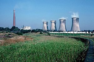
Pendlebury was a major coal mining area. This continued until Agecroft Colliery closed in the 1990s. Other mines included Wheatsheaf Colliery and Newtown Colliery. Agecroft Colliery was reopened in 1960 after a huge investment. It sent much of its coal to the nearby Agecroft Power Station using a conveyor belt. Mining stopped in 1990. Now, the Agecroft Colliery site is a business park.
Miners in the area had their own groups. The Kearsley, Clifton, Pendlebury and Pendleton Miners' Association started in 1888. It later became part of the National Union of Mineworkers. As mining declined, the local Miners' Club was taken down in the 1990s.
How Pendlebury is Governed
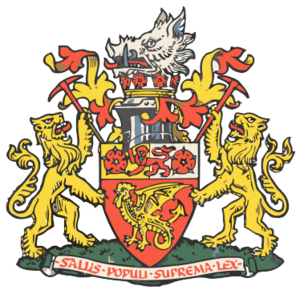
Pendlebury used to be a small area called a "township." In 1866, it became its own civil parish. Then, in 1933, it joined with Swinton to form Swinton and Pendlebury. In 1931, the parish had a population of 9,335 people.
Swinton and Pendlebury became a municipal borough in 1934. This meant it had its own local government. They needed a new town hall. The current Salford Civic Centre was built and opened in 1938. Since 1974, it has been the main office for the larger Salford City Council.
Today, Pendlebury is part of the City of Salford. For national elections, it is part of the Salford and Eccles constituency.
Pendlebury's Location and Landscape
Pendlebury is on a ridge, which is like a long, raised area of land. It looks over the Irwell Valley. The town is located almost exactly between Manchester and Bolton. Its neighbours include Irlams o' th' Height, Pendleton, and Clifton.
The land generally slopes upwards from the southwest to the northeast. The height ranges from about 120 feet (37 m) to nearly 300 feet (91 m) above sea level. However, some areas have changed. This is because mining waste was dumped there. The area around Lumn's Lane has been used as a landfill site since 1982.
Pendlebury has a mix of industrial and residential areas. This is true even though its mines and most of its cotton mills have closed.
Economy and Businesses
In the 1800s, making and printing cotton were the main jobs in Pendlebury. Most of these industries are gone now. The only mill left is Newtown Mill on Lees Street. It was bought in 2008 and turned into a business centre.
The Greater Manchester Fire and Rescue Service has its main office in Pendlebury. It is on Bolton Road.
The site of the old Agecroft Power Station is now home to Forest Bank Prison. The former Agecroft Colliery site has been turned into an industrial park. This has created some jobs in the town.
Getting Around Pendlebury
Roads for Travel
The A666 Bolton Road starts in Pendlebury. It runs through the town. This road was the main way to get between Manchester and Bolton. That was before the M61 motorway opened.
Waterways: The Canal's Role
The Manchester, Bolton and Bury Canal opened in 1809. For many years, it was the main way to move coal from the mines. Many mines built small railways to connect to the canal. Coal was sent to Bolton, Bury, Radcliffe, Salford, and Manchester. In 1905, over half a million tons of coal were carried each year.
Parts of the canal sank because of mining. The canal was not used much after 1924 and closed in 1961. However, coal was still carried a short distance to Bury until 1968. A group started in 1987 to restore the canal. Work to restore it was announced in 2002.
Railway Connections
The closest train station is Swinton. It is actually on the Pendlebury side of the border. This station is on the line between Wigan and Manchester Victoria. Trains run regularly to Manchester, Wigan, Blackburn, and Leeds.
Pendlebury railway station was also on this line for over 80 years. It closed in 1960 because not many people used it. Another nearby station, Irlams o' th' Height, closed four years earlier for the same reason.
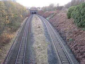
Pendlebury was also on a train line that connected Patricroft and Clifton Junction. But in 1953, the Black Harry Tunnel collapsed. This caused two houses to fall into the hole, and five people died. The line never reopened. Much of it is now a walking path.
Important Places in Pendlebury
Agecroft Cemetery
The Northern or Agecroft Cemetery is a large burial ground. It opened in 1903. It is located near the River Irwell. A crematorium was added in 1957. There is a plan to restore the old central burial chapel, which is not used anymore.
St Augustine's Church
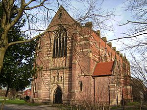
One of the most beautiful buildings in town is St Augustine's Church. It was designed by a famous architect, George Frederick Bodley, between 1871 and 1874. It is a very important historical building. People called it the "miners' cathedral" because it looked so grand and many local men worked in the mines.
The churchyard has a memorial for 178 men and boys. They died in a mining accident at Clifton Hall Colliery in 1885. Sixty-four of the victims are buried at St Augustine's. In 2006, the church was part of a campaign to save old places of worship in Greater Manchester.
Other Landmarks
The Royal Manchester Children's Hospital was built in 1873. It closed in 2009. Its services moved to a new site in Manchester.
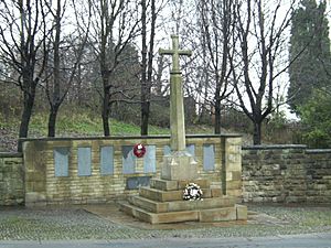
At the corner of Bolton Road and Agecroft Road, there is a stone cross. It says "Lest We Forget." Behind it, a stone wall remembers the brave men from Andrew Knowles and Sons' mines. These men died for their country during 1914–1918. The wall lists the names of 24 men.
Sports in Pendlebury
The former home of Swinton RLFC, a rugby league team, was in Pendlebury. It was called Station Road. Many international and big rugby league games were played there before it closed in 1992. Swinton Lions hope to return to a site in Pendlebury called Agecroft Farm.
Langworthy ARLFC and Folly Lane ARLFC are local rugby teams. They have been based in Pendlebury for many years.
The churchyard of St. John the Evangelist is the burial place of Geoff Bent. He was a football player for Manchester United F.C. and one of the "Busby Babes." He died in the Munich air disaster in 1958. Jim Valentine, a famous rugby player for Swinton, is also buried there.
The Pendlebury Coyotes won the amateur World Championship in inline hockey for under-21s in 2006. They were also runners-up in the senior World Championship.
Schools in Pendlebury
Primary Schools
- Mossfield Primary School, Newtown
- St Augustine's CE Primary School
- St John's CE Primary School
Secondary Schools
- Co-op Academy Swinton
Churches in Pendlebury
- St. Augustine's C of E, Bolton Road, Pendlebury
- St Mark's RC, Station Road, Pendlebury
- Christ Church – Assemblies of God (formerly C of E), Bolton Road, Pendlebury
- Kings Church Salford, Bolton Road, Pendlebury
- St John the Evangelist C of E, Bolton Road, Pendlebury
- Salvation Army, Station Road, Pendlebury
Famous People from Pendlebury
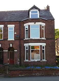
The famous painter L. S. Lowry (1887–1976) lived in Pendlebury. He lived at 117 Station Road from 1909 to 1948. Lowry was 22 when his family moved there. He got many ideas for his paintings from the industrial scenes around him. It is said that he missed a train one day. He saw workers leaving Acme Mill and was amazed. This made him decide to paint industrial scenes. Many of his paintings show parts of Pendlebury. For example, Coming from the Mill (1930) shows parts of Acme Mill. His painting Pendlebury Scene also shows the mill. In 1953, Lowry painted The Railway Platform, showing people at Pendlebury railway station.
Actor Ben Kingsley, born in 1943, grew up in Pendlebury. He lived next door to Lowry's old home on Station Road.
Television writer Tony Warren was born in Pendlebury in 1936. He is best known for creating the popular TV show Coronation Street. It is one of the longest-running TV shows in the UK.
Manchester United football star Ryan Giggs grew up in Pendlebury. His family moved there from South Wales. His father, Danny Wilson, played rugby for Swinton R.L.F.C.. In 2009, Ryan Giggs was given the freedom of Salford.
 | Toni Morrison |
 | Barack Obama |
 | Martin Luther King Jr. |
 | Ralph Bunche |


