
Chorlton-cum-Hardy facts for kids
Quick facts for kids Chorlton-cum-Hardy
|
|
|---|---|
 Chorlton Green |
|

Chorlton-cum-Hardy
|
|
| Population | 14,138 (2011) |
| OS grid reference | SJ815935 |
| • London | 180 miles |
| Metropolitan borough | |
| Metropolitan county | |
| Region | |
| Country | England |
| Sovereign state | United Kingdom |
| Post town | MANCHESTER |
| Postcode district | M21 |
| Dialling code | 0161 |
| Police | Greater Manchester |
| Fire | Greater Manchester |
| Ambulance | North West |
| EU Parliament | North West England |
| UK Parliament |
|
Chorlton-cum-Hardy is a suburb or area in Manchester, England. It is about 3 miles (4.8 km) southwest of the city centre. In 2011, the Chorlton ward had about 14,138 people, and Chorlton Park had 15,147.
Around the 9th century, Anglo-Saxon people settled here. In the Middle Ages, better ways of draining land helped the population grow. Later, in the late Victorian and Edwardian times, many middle-class families liked Chorlton because it felt like the countryside.
In the 1970s, the area changed when its railway station closed and large houses became flats. Also, many new homes were built for social housing. Today, the Manchester Metrolink tram stop, called Chorlton, is on the site of the old railway station. Trams from Manchester Airport and East Didsbury serve this stop.
Historically, Chorlton was a village in Lancashire, near its border with Cheshire. It was part of the larger Manchester area and became part of the city of Manchester in 1904. Chorlton is next to places like Stretford, Sale, Didsbury, Withington, and Whalley Range. The River Mersey flows along Chorlton's southern edge.
Contents
History
What's in a Name?
The name Chorlton probably comes from an Old English name, "Ceolfrith's farm" or "settlement." The word tūn means an enclosed farm or village. Hardy might come from a personal name, Hearda, and ēg, which means an island or dry land in a wet area. Some people think Hardy might mean "by the woods," referring to an old forest called Arden Wood near the River Mersey.
Chorlton was recorded with different spellings over time, like Chollirton in 1250 and Chourton in 1572. The full name, Chorlton-cum-Hardy (cum is Latin for "with"), was not used until the 1700s. This longer name helped people tell it apart from Chorlton-on-Medlock when the railway arrived in 1880.
Early Days
Chorlton was part of the kingdom of Northumbria from the 600s. The area we call Chorlton-cum-Hardy today includes old settlements like Chorlton, Hardy, Barlow, and Martledge. Chorlton was part of the Withington manor, which was a large estate.
Barlow was home to the Barlow family, who lived in Barlow Hall for many years. This hall was built on high ground near the River Mersey for defense. One famous member of the family was Ambrose Barlow, a priest who was executed in 1641 for his beliefs.
In 1640, about 85 people lived in Chorlton. By 1801, the population grew to 513, and by 1851, it was 761. In 1841, a survey showed that two main landowners, Wilbraham Egerton and George Lloyd, owned most of the land. Much of the land was used for growing crops or raising animals. The village had a few old halls, scattered farms, and two pubs: the Bowling Green (built in 1693) and the Horse and Jockey.
Marl, a type of soil, was dug in Martledge for a long time. The empty pits filled with water, giving the area the nickname "the Isles." A brick company also made bricks there for about 40 years.
Growing into a Suburb
Chorlton's population grew slowly until the late 1800s. When the railway reached nearby Stretford in 1849, nice houses were built in Chorlton. A road called Wilbraham Road was built in 1869.
The Midland Railway opened a line through Chorlton station in 1880. After this, land near the station was developed for homes and shops. People who worked in Manchester city centre moved to Chorlton for its good quality homes and more rural feel.
Many Irish immigrants came to work in Manchester's growing industries, in farming, and as domestic helpers. They brought their Roman Catholic faith, and by the early 1900s, a church (St Augustine's) and a school were built.
The Manchester Corporation's tramway also helped Chorlton grow before the First World War. A special area called Chorltonville was built as a "garden suburb" south of Chorlton Brook. Its houses are large and unique, on tree-lined streets. Alexandra Park Aerodrome, Manchester's first big airfield, was located east of the railway.
After the First World War, more homes were built, including a council housing estate at Merseybank. From the 1960s, more council homes were built, and some areas were redeveloped. People from the Indian subcontinent and Poland also moved to Chorlton.
Governance
How Chorlton is Governed
Chorlton was once a small area within the old parish of Manchester in Lancashire. Local government became more organized in the 1840s. Chorlton was part of the Withington Urban District from 1894 to 1904. In August 1904, Chorlton became part of the City of Manchester.
Border with Trafford
In 1987, the border between Manchester and Trafford changed. This meant that places like Stretford Stadium and the Jackson's Boat pub, which people thought were in Chorlton, were now officially in Stretford and Sale.
Geography
| Weather chart for Chorlton-cum-Hardy | |||||||||||||||||||||||||||||||||||||||||||||||
|---|---|---|---|---|---|---|---|---|---|---|---|---|---|---|---|---|---|---|---|---|---|---|---|---|---|---|---|---|---|---|---|---|---|---|---|---|---|---|---|---|---|---|---|---|---|---|---|
| J | F | M | A | M | J | J | A | S | O | N | D | ||||||||||||||||||||||||||||||||||||
|
70
8
2
|
70
8
2
|
50
10
3
|
63
13
5
|
51
16
8
|
58
19
10
|
54
21
12
|
69
21
12
|
63
18
10
|
88
14
7
|
82
10
4
|
78
7
2
|
||||||||||||||||||||||||||||||||||||
| temperatures in °C precipitation totals in mm source: World Weather Online |
|||||||||||||||||||||||||||||||||||||||||||||||
|
Imperial conversion
|
|||||||||||||||||||||||||||||||||||||||||||||||
The old area of Chorlton-cum-Hardy covered about 1280 acres (518 hectares) of flat land on the north side of the River Mersey. In medieval times, it was part of the Manor of Withington. The highest point is in the southeast, just over 100 feet (30 meters) above sea level. The Chorlton Brook flows through the area from east to west, joining the Mersey. Chorlton grew north of this brook.
Chorlton is surrounded by Stretford, Sale, Didsbury, Withington, and Whalley Range.
Chorlton's weather is usually mild, without extreme temperatures. The average temperature is a bit higher than the UK average. The amount of rain and sunshine is slightly below the UK average.
Between Chorlton Brook and the river, you'll find the Chorlton Ees Nature Reserve. This area used to be a sewage works but was cleaned up in 1972. Now it has trails through grasslands and woodlands. In the 1970s, gravel was dug from the Mersey floodplain at Barlow Hall Farm to build the M60 motorway. The area around the flooded gravel pit was turned into Chorlton Water Park, which is now a Local Nature Reserve.
Chorltonville, a special "garden village" covering 36 acres (15 hectares), was built in 1911. It became home to many professional families.
 |
Stretford | Old Trafford | Whalley Range | |
| Sale | Withington | |||
| Sale | Wythenshawe | Didsbury |
Demography
Population Change
| Population change in Chorlton-cum-Hardy | |||||||||||||||||||
|---|---|---|---|---|---|---|---|---|---|---|---|---|---|---|---|---|---|---|---|
| Year | 1851 | 1861 | 1871 | 1881 | 1891 | 1901 | |||||||||||||
| Population | 761 | 734 | 1,466 | 2,332 | 4,741 | 9,026 | |||||||||||||
| Source: A Vision of Britain through Time | |||||||||||||||||||
Economy
Chorlton Precinct, built in the 1970s and later called "The Square," has plans for new development. In 2010, Manchester City Council made a plan to improve the "Chorlton District Centre" from 2010 to 2020. This plan aims to make the area a strong and lively center that helps the local community and benefits from the Manchester Metrolink tram system.
Important employers in Chorlton include government offices like the Department for Work and Pensions and local health and social care services. The town center also has a library, health centers, dentists, and banks.
Landmarks
Manchester City Council has made Chorlton Green and Chorltonville special conservation areas, meaning they are protected for their historical importance.
Chorlton Library

Chorlton Library was built in 1914. It was designed by Henry Price, an architect for Manchester City Council. The money for the library, £5000, was given by Andrew Carnegie, a rich businessman who funded many libraries around the world.
The library is a single-story building made of red brick with Portland stone. It is built in the Edwardian Baroque style. In 2013, there were plans to sell the library, but after a local campaign, it was made a Grade II listed building on August 21, 2013. This protects its historical value.
Southern Cemetery

Southern Cemetery is the biggest public cemetery in the United Kingdom. Many famous people are buried here, including industrialist John Rylands and music promoter Tony Wilson. The cemetery started on 40 acres (16 hectares) of land bought by Manchester Corporation in 1872.
The cemetery buildings were designed by architect H. J. Paull, and the layout was planned by James Gascoigne Lynde. It opened on October 9, 1879. It had chapels for different Christian groups and a Jewish chapel. The cemetery is recognized by English Heritage for its historical importance, and its buildings are listed buildings.
Transport
In the 1800s, people in Chorlton used horse buses to get to Manchester city center and the railway. In the early 1900s, electric trams came to Chorlton. Trams ran until January 1949. Passenger train services stopped in 1967 when Chorlton-cum-Hardy station closed.
Today, most bus services are run by Stagecoach Manchester, offering frequent trips to the city center.
Plans to turn the old railway line through Chorlton into a Metrolink tram line began in 1992. Work started in 2010, and the tram line opened on July 7, 2011. This meant residents could travel by rail to the city center again after 44 years. The tram stop is where the old railway station used to be. In 2013, services were extended to East Didsbury, and in November 2014, to Manchester Airport.
Religion
Since 1847, Chorlton has been part of the Anglican Diocese of Manchester. Before that, it was part of other dioceses. In medieval times, the main church was the Collegiate Church in Manchester.
A wooden chapel dedicated to St Clement was built by the Barlow family in 1512. It was replaced by a brick chapel in 1779. Its old gatehouse and bell tower are still at Chorlton Green. Chorlton became a parish in 1839. A new St Clement's Church was built in 1866, and the old chapel was taken down in 1949.
In 1898, a new parish was created, and St Werburgh's Church was built. Its foundation stone was laid in 1899, and it opened in 1902.

A Methodist chapel was built around 1805 and replaced by a larger one in 1827. It moved to Manchester Road in 1873, where a new neo-Gothic chapel was built. Other churches were also built, including Unitarian, Baptist, and Presbyterian churches. Some of these old chapels have been taken down, but their congregations still exist.
A Roman Catholic mission started in 1892. A new church, St. John's, was built in 1927. St Ambrose of Milan church opened in 1958. Its name honors St Ambrose Barlow, who was born in the parish.
Today, many Muslims live in Chorlton, mostly from south Asia. There are mosques nearby in Whalley Range and an Islamic high school for girls in Chorlton.
There are also small numbers of Buddhists. Several Buddhist groups meet in Chorlton, including the Kagyu Ling school of Tibetan Buddhism and the Manchester Centre for Buddhist Meditation.
Education

In 1612, Sir Nicholas Mosley left money to pay for a schoolmaster at Chorlton Chapel. The Wesleyan Methodists started a Sunday school and day school around 1810. In 1845, a Church School was built at Chorlton Green. When it became too small, a new school was built on the same site in 1879.
In 1898, a school was being built for the Roman Catholic parish of St Augustine. In 1901, a new church school was built at St Clement's Road. When Chorlton became part of Manchester in 1904, a public school opened, moving to its permanent building in Oswald Road in 1909.
The secondary schools in Chorlton today are Loreto High School, CHS South, and Chorlton High School. Chorlton High School used to be called Chorlton Grammar School and opened in 1925.
Sport and Recreation

In the early 1800s, sports like horse racing and wrestling were popular. Horse races are said to have happened on land now part of Chorlton Park many centuries ago.
After the Second World War, a recreation area and tennis courts in Chorltonville became a football ground, now owned by West Didsbury & Chorlton A.F.C.. Broughton Park RUFC, a rugby club, moved to Hough End in 2004.
South West Manchester Cricket Club, one of the oldest in the Manchester area, plays at Ellesmere Road North. Chorlton-cum-Hardy Cricket Club is at Hardy Lane.
Chorlton Park, which opened in 1928, has gardens, many trees, and sports facilities. The Recreation Ground, Beech Park, opened in 1896, given to the community by Lord Egerton.
Longford Park is home to Trafford Athletics Club, which has a running track used for competitions. There's also a gym, an 18-hole disc golf course, football pitches, and tennis courts.
The first part of the Chorlton Cycleway, with Dutch-style junctions, was completed around 2020.
Culture
Chorlton has a poetry group that meets at the library. There are also three amateur drama groups that perform plays.
The Beech Road Festival used to take place on Beech Road and Chorlton Green. It had stalls, entertainment, live music, and a tug-of-war. It started in 1991 but has not happened since 2011.
The Unity Festival happens in Chorlton Park. It celebrates different cultures with dancers, musicians, and singers. The Chorlton Big Green Festival takes place in spring, focusing on sustainable living with music, food, and workshops.
The Chorlton Arts Festival usually has events over nine days in May. In 2020, it was held online due to the COVID-19 pandemic. The Chorlton Book Festival takes place in the autumn. Chorlton also takes part in the Manchester Food & Drink Festival and held its first Coffee Festival in 2013.
Cinemas and Dance Halls
Several cinemas opened in Chorlton in the first half of the 1900s. The first was the Chorlton Pavilion in 1909, followed by the Palais de Luxe in 1915, which closed in 1958. The Rivoli opened in 1936 and changed its name several times before closing in the 1980s. The Majestic on Manchester Road also had different names. Today, there are no cinemas left in Chorlton.
The Chorlton Palais de Danse, a dance hall, later became a nightclub before the site was redeveloped.
Creative Arts
Until 2009, Chorlton was home to Cosgrove Hall Films animation studios. They created famous children's shows like Chorlton and the Wheelies, Danger Mouse, and Count Duckula. The area is also used for filming TV shows, like The Second Coming and White Van Man, because it still has many of its original Victorian buildings.
Chorlton-cum-Hardy was also where Bulman, a British crime drama from 1985 to 1987, was set.
Public Services
The Greater Manchester Police (GMP) is in charge of policing in Chorlton-cum-Hardy. The Chorlton Police Station on Barlow Moor Road closed in October 2011. The first police station was set up in Beech Road in 1885.
Waste management (dealing with rubbish) is handled by the local authority through the Greater Manchester Waste Disposal Authority.
In Popular Culture
The ITV comedy show The Cuckoo Waltz, starring Diane Keen, David Roper, and Lewis Collins, was set in Chorlton-cum-Hardy.
Notable People
- George Arthurs (1875–1944), a songwriter.
- Sir Matt Busby (1909–1994), the manager of Manchester United F.C., lived in Chorlton-cum-Hardy for over 30 years.
- Quentin Crisp, an author, died in Chorlton in 1999 while visiting the UK.
- Alderman James Herbert Dawson, who helped create the garden suburb at Chorltonville, was a long-serving local politician.
- Alcock and Brown, the first people to fly across the Atlantic Ocean, lived in Chorlton for a long time. A blue plaque marks Brown's house on Oswald Road.
- Sir Robert Mark, a police commissioner, was born in Chorlton.
- George Best, a famous footballer, lived in Aycliffe Avenue for ten years.
- Michael Kennedy (1926–2014), a music critic and writer, was born in Chorlton.
- The Bee Gees spent almost eight years of their childhood living at 51 Keppel Road, Chorlton. They moved to Australia in 1958.
- Damon Gough, known as Badly Drawn Boy, is an indie musician.
- Dr Aneez Esmail, a leader at the University of Manchester, is the first British Pakistani to hold an executive position at a major university group.
- Margaret Lacey (1911–1988), an actress, was born in Chorlton-cum-Hardy.
- Charles Wheeler Locke M.B.E. (1908-1980), the Chief Warden of Manchester during WW2, lived in Chorlton.
- Joe Mercer O.B.E. (1914-1990) lived at 71 St Werburgh's Road while he managed Manchester City.
- Paul Rawlinson (1963-2019), an international lawyer, lived at 120 St Werburgh's Road until he was 18.
- Wunmi Mosaku, a BAFTA-winning actress, grew up in Chorlton.
- Charlotte Worthington, an Olympic gold medalist, grew up in Chorlton and went to Chorlton High School.
- John Malcolm Andrews (b. 1936), a management consultant and expert on antique furniture, was born and grew up here. He writes mystery novels.
Other residents have included actor Warren Clarke and Freddie Garrity (from Freddie and the Dreamers). The actress Doris Speed lived in Sibson Road and played Annie Walker in the TV show Coronation Street for over twenty years. Harry H. Corbett, famous from Steptoe and Son, started acting in Chorlton. American musician Brian Christinzio, known as BC Camplight, lives there. Harry Goodwin, known for his photos of pop musicians, was the main photographer for the BBC show Top of the Pops.
See also
 In Spanish: Chorlton-cum-Hardy para niños
Images for kids
-
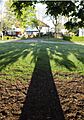
The Meade in Chorltonville
-
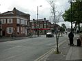
Barlow Moor Road, Chorlton; on the left are two banks NatWest and Santander; Wilbraham Road crosses here
-
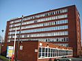
Graeme House, Nicolas Road
-
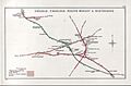
Railway Clearing House diagram of South Manchester railways c. 1914, showing (top) the location of the station north-west of Chorlton junction


