Trafford facts for kids
Quick facts for kids
Borough of Trafford
|
||
|---|---|---|
Trafford Town Hall
|
||
|
||
| Motto(s):
Hold fast that which is good
|
||
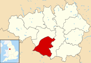
Trafford shown within Greater Manchester
|
||
| Sovereign state | United Kingdom | |
| Country | England | |
| Region | North West | |
| Ceremonial county and city region | Greater Manchester | |
| Incorporated | 1 April 1974 | |
| Administrative HQ | Trafford Town Hall | |
| Government | ||
| • Type | Metropolitan borough | |
| • Body | Trafford Council | |
| Area | ||
| • Total | 40.9 sq mi (106.0 km2) | |
| Area rank | 215th | |
| Population
(2005 est.)
|
||
| • Total | 237,354 | |
| • Rank | 75th | |
| Ethnicity (2021) | ||
| • Ethnic groups |
List
|
|
| Religion (2021) | ||
| • Religion |
List
48.4% Christianity
33.1% no religion 8.7% Islam 2.0% Hinduism 1.0% Judaism 0.8% Sikhism 0.4% Buddhism 0.4% other 5.1% not stated |
|
| Time zone | UTC+0 (GMT) | |
| • Summer (DST) | UTC+1 (BST) | |
| Postcode area |
|
|
| Dialling code | 0161 | |
| ISO 3166 code | GB-TRF | |
| GSS code | E08000009 | |
Trafford is a metropolitan borough in Greater Manchester, England. It has a population of about 237,354 people. The area covers 106.0 square kilometres (40.9 sq mi). It includes places like Old Trafford and the towns of Altrincham, Stretford, Urmston, Partington and Sale.
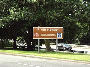
Trafford was created in 1974. It was formed by joining six older districts and part of another. The River Mersey flows through Trafford. It separates North Trafford from South Trafford. This river also marks the old borders of Lancashire and Cheshire. Trafford is the seventh-largest district in Greater Manchester by population.
This area has a very long history. People lived here in the Neolithic (Stone Age) and Bronze Age. The Romans were also here. There are two castles, one of which is a protected ancient site. Over 200 buildings in Trafford are listed as important historical places. In the late 1800s, the number of people living here grew quickly because of the railway.
Trafford is famous for its sports. It is home to Manchester United F.C. and Lancashire County Cricket Club. You can also find Altrincham F.C. and Trafford F.C. here. The Imperial War Museum North, a big museum about wars, opened in 2002 in Trafford.
Trafford has a strong economy. Not many people are unemployed here. It has Trafford Park, a large industrial area. It also has the Trafford Centre, a huge shopping mall. Trafford is one of the few areas in Greater Manchester where people earn more than the national average. The area has both working class and middle class communities, like Bowdon and Hale.
Contents
How Trafford Was Formed
Trafford became a borough on April 1, 1974. This happened because of a law called the Local Government Act 1972. It brought together six old districts and four small areas from another district.
These areas were:
- Altrincham Municipal Borough
- Bowdon Urban District
- Carrington
- Dunham Massey
- Hale Urban District
- Partington
- Sale Municipal Borough
- Stretford Municipal Borough
- Urmston Urban District
- Warburton
Before 1974, Stretford and Urmston were part of Lancashire. All the other areas were in Cheshire. When Trafford was created, it was given "borough status." This meant the head of its council could be called a mayor.
The name "Trafford" was chosen as a compromise. It was a middle ground between names like Altrincham, Stretford, and Sale. Other names suggested were "Crossford" and "Watlingford." But Trafford was chosen because of its "famous sports venue, a major employer as well as historic associations." This refers to Old Trafford (for cricket and football), Trafford Park, and the old de Trafford baronets family.
The name Trafford comes from old English words. Stræt means a street or Roman road, and ford means a river crossing.
Trafford's Long History
Even though the borough of Trafford is new, the area has a very long past.
- Stone Age and Bronze Age: Tools from the Stone Age (Neolithic) have been found in Altrincham and Sale. There is also proof of people living in Timperley during the Bronze Age.
- Roman Times: Pieces of Roman pottery have been found in Urmston. Roman coins were found in Sale. A Roman road that connected two important forts (Chester and York) crosses through Trafford. It goes through Stretford, Sale, and Altrincham.
- Early Settlements: For a long time, the towns in Trafford were mostly farming communities. But Altrincham became a market town in the mid-1200s.
- Industrial Revolution: The Industrial Revolution changed Trafford, but not as much as other parts of Greater Manchester. However, the population doubled between 1841 and 1861. This was because the Manchester, South Junction and Altrincham Railway was built in 1849. It made it easier for people to travel to work in Manchester.
- Industry Today: Trafford developed its own industrial areas like Broadheath (started in 1885) and Trafford Park (started in 1897). While these areas have changed, Trafford Park still employs many thousands of people. Today, Trafford is mostly a place where people live and travel to other areas for work.
Where is Trafford?
Trafford is bordered by the City of Salford to the north. The City of Manchester is to the east. To the south, you'll find the Cheshire East area of Cheshire.
The River Mersey flows from east to west through Trafford. It divides North Trafford from South Trafford. Other rivers here include the Bollin and the River Irwell. The Bridgewater Canal, which opened in 1761, also runs through Trafford. It passes through Stretford, Sale, and Altrincham. The Manchester Ship Canal, opened in 1894, forms part of Trafford's northern and western edges.
Trafford is mostly flat land. Most of it is between 66 feet (20 m) and 98 feet (30 m) above sea level. The highest point is Bowdon Hill, which is about 200 feet (61 m) high. The lowest point is near Warburton, at 36 feet (11 m) above sea level. There are also areas of mossland in low places, like Warburton Moss. Over half of Trafford's land (51.8%) is greenspace. Homes and gardens make up 25.6% of the area.
Here are some of the places you can find in Trafford:
- North Trafford: Cornbrook, Davyhulme, Firswood, Flixton, Gorse Hill, Lostock, Old Trafford, Stretford, Trafford Park and Urmston.
- South Trafford: Altrincham, Ashton-Upon-Mersey, Bowdon, Broadheath, Brooklands, Carrington, Dunham Massey, Hale, Hale Barns, Oldfield Brow, Partington, Sale, Sale Moor, Timperley, Warburton and West Timperley.
How Trafford is Governed
Who Represents Trafford?
People living in Trafford are represented in the British Parliament. They have Members of Parliament (MPs) for three areas:
- Altrincham and Sale West is represented by Connor Rand MP (from the Labour party).
- Stretford and Urmston is represented by Andrew Western MP (Labour).
- Wythenshawe and Sale East covers parts of Trafford and the City of Manchester. It is represented by Mike Kane MP (Labour).
Trafford Council
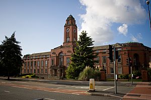
Trafford Council was set up in 1974 to manage the new borough. Its main office is at Trafford Town Hall. The council makes decisions about local policies and how money is spent.
The council's jobs include:
- Setting council tax (local taxes).
- Looking after health services in Trafford.
- Providing social care for people.
- Funding schools.
The council has changed which political party is in charge over the years. Currently, the Labour Party has the most control. As of 2021, Cllr Andrew Western is the leader of the council, and Cllr Laurence Walsh is the current mayor.
In 2007, the Audit Commission said Trafford Council was "improving strongly" in its services. It was given a "three star" rating, meaning it was "performing well." In 2008–09, the council had a budget of about £150.5 million. This money came from council tax (57%) and government grants (43%).
Some smaller areas in Trafford have their own local councils called "civil parishes." These are Carrington, Dunham Massey, Partington, and Warburton. They help with things like planning and promoting tourism.
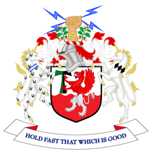
Trafford's Coat of Arms
The coat of arms for Trafford Council has a griffin on a shield. Two unicorns stand on either side of the shield.
- The line across the middle of the shield shows the River Mersey and the canals in Trafford.
- The white lion legs on a red background represent areas once controlled by the De Massey family.
- The red eagle body and head on a white background show areas once controlled by the De Traffords. These symbols come from the old family coats of arms.
- A fist holding lightning bolts stands for Stretford and its electrical industry.
- A cog wheel on an arm represents Altrincham's engineering industry.
- The unicorns stand for Sale and Altrincham.
- Oak branches represent Urmston and the countryside areas of Trafford.
People in Trafford
In the 2001 UK census, Trafford had a population of 210,145 people.
- Most people (75.8%) said they were Christian.
- Smaller groups included Muslims (3.3%), Jewish people (1.1%), Hindus (0.6%), Buddhists (0.2%), and Sikhs (0.5%).
- About 12.0% said they had no religion.
In 2021, the population grew to 235,052.
- About 77.8% of people were White.
- 12.6% were Asian.
- 3.8% were of Mixed ethnic background.
- 3.4% were Black.
Trafford has a lower percentage of people with no academic qualifications (24.7%) compared to the rest of England (28.9%). Also, fewer people in Trafford (8.2%) were born outside the UK than the English average (9.2%).
How Trafford's Population Has Changed
The number of people living in Trafford has changed a lot over time.
| Year | 1801 | 1811 | 1821 | 1831 | 1841 | 1851 | 1861 | 1881 | 1891 | 1911 | 1921 | 1931 | 1951 | 1961 | 1971 | 1981 | 1991 | 2001 | 2011 | ||
|---|---|---|---|---|---|---|---|---|---|---|---|---|---|---|---|---|---|---|---|---|---|
| Population | 10,337 | 11,798 | 13,409 | 14,562 | 16,629 | 19,286 | 23,506 | 64,363 | 77,535 | 116,538 | 125,891 | 153,731 | 201,784 | 224,938 | 225,939 | 222,124 | 214,618 | 210,134 | 226,578 | ||
| Source: A Vision of Britain through Time | |||||||||||||||||||||
The biggest jump in population happened between 1851 and 1871. This was because the Manchester, South Junction and Altrincham Railway was built. The population of Trafford went down a bit between 1971 and 2001. This was similar to what happened in the rest of Greater Manchester. It was due to industries declining and people moving to find new jobs.
Trafford's Economy
In the past, farming was the main activity in Trafford. Even during the Industrial Revolution, the textile industry here did not grow as much as in other parts of Greater Manchester. This was partly because landowners were not keen to invest in factories.
Trafford Park was started in 1897. At its busiest in 1945, it employed 75,000 people. It was the world's first planned industrial estate. Today, it is Europe's largest business park. Over 1,400 companies are located there, employing 40,000 to 50,000 people.
The Trafford Centre opened on September 10, 1998. It is the biggest indoor shopping complex in North West England. More than 30 million people visit it every year. It has 235 stores, 55 restaurants, and a very large cinema.
Trafford is a wealthy area. The average weekly income here is £394. It is the only borough in Greater Manchester (apart from Manchester itself) where the average income is higher than the national average. It's actually the highest in the county. Industries like media, advertising, and public relations are growing here. House prices in Trafford are the highest among all the boroughs in Greater Manchester. They are 45% higher than the county average.
In 2001, Trafford had a low unemployment rate of 2.7%. This was lower than Greater Manchester (3.6%) and England (3.3%). Trafford has the fewest people claiming unemployment benefits in Greater Manchester.
A study by Experian said Trafford was the strongest borough in North West England. It was good at handling sudden changes in the economy. This is because it doesn't rely on businesses that are easily affected by recessions. It also has many large international companies.
Culture and Landmarks
Important Buildings and Places
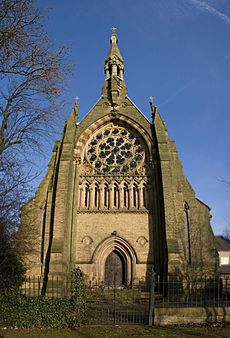
Trafford has many important historical buildings. As of March 2007, there are 6 Grade I listed buildings. These are the most important historical buildings. There are also 11 Grade II* and 228 Grade II listed buildings. Trafford has the second-highest number of Grade I listed buildings in Greater Manchester.
Most of these top-rated buildings are in the south of Trafford:
- The old Church of St. Werburgh in Warburton.
- Dunham Massey Hall, its stables, and carriage house.
- Royd House in Hale.
- The Church of All Saints in Urmston (in the north).
Trafford also has three Sites of Special Scientific Interest. These are special places for nature:
- Brookheys Covert: A woodland with ash, birch, and rowan trees, and a wetland.
- Cotteril Clough: A very diverse woodland.
- Dunham Park: An old park with many oak trees, some from the 1600s.
Over half of Trafford's area is greenspace, including many parks.
Chill Factore is an indoor ski slope in Trafford Park. It has the longest and widest indoor real snow slope in the UK. It is 100 metres (110 yd) wide and 180 metres (200 yd) long.
Dunham Massey Hall and Park is an 18th-century hall with a 250-acre (1.0 km2) deer park. The National Trust now owns them. The hall is in an early Georgian style. It's open to the public and is a popular place to visit.
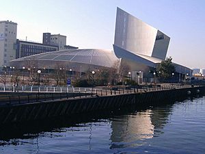
Imperial War Museum North is a war museum in Trafford Park. It opened in 2002. It has won awards for its building and as a top visitor attraction.
Sale Water Park is a 152-acre (62 ha) area of countryside with a 52-acre (21 ha) artificial lake. The lake was made when the M60 motorway was built. It's also home to the Broad Ees Dole wildlife refuge, a special place for birds.
Timperley Old Hall is a medieval site with a moat in Timperley. Digs there have shown people lived in Timperley since the Bronze Age.
Trafford has two medieval castles:
- Dunham Castle: An early medieval castle in Dunham Massey. Its moat is now an ornamental pond.
- Watch Hill Castle: Another early medieval castle near Dunham Massey and Bowdon. It is a protected ancient site.
Sports in Trafford
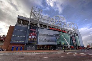
Trafford is famous for its sports teams:
- Football: Manchester United Football Club plays at Old Trafford football ground. They are one of the most successful football clubs in England. They have won the FA Cup 13 times and the Premier League 13 times.
- Cricket: Lancashire County Cricket Club (LCCC) plays at Old Trafford Cricket Ground. This ground hosts international matches. The team has won the county championship eight times.
- Ice Hockey: The Manchester Phoenix ice hockey team used to play at the Altrincham Ice Dome. They were replaced by the Manchester Storm in 2015.
- Rugby Union: The Sale Sharks rugby team used to be based in Trafford. They now play in Salford.
- Local Football: Trafford also has smaller football clubs like Altrincham F.C., Flixton F.C., and Trafford F.C..
- Hockey: There are two hockey clubs, Brooklands and Bowdon, that have teams in the Men's and Women's England Hockey Leagues.
- Pétanque: In 2017, Trafford Pétanque became Trafford's first official Pétanque club.
Education in Trafford
Trafford has 73 primary schools, 17 secondary and grammar schools, and 6 special schools. Trafford uses a selective education system. This means some secondary schools are grammar schools. Students need to pass an 11-plus exam to get into them.
Trafford College is the only further education college in Trafford. It opened in 2008 after two colleges merged.
Trafford's schools perform very well. In 2014, Trafford was ranked 2nd in the UK for overall school performance.
- For Key Stage 2 results (Year 6 pupils), Trafford was 1st in the UK. 87% of pupils reached the expected standard in Reading, Writing, and Arithmetic.
- For GCSE and A-Level results, Trafford was 2nd in the UK. 72.2% of Year 11 pupils achieved 5 GCSEs including English and Maths.
- For A-Levels, 25% of students got 3 A-Levels at grades A*-A. This is twice the national average.
Trafford has 7 grammar schools. All of them are among the top 10 best-performing state schools in Greater Manchester.
Transport in Trafford
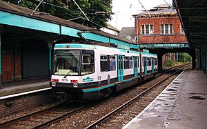
The Manchester Metrolink tram system runs through Trafford from north to south. Its southern end is in Altrincham. Trams go to Piccadilly and Bury. The tram line opened in 1992, replacing an old railway.
There is also a railway line that connects Liverpool and Manchester through Warrington. The Trafford Park Euroterminal, a rail freight terminal, opened in 1993. It can handle 100,000 containers each year.
The council looks after Trafford's roads and pavements. Part of the M60 orbital motorway passes through Trafford.
Many bus services connect towns in Trafford to each other. They also link to Manchester city centre and other areas. Companies like Stagecoach Manchester and Arriva North West run these services. The Trafford Cycle Forum works to encourage cycling in the borough.
Freedom of the Borough
Two special honours have been given:
- Sir Alex Ferguson, the famous football manager, received the Freedom of the Borough of Trafford on October 14, 2013.
- The 207 (Manchester) Field Hospital (part of the Army Reserve) received the Freedom of the Borough on June 21, 2011.
See also
 In Spanish: Municipio metropolitano de Trafford para niños
 | Charles R. Drew |
 | Benjamin Banneker |
 | Jane C. Wright |
 | Roger Arliner Young |


